Archivo: Shropshire UK location map.svg
Saltar a navegación Saltar a búsqueda
Tamaño de esta previsualización PNG del archivo SVG: 550 × 599 píxeles . Otras resoluciones: 220 × 240 píxeles | 441 × 480 píxeles | 551 × 600 píxeles | 705 × 768 píxeles | 940 × 1.024 píxeles | 1.880 × 2.048 píxeles | 1.198 × 1.305 píxeles .
Archivo original (Imagen SVG, nominalmente 1.198 × 1.305 píxeles; tamaño de archivo: 2,13 MB)
| Este es un archivo de Wikimedia Commons . La información de su página de descripción se muestra a continuación. Commons es un repositorio de archivos multimedia con licencia libre. Tu puedes ayudar . |
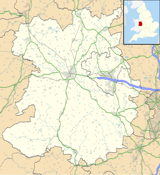
| Descripción | Mapa de Shropshire , Reino Unido con la siguiente información mostrada:
Proyección de mapa equirrectangular en el datum WGS 84, con N / S estirado 165% Límites geográficos:
| |||||
| Fecha | ||||||
| Fuente |
| |||||
| Autor | Nilfanion , creado con datos de Ordnance Survey | |||||
| Permiso ( reutilizando este archivo ) |
| |||||
| Otras versiones | Archivo: Mapa del distrito de Shropshire Reino Unido (en blanco) .svg - Mapa en blanco |
Historial del archivo
Haga clic en una fecha / hora para ver el archivo tal como apareció en ese momento.
| Fecha y hora | Miniatura | Dimensiones | Usuario | Comentario | |
|---|---|---|---|---|---|
| Actual | 19:51, 16 de octubre de 2010 |  | 1.198 × 1.305 (2,13 MB) | Nilfanion | fijar en A442 |
| 19:11, 26 de septiembre de 2010 |  | 1.198 × 1.305 (2,12 MB) | Nilfanion | {{Información | Descripción = Mapa de Shropshire , Reino Unido con la siguiente información mostrada: * Fronteras administrativas * Litoral, lagos y ríos * Carreteras y ferrocarriles * Áreas urbanas Proyección de mapa equirrectangular en el datum WGS 84, con tramo N / S |
Uso de archivos
Más de 100 páginas utilizan este archivo. La siguiente lista muestra las primeras 100 páginas que usan este archivo únicamente. Una lista completa está disponible.
- Albrighton, Bridgnorth
- Todo Stretton
- Alveley
- Ancla, Shropshire
- Aston en Clun
- Atcham
- Attingham Park
- Baschurch
- Campo de batalla, Shropshire
- Bayston Hill
- Bedstone
- Belle Vue, Shrewsbury
- Castillo del obispo
- Bomere Heath
- Boscobel, Shropshire
- Bridgnorth
- Broome, Shropshire
- Broseley
- Buildwas
- Abadía de Buildwas
- Chelmarsh
- Church Stretton
- Cleobury Mortimer
- Clun
- Castillo de Clun
- Clunbury
- Clungunford
- Clunton
- Coalbrookdale
- Coalport
- Condominio
- Cosford, Shropshire
- Coton Hill, Shropshire
- Brazos cobardes
- Jaula
- Dawley
- Ditherington
- Donnington, Telford
- Dorrington, Shropshire
- Edgmond
- Ellesmere, Shropshire
- Reserva Natural Nacional Fenn's, Whixall y Bettisfield Mosses
- Ford, Shropshire
- Frankwell
- Hampton Loade
- Harlescott
- Plano inclinado de heno
- Alto Ercall
- Highley
- Hodnet
- Hopton Heath
- Puente de hierro
- Knockin
- Lilleshall
- Little Stretton, Shropshire
- Llanymynech
- Ludlow
- Castillo de Ludlow
- Madeley, Shropshire
- Market Drayton
- Minsterley
- Much Wenlock
- Myddle
- Nantmawr
- Nesscliffe
- Newcastle, Shropshire
- Newport, Shropshire
- Puertas de roble
- Viejo Oswestry
- Oswestry
- Pontesbury
- Prees
- Priestweston
- Perseguir
- RAF Shawbury
- Ratlinghope
- Roden, Shropshire
- Rodington
- Ruyton-XI-Towns
- Shawbury
- Sheriffhales
- Shifnal
- Castillo de Shrewsbury
- Snailbeach
- San Martín, Shropshire
- Castillo de Stokesay
- Sundorne
- Telford
- Tong, Shropshire
- Uffington, Shropshire
- Upton Magna
- Viroconium Cornoviorum
- Wellington, Shropshire
- Wem
- Westbury, Shropshire
- Weston Lullingfields
- Weston Rhyn
- Whitchurch, Shropshire
- Wistanstow
- Woore
Ver más enlaces a este archivo.
Uso de archivos global
Los siguientes wikis utilizan este archivo:
- Uso en ar.wikipedia.org
- قالب: Mapa de ubicación Reino Unido Shropshire
- Uso en azb.wikipedia.org
- شروزبری
- Uso en bg.wikipedia.org
- Шаблон: ПК Великобритания Шропшър
- Uso en ceb.wikipedia.org
- Plantilya: Mapa de ubicación Reino Unido Shropshire
- Uso en cy.wikipedia.org
- Nodyn: Mapa de ubicación Shropshire
- Uso en es.wikipedia.org
- Shrewsbury
- Catedral de Nuestra Señora Auxiliadora y San Pedro de Alcántara
- Plantilla: Mapa de localización de Shropshire
- Chirk Bank
- Church Stretton
- Cleehill
- Claverley
- Baschurch
- Albrighton
- Alveley
- Cleobury Mortimer
- Acton Burnell
- Clive
- Bomere Heath
- Much Wenlock
- Pantalón (Shropshire)
- Pontesbury
- Ford (Shropshire)
- Ditton Priors
- Dorrington
- Eardington
- Ellesmere (Shropshire)
- Hanwood
- Gobowen
- Highley
- Hinstock
- Broseley
- Aeródromo de Cosford
- Condominio
- Cockshutt
- Brazos cobardes
- Jaula
- Bucknell
- Cheswardine
- Market Drayton
- Minsterley
- Prees
- Prees Higher Heath
- Ruyton-XI-Towns
- RAF Tern Hill
- Shawbury
- Shifnal
- San Martín
- Westbury (Shropshire)
- Tilstock
Ver un uso más global de este archivo.
Contribute a better translation