Archivo: West Lothian UK location map.svg
Saltar a navegación Saltar a búsqueda
Tamaño de esta previsualización PNG del archivo SVG: 526 × 600 píxeles . Otras resoluciones: 210 × 240 píxeles | 421 × 480 píxeles | 674 × 768 píxeles | 898 × 1.024 píxeles | 1.796 × 2.048 píxeles | 1.214 × 1.384 píxeles .
Archivo original (Imagen SVG, nominalmente 1.214 × 1.384 píxeles; tamaño de archivo: 983 KB)
| Este es un archivo de Wikimedia Commons . La información de su página de descripción se muestra a continuación. Commons es un repositorio de archivos multimedia con licencia libre. Tu puedes ayudar . |
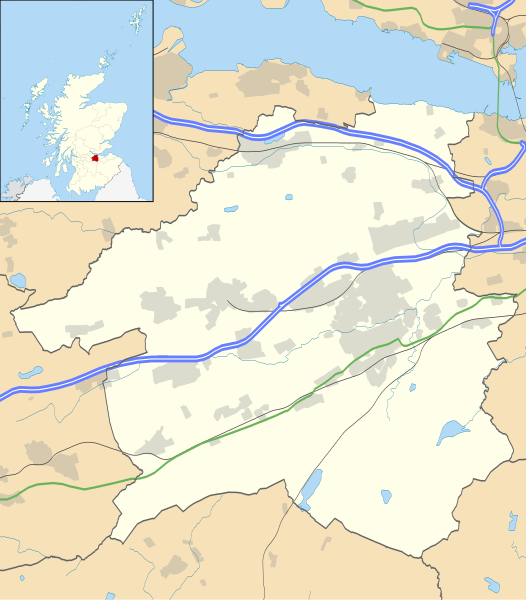
| Descripción | Mapa en blanco de West Lothian , Reino Unido con la siguiente información:
Proyección de mapa equirrectangular en el datum WGS 84, con N / S extendido 175% Límites geográficos:
| |||||
| Fecha | ||||||
| Fuente |
| |||||
| Autor | Nilfanion , creado con datos de Ordnance Survey | |||||
| Permiso ( reutilizando este archivo ) |
| |||||
| Otras versiones | Archivo: West Lothian UK blank map.svg - Blank map |
Historial del archivo
Haga clic en una fecha / hora para ver el archivo tal como apareció en ese momento.
| Fecha y hora | Miniatura | Dimensiones | Usuario | Comentario | |
|---|---|---|---|---|---|
| Actual | 20:26, 26 de septiembre de 2010 |  | 1.214 × 1.384 (983 KB) | Nilfanion | {{Información | Descripción = Mapa en blanco de West Lothian , Reino Unido con la siguiente información mostrada: * Fronteras administrativas * Costa, lagos y ríos * Carreteras y ferrocarriles * Áreas urbanas Proyección de mapa equirrectangular en el datum WGS 84, con N |
Uso de archivos
Las siguientes páginas de la Wikipedia en inglés utilizan este archivo (no se enumeran las páginas de otros proyectos):
- 2021–22 Liga de fútbol del este de Escocia
- Abercorn
- Castillo de Abercorn
- Addiewell
- Estadio Almondvale
- Armadale, West Lothian
- Ballencrieff, West Lothian
- Hospital General de Bangour
- Hospital Bangour Village
- Bathgate
- Castillo de Bathgate
- Bathville
- Bellsquarry
- Blackburn, West Lothian
- Blackridge, West Lothian
- Boghall
- Breich
- Bridgend, West Lothian
- Broxburn
- Burnwynd
- Castillo de Cairns
- Castillo Greg
- Cobbinshaw
- Craigshill
- Decanos, West Lothian
- Dechmont
- Castillo de Duntarvie
- East Calder
- East Whitburn
- Ecclesmachan
- Eliburn
- Fauldhouse
- Greenrigg
- Harthill, Escocia
- Casa Hopetoun
- Kingscavil
- Kirknewton, West Lothian
- Linburn Center
- Linlithgow
- Sociedad del Canal de la Unión de Linlithgow
- Lista de castillos en West Lothian
- Lista de casas monásticas en Escocia
- Livingston, West Lothian
- Livingston Village
- Longridge, West Lothian
- Mid Calder
- Castillo de Murieston
- Newton, West Lothian
- Philpstoun
- Polbeth
- Pumpherston
- Campamento Ritchie
- Fútbol juvenil escocés Región Este Premier League Sur
- Seafield, West Lothian
- Hospital de San Juan, Livingston
- Hospital de San Miguel, Linlithgow
- Stoneyburn
- Castillo de Strathbrock
- Hospital Tippethill House
- Torphichen
- Uphall
- Estación Uphall
- West Calder
- Westfield, West Lothian
- Whitburn, West Lothian
- Wilkieston
- Winchburgh
- Usuario: LordHarris / sandbox2
- Módulo: Mapa de ubicación / datos / Escocia West Lothian
- Módulo: Mapa de ubicación / datos / Scotland West Lothian / doc
Uso de archivos global
Los siguientes wikis utilizan este archivo:
- Uso en ar.wikipedia.org
- قالب: Mapa de ubicación Scotland West Lothian
- Uso en bg.wikipedia.org
- Шаблон: ПК Великобритания Западен Лоудиън
- Uso en ceb.wikipedia.org
- Plantilya: Mapa de ubicación Scotland West Lothian
- Uso en de.wikipedia.org
- Vorlage: Positionskarte Schottland West Lothian
- Uso en es.wikipedia.org
- Livingston
- Wikiproyecto: Ilustración / Taller de Cartografía / Realizaciones / Europa
- Plantilla: Mapa de localización de West Lothian
- East Whitburn
- Longridge (West Lothian)
- East Calder
- Dechmont
- Blackburn (West Lothian)
- Linlithgow
- Broxburn
- Bridgend (West Lothian)
- Blackridge
- Armadale
- Addiewell
- Kirknewton
- Torphichen
- Fauldhouse
- Stoneyburn
- Seafield
- Winchburgh
- Polbeth
- Mid Calder
- Whitburn
- West Calder
- Uso en fa.wikipedia.org
- الگو: Mapa de ubicación Scotland West Lothian
- لیوینگستون ، اسکاتلند
- آرمادیل ، وست لوتیان
- بلکبرن ، وست لوتیان
- ویتبرن ، لوتیان غربی
- تورفیچن
- وست کالدر
- استونیبرن
- میدکالدر
- وستفیلد ، لوتیان غربی
- فالدهاوس
- بلکریج (لوتیان غربی)
- Uso en fr.wikipedia.org
- Bathgate
- Livingston (Écosse)
- Estadio Almondvale
- Blackburn (Écosse)
- Linlithgow
- Abercorn (Écosse)
- Modelo: Géolocalisation / West Lothian
- Uphall
- Armadale (West Lothian)
- Broxburn
Ver un uso más global de este archivo.
Metadatos
Contribute a better translation