Saltar a navegación Saltar a búsqueda
Tamaño de esta previsualización PNG del archivo SVG: 406 × 599 píxeles . Otras resoluciones: 162 × 240 píxeles | 325 × 480 píxeles | 406 × 600 píxeles | 520 × 768 píxeles | 693 × 1.024 píxeles | 1.387 × 2.048 píxeles | 884 × 1.305 píxeles .
Archivo original (Imagen SVG, nominalmente 884 × 1.305 píxeles; tamaño de archivo: 2,38 MB)
| Este es un archivo de Wikimedia Commons . La información de su página de descripción se muestra a continuación. Commons es un repositorio de archivos multimedia con licencia libre. Tu puedes ayudar . |
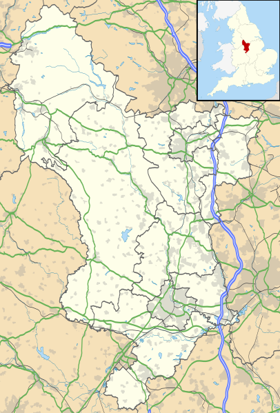
| Descripción | Mapa de Derbyshire , Reino Unido con la siguiente información mostrada:
Proyección de mapa equirrectangular en el datum WGS 84, con N / S estirado 165% Límites geográficos:
| |||||
| Fecha | ||||||
| Fuente |
| |||||
| Autor | Nilfanion , creado con datos de Ordnance Survey | |||||
| Permiso ( reutilizando este archivo ) |
| |||||
| Otras versiones | Archivo: Devon Reino Unido mapa del distrito (en blanco) .svg - Mapa en blanco |
Historial del archivo
Haga clic en una fecha / hora para ver el archivo tal como apareció en ese momento.
| Fecha y hora | Miniatura | Dimensiones | Usuario | Comentario | |
|---|---|---|---|---|---|
| Actual | 18:46, 26 de septiembre de 2010 |  | 884 × 1.305 (2,38 MB) | Nilfanion | {{Información | Descripción = Mapa de Derbyshire , Reino Unido con la siguiente información mostrada: * Fronteras administrativas * Litoral, lagos y ríos * Carreteras y ferrocarriles * Áreas urbanas Proyección de mapa equirrectangular en el datum WGS 84, con tramo N / S |
Uso de archivos
Más de 100 páginas utilizan este archivo. La siguiente lista muestra las primeras 100 páginas que usan este archivo únicamente. Una lista completa está disponible.
- Alfreton
- Allenton, Derby
- Allestree
- Alvaston
- Ashbourne, Derbyshire
- Aston-on-Trent
- Cobertizo de locomotoras de Barrow Hill
- Baslow
- Birchinlee
- Bolsover
- Castillo de Bolsover
- Brassington
- Bretby Hall
- Cuenca de Bugsworth
- Buxton
- Buxworth
- Abadía de Calke
- Castleton, Derbyshire
- Chaddesden
- Capilla Milton
- Casa de Chatsworth
- Chellaston
- Chesterfield, Derbyshire
- Chinley
- Crich
- Cromford
- Darley Dale
- Museo y galería de arte Derby
- Derbyshire
- Doveridge
- Dronfield
- Duffield, Derbyshire
- Eckington, Derbyshire
- Edale
- Eyam
- Findern
- Gamesley
- Glossop
- Gran Hucklow
- Greenhill Lane
- Grindleford
- Haddon Hall
- Hadfield, Derbyshire
- Hardwick Hall
- Hartington, Derbyshire
- Hartshorne, Derbyshire
- Hasland
- Hathersage
- Heage
- Heanor
- Heatherton Village
- Esperanza, Derbyshire
- Ilkeston
- Killamarsh
- Leam, Derbyshire
- Un poco más
- Long Eaton
- Mackworth, Derby
- Markeaton
- Matlock, Derbyshire
- Baño Matlock
- Melbourne, Derbyshire
- Mickleover
- Monyash
- Molinos nuevos
- Newhaven, Derbyshire
- Normanton, Derby
- Oakwood, Derby
- Osmaston, Derby
- Peak Forest
- Tranvía Peak Forest
- Pentrich
- Pilsbury
- Pleasley
- Salón Renishaw
- Repton
- Ripley, Derbyshire
- Rowsley
- Sandiacre
- Bloqueo Shelton
- Shirebrook
- South Wingfield
- Gorrión
- Spondon
- Staveley, Derbyshire
- Swadlincote
- Tansley
- Thornhill, Derbyshire
- Tideswell
- Tintwistle
- Tissington
- Caverna del acantilado de Treak
- Tunstead Milton
- West Hallam
- Puente Whaley
- Lo que está bien
- Whitwell, Derbyshire
- Willington, Derbyshire
- Winster
- Wirksworth
Ver más enlaces a este archivo.
Uso de archivos global
Los siguientes wikis utilizan este archivo:
- Uso en ar.wikipedia.org
- قالب: Mapa de ubicación Reino Unido Derbyshire
- Uso en bg.wikipedia.org
- Шаблон: ПК Великобритания Дарбишър
- Uso en ca.wikipedia.org
- Plantilla: Mapa de ubicación Regne Unit Derbyshire
- Uso en ceb.wikipedia.org
- Plantilya: Mapa de ubicación Reino Unido Derbyshire
- Uso en cs.wikipedia.org
- Šablona: LocMap Derbyshire
- Uso en cy.wikipedia.org
- Nodyn: Mapa de ubicación Reino Unido Derbyshire
- Uso en el.wikipedia.org
- Πρότυπο: Mapa de ubicación Ηνωμένο Βασίλειο Ντέρμπισαϊρ
- Uso en es.wikipedia.org
- derby
- Creswell Crags
- Sofá
- Plantilla: Mapa de localización de Derbyshire
- Wardlow
- Casa de Chatsworth
- Matlock
- Lo que está bien
- Buxton
- Alfreton
- Ambergate
- Chinley
- Cruz de arcilla
- Ashbourne (Derbyshire)
- Ashover
- Payaso
- Coton en los olmos
- Creswell (Derbyshire)
- Aston-on-Trent
- Bakewell
- Bamford
- Barlborough
- Crich
- Cromford
- Hathersage
- Gran Longstone
- Grassmoor
- Glossop
- Glapwell
- Grindleford
- Hatton (Derbyshire)
- Henar
- Heage
- Cutthorpe
- Darley Dale
- Botellas Denby
- Doe Lea
- Barrow Hill
- Baslow
- Belper
- Bonsall
- Agujeros de paloma
- Duckmanton
Ver un uso más global de este archivo.