| Trenton, Nueva Jersey | |
|---|---|
| Ciudad de Trenton | |
 Centro en el río Delaware | |
 Bandera | |
| Apodo (s): Ciudad capital Punto de inflexión de la revolución. | |
| Lema (s): "Trenton hace, el mundo se lleva" [1] | |
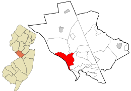 Ubicación dentro del condado de Mercer  Mapa interactivo de Trenton, Nueva Jersey | |
 Mapa de la Oficina del Censo de Trenton, Nueva Jersey | |
 Trenton Ubicación en el condado de Mercer  Trenton Ubicación en Nueva Jersey  Trenton Ubicación en los Estados Unidos | |
| Coordenadas: 40.223841 ° N 74.763624 ° W40 ° 13′26 ″ N 74 ° 45′49 ″ W / Coordenadas : 40.223841 ° N 74.763624 ° W40°13′26″N 74°45′49″W / [2] [3] | |
| País | |
| Estado | |
| condado | |
| Fundado | 3 de junio de 1719 |
| Incorporado | 13 de noviembre de 1792 |
| Nombrado para | William Trent |
| Gobierno[8] | |
| • Escribe | Ley Faulkner |
| • Cuerpo | Ayuntamiento |
| • Alcalde | Reed Gusciora (el mandato finaliza el 30 de junio de 2022) [4] [5] |
| • Administrador | Adam E. Cruz [6] |
| • Secretario municipal | Dwayne M. Harris [7] |
| Zona[2] | |
| • Total | 21,25 km 2 (8,21 millas cuadradas ) |
| • Tierra | 19,63 km 2 (7,58 millas cuadradas ) |
| • Agua | 0,63 millas cuadradas (1,62 km 2 ) 7,62% |
| Rango de área | 229 de 565 en el estado 9 de 12 en el condado [2] |
| Elevación[9] | 49 pies (15 m) |
| Población ( 2010 ) [10] [11] [12] | |
| • Total | 84,913 |
| • Estimación (2019) [13] | 83,203 |
| • Rango | 413º en el país (a partir de 2019) [14] 10º de 565 en el estado 2º de 12 en el condado [15] |
| • Densidad | 11,101.9 / mi sq (4,286.5 / km 2 ) |
| • Rango de densidad | 26 de 565 en el estado 1 de 12 en el condado [15] |
| Zona horaria | UTC − 05: 00 ( Este (EST) ) |
| • Verano ( DST ) | UTC − 04: 00 ( Este (EDT) ) |
| Códigos ZIP | |
| Codigo de AREA | 609 [18] |
| Código FIPS | 3402174000 [2] [19] [20] |
| ID de función GNIS | 0885421 [2] [21] |
| Sitio web | trentonnj |
Trenton es la ciudad capital del estado estadounidense de Nueva Jersey y la sede del condado de Mercer . [22] Sirvió brevemente como la capital de los Estados Unidos en 1784. [23] El área metropolitana de la ciudad, que consiste en el condado de Mercer, se agrupa con el área estadística combinada de Nueva York por la Oficina del censo de los Estados Unidos , [24] pero limita directamente con el área metropolitana de Filadelfia y fue desde 1990 hasta 2000 parte del Área Estadística Combinada de Filadelfia . [25] A partir delCenso de Estados Unidos de 2010 , Trenton tenía una población de 84.913, [10] [11] [12] lo que lo convierte en el décimo municipio más grande del estado después de haber sido el noveno municipio más grande del estado en 2000. [26] La población disminuyó en 490 ( -0,6%) de los 85.403 contabilizados en el censo de 2000 , que a su vez había disminuido en 3.272 (-3,7%) de los 88.675 contabilizados en el censo de 1990 . [27] La oficina de censo 's Population Estimates Programa calcula que la población de la ciudad era de 83.203 en 2019, [13] el ranking de la ciudad, el 413o más poblado en el país .[14]
Trenton se remonta al menos al 3 de junio de 1719, cuando se mencionó la designación de un agente de policía para Trenton mientras el área todavía formaba parte del condado de Hunterdon . Los límites del municipio de Trenton se registraron a partir del 2 de marzo de 1720. [28] Se construyeron un palacio de justicia y una cárcel en Trenton alrededor de 1720, y los propietarios del condado de Hunterdon se reunían anualmente en Trenton. [29] Trenton se convirtió en la capital de Nueva Jersey el 25 de noviembre de 1790, y la ciudad de Trenton se formó dentro del municipio de Trenton el 13 de noviembre de 1792. El municipio de Trenton se incorporó como uno de los 104 municipios del grupo inicial de Nueva Jersey por un acto de la Legislatura de Nueva Jerseyel 21 de febrero de 1798. El 22 de febrero de 1834, partes del municipio de Trenton se tomaron para formar el municipio de Ewing . La parte restante del municipio de Trenton fue absorbida por la ciudad de Trenton el 10 de abril de 1837. Se llevaron a cabo una serie de anexiones durante un período de 50 años, y la ciudad absorbió el distrito de South Trenton (14 de abril de 1851), partes del municipio de Nottingham. (14 de abril de 1856), tanto el municipio de Chambersburg Township como el municipio de Millham (ambos el 30 de marzo de 1888), así como Wilbur Borough (28 de febrero de 1898). Partes del municipio de Ewing y del municipio de Hamilton se anexaron a Trenton el 23 de marzo de 1900. [28] [30]
Historia

Los primeros habitantes conocidos del área que es hoy Trenton fueron los nativos americanos Lenape . [31] El primer asentamiento europeo en lo que se convertiría en Trenton fue establecido por cuáqueros en 1679, en la región entonces llamada Cataratas del Delaware, dirigido por Mahlon Stacy de Handsworth , Sheffield , Inglaterra. Los cuáqueros estaban siendo perseguidos en Inglaterra en ese momento y América del Norte brindó la oportunidad de ejercer su libertad religiosa. [32]
En 1719, la ciudad adoptó el nombre de "Trent-towne", en honor a William Trent , uno de sus principales terratenientes que compró gran parte de las tierras circundantes a la familia de Stacy. Este nombre más tarde se acortó a "Trenton". [33] [34] [35]
Durante la Guerra de Independencia de los Estados Unidos , la ciudad fue el escenario de la Batalla de Trenton , la primera victoria militar de George Washington . Entre el 25 y el 26 de diciembre de 1776, Washington y su ejército, después de cruzar el gélido río Delaware hasta Trenton, derrotaron a las tropas de Hesse guarnecidas allí. [36] La segunda batalla de Trenton, la batalla de Assunpink Creek , se libró aquí el 2 de enero de 1777. [37] Después de la guerra, el Congreso de la Confederación se reunió durante dos meses en la French Arms Tavern desde el 1 de noviembre de 1784. , al 24 de diciembre de 1784. [23] Si bien la ciudad fue preferida porNueva Inglaterra y otros estados del norte como capital permanente del nuevo país, los estados del sur finalmente prevalecieron en su elección de una ubicación al sur de la línea Mason-Dixon . [38] El 21 de abril de 1789, la ciudad organizó una recepción para George Washington en su viaje a la ciudad de Nueva York para su primera inauguración . [39]
Trenton se convirtió en la capital del estado en 1790, pero antes de ese año la legislatura de Nueva Jersey se reunía a menudo en la ciudad. [40] La ciudad fue incorporada en 1792. [28]
Durante la Guerra de 1812 , el hospital principal del Ejército de los Estados Unidos estaba en un sitio en Broad Street. [41]
A lo largo del siglo XIX, Trenton creció de manera constante, ya que los inmigrantes europeos llegaron a trabajar en sus fábricas de cerámica y cables. En 1837, con la población ahora demasiado grande para el gobierno por consejo, se adoptó un nuevo gobierno de alcalde, con estatutos que siguen vigentes hasta el día de hoy. [42]
Los Trenton Six eran un grupo de hombres negros arrestados por el presunto asesinato de un comerciante blanco anciano en enero de 1948 con una botella de refresco. Fueron arrestados sin orden judicial, sin abogados y condenados a muerte sobre la base de lo que se describió como confesiones obtenidas bajo coacción. Con la participación del Partido Comunista y la NAACP, hubo varias apelaciones, lo que resultó en un total de cuatro juicios. Finalmente, los acusados (a excepción de uno que murió en prisión) fueron puestos en libertad. El incidente fue el tema del libro Jersey Justice: The Story of the Trenton Six , escrito por Cathy Knepper. [43] [44]
Disturbios de 1968
Los disturbios de Trenton de 1968 fueron un importante disturbio civil que tuvo lugar durante la semana posterior al asesinato del líder de los derechos civiles Martin Luther King Jr. en Memphis el 4 de abril. Disturbios racialesestalló en todo el país tras el asesinato del activista de derechos civiles. Más de 200 negocios de Trenton, la mayoría en el centro de la ciudad, fueron saqueados e incendiados. Más de 300 personas, la mayoría de ellos jóvenes negros, fueron arrestadas por cargos que iban desde asalto e incendio premeditado hasta saqueo y violación del toque de queda de emergencia del alcalde. Además de 16 policías heridos, 15 bomberos fueron tratados en hospitales de la ciudad por inhalación de humo, quemaduras, esguinces y cortes sufridos mientras luchaban contra incendios furiosos o por lesiones infligidas por alborotadores. Los ciudadanos del núcleo urbano de Trenton a menudo activaban falsas alarmas y luego arrojaban ladrillos a los bomberos que respondían a las cajas de alarma. Esta experiencia, junto con experiencias similares en otras ciudades importantes, terminó efectivamente con el uso de camiones de bomberos de cabina abierta. Como medida provisional,El Departamento de Bomberos de Trenton fabricó recintos de cabina temporales con placas de acero para plataformas hasta que se pudiera obtener equipo nuevo. La ciudad estimó inicialmente las pérdidas sufridas por las empresas del centro de la ciudad en $ 7 millones, pero el total de reclamaciones y acuerdos de seguros llegó a $ 2,5 millones.[45]
El barrio de Battle Monument de Trenton fue el más afectado. Desde la década de 1950, North Trenton había sido testigo de un éxodo constante de residentes de clase media, y los disturbios marcaron el final de North Trenton. En la década de 1970, la región se había convertido en una de las más arruinadas y plagadas de delitos de la ciudad. [46]
Geografía
Según la Oficina del Censo de los Estados Unidos , la ciudad tenía un área total de 21,25 km 2 (8,21 millas cuadradas ), incluidas 19,63 km 2 (7,58 millas cuadradas ) de tierra y 1,62 km 2 (0,63 millas cuadradas ) de agua (7,62%). . [2] [3]
Varios puentes a través del río Delaware conectan Trenton con Morrisville , Pensilvania , todos los cuales son operados por la Comisión Conjunta de Puentes de Peaje del Río Delaware . [47] El puente de peaje Trenton-Morrisville , construido originalmente en 1952, se extiende por 404 m (1.324 pies) y lleva la Ruta 1 de los Estados Unidos . [48] El Puente Inferior de Trenton , con la leyenda "Trenton Makes The World Takes Bridge", es un tramo de 1.022 pies (312 m) que se construyó en 1928 en el sitio de un puente que data de 1804. [49] El puente de Calhoun Street , que data de 1884, tiene 388 m (1274 pies) de largo. [50]
Trenton se encuentra cerca del centro geográfico del estado, que se encuentra a 8 km (5 millas) al sureste de la ciudad. [51] [52] La ciudad a veces se incluye como parte del norte de Jersey y como la ciudad más al sur de la región de los tres estados , mientras que otros la consideran parte del sur de Jersey y, por lo tanto, la ciudad más al norte del valle de Delaware . [53]
Sin embargo, el condado de Mercer constituye su propia área estadística metropolitana , formalmente conocida como Trenton-Princeton MSA. [54] Los lugareños consideran que Trenton es parte de un área ambigua conocida como Central Jersey y, por lo tanto, no forma parte de ninguna de las dos regiones. Por lo general, están divididos en cuanto a si se encuentran dentro de la esfera de influencia de Nueva York o Filadelfia. Si bien está geográficamente más cerca de Filadelfia, muchas personas que se han mudado recientemente al área viajan diariamente a la ciudad de Nueva York y se han mudado allí para escapar de los altos costos de vivienda de la región de Nueva York.
Trenton es una de las dos capitales estatales que limitan con otro estado; la otra es Carson City, Nevada . [55] También es una de las siete capitales estatales ubicadas dentro de la meseta de Piamonte .
Trenton limita con el municipio de Ewing , el municipio de Hamilton y el municipio de Lawrence en el condado de Mercer; y Falls Township , Lower Makefield Township y Morrisville en el condado de Bucks, Pensilvania , al otro lado del río Delaware en Pensilvania . [56] [57] [58]
El corredor noreste pasa por Trenton. Una línea recta trazada entre el centro de la ciudad, Filadelfia y el centro de Manhattan pasaría a 2000 pies de la Casa del Estado de Nueva Jersey .
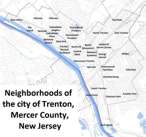
Barrios
La ciudad de Trenton alberga numerosos barrios y subbarrios. Los barrios principales se toman de las cuatro direcciones cardinales (norte, sur, este y oeste). Trenton fue una vez el hogar de grandes comunidades italianas, húngaras y judías, pero, desde la década de 1950, los cambios demográficos han convertido a la ciudad en un enclave urbano relativamente segregado de afroamericanos de ingresos medios y bajos. Los italianos se encuentran dispersos por toda la ciudad, pero una comunidad italiana distinta se centra en el barrio de Chambersburg , en el sur de Trenton. [59]Esta comunidad ha estado en declive desde la década de 1970, en gran parte debido a los cambios económicos y sociales en los suburbios que rodean la ciudad. Hoy Chambersburg tiene una gran comunidad latina. Muchos de los inmigrantes latinos son de México, Guatemala y Nicaragua. También hay una comunidad asiática importante y en crecimiento en el vecindario de Chambersburg compuesta principalmente por refugiados birmanos y butaneses / nepaleses.
El Barrio Norte , que alguna vez fue la meca de la clase media de la ciudad, es ahora uno de los más afectados económicamente, destrozado por los disturbios raciales que siguieron al asesinato de Martin Luther King Jr. en 1968. No obstante, el área aún conserva muchos elementos arquitectónicos e históricos importantes. sitios. North Trenton todavía tiene un gran vecindario polaco-estadounidense que limita con Lawrence Township, muchos de los cuales asisten a la iglesia católica romana de St. Hedwig en Brunswick Avenue. La iglesia de Santa Eduvigis fue construida en 1904 por inmigrantes polacos, muchas de cuyas familias aún asisten a la iglesia. North Trenton también alberga la histórica Iglesia Bautista de Shiloh, una de las casas de culto más grandes de Trenton y la iglesia afroamericana más antigua de la ciudad, fundada en 1888.[60] La iglesia es pastoreada actualmente por el Rev. Darrell L. Armstrong, quien llevó la antorcha olímpica en 2002 para los Juegos Olímpicos de Invierno en Salt Lake City. También ubicado en el extremo sur de North Trenton se encuentra el Monumento a la Batalla de la ciudad, también conocido como "Cinco Puntos". Es una estructura de 150 pies (46 m) que marca el lugar donde George Washington 's Ejército Continental lanzó la batalla de Trenton durante la guerra revolucionaria americana . Se enfrenta al centro de Trenton y es un símbolo del pasado histórico de la ciudad. [61]
South Ward es un vecindario diverso, hogar de muchos residentes latinoamericanos, italoamericanos y afroamericanos. [62]
East Ward es el vecindario más pequeño de Trenton y alberga el Trenton Transit Center y la Trenton Central High School . El barrio de Chambersburg se encuentra dentro del East Ward y una vez fue conocido en la región como un destino por sus numerosos restaurantes y pizzerías italianos . Con la demografía cambiante, muchas de estas empresas han cerrado o se han trasladado a ubicaciones suburbanas.
West Ward es el hogar de los vecindarios más suburbanos de Trenton.
Los barrios de la ciudad incluyen: [63]
- Centro de Trenton
- Hannover / Academia
- Mill Hill
- East Trenton
- Coalport / North Clinton
- Ewing / Carroll
- Greenwood / Hamilton
- Villa Park
- Wilbur
- Western Trenton (no es lo mismo que West Trenton , que está fuera de los límites de la ciudad en Ewing )
- Berkeley Square
- Cadwalader Heights
- Centro Oeste
- Fisher / Richey / Perdicaris
- Glen Afton
- Hillcrest
- Hiltonia
- Parkside
- Pennington / Prospecto
- Stuyvesant / Prospecto
- La isla
- West End
- South Trenton
- Chambersburg
- Parque de la castaña
- Isla de los patos
- Franklin Park
- Lamberton / frente al mar
- North Trenton
- Monumento de batalla (cinco puntos)
- Norte 25
- Carretera superior
Clima
Según la clasificación climática de Köppen , Trenton se encuentra en la transición de un clima subtropical húmedo ( Cfa ) a un clima continental húmedo más frío ( Dfa ), favoreciendo al primero, con cuatro estaciones de aproximadamente la misma duración y precipitaciones distribuidas de manera bastante uniforme a lo largo del año. El clima de Cfa es el resultado del calentamiento adiabático de los Apalaches , la baja altitud y la proximidad a la costa sin estar en el borde inmediato de temperaturas moderadas. [64]
Los inviernos son fríos y húmedos: la temperatura promedio diaria en enero es 32.0 ° F (0.0 ° C), [65] y temperaturas de 10 ° F (-12 ° C) o menos ocurren en 3.9 noches al año, mientras que hay 16– 17 días en los que la temperatura no supera el punto de congelación. Pueden ocurrir episodios de frío extremo y viento con valores de sensación térmica por debajo de 0 ° F (−18 ° C). La zona de rusticidad de las plantas en el Tribunal Municipal de Trenton es 7a con una temperatura del aire mínima extrema anual promedio de 1.2 ° F (−17.1 ° C). [66]
Los veranos son calurosos y húmedos, con un promedio diario de julio de 76.0 ° F (24.4 ° C); las temperaturas que alcanzan o superan los 32 ° C (90 ° F) ocurren entre 15 y 16 días. Pueden ocurrir episodios de calor y humedad extremos con valores de índice de calor que alcanzan los 100 ° F (38 ° C). Los extremos en la temperatura del aire han oscilado entre -14 ° F (-26 ° C) el 9 de febrero de 1934, hasta 106 ° F (41 ° C) tan recientemente como el 22 de julio de 2011. [67] Sin embargo, la temperatura del aire alcanzó los 0ºC. ° F (−18 ° C) o 100 ° F (38 ° C) son poco comunes.
La precipitación promedio es de 48,34 pulgadas (123 cm) por año, que se distribuye de manera bastante uniforme a lo largo del año. El mes más seco en promedio es febrero, con 2,81 pulgadas (71 mm) de precipitación en promedio, mientras que el mes más húmedo es julio con 5,32 pulgadas (14 cm) de lluvia en promedio, lo que se corresponde con el pico anual de actividad de tormentas eléctricas . El récord histórico de lluvia en un solo día es de 7,25 pulgadas (18,4 cm) el 16 de septiembre de 1999, durante el paso del huracán Floyd . El récord de lluvia mensual de todos los tiempos es de 14,55 pulgadas (37,0 cm) en agosto de 1955, debido al paso del huracán Connie y el huracán Diane.. El año más húmedo registrado fue 1996, cuando cayeron 172 cm (67,90 pulgadas) de precipitación. Por otro lado, el mes más seco registrado fue octubre de 1963, cuando solo se registraron 0,05 pulgadas (0,1 cm) de lluvia. Las 28,79 pulgadas (73 cm) de precipitación registradas en 1957 fueron las más bajas jamás registradas en la ciudad. [68]
Las nevadas pueden variar aún más de un año a otro. El promedio de nieve estacional (noviembre-abril) total es de 24 a 30 pulgadas (61 a 76 cm), pero ha variado desde tan solo 2 pulgadas (5,1 cm) en el invierno de 1918-19 hasta tan alto como 76,5 pulgadas (194,3 cm) en 1995-1996, que incluyó la mayor nevada de una sola tormenta, la ventisca del 7 al 8 de enero de 1996 , cuando cayeron 24,2 pulgadas (61,5 cm) de nieve. [69] El mes más nevado promedio es febrero, que se corresponde con el pico anual en la actividad del nordeste .
| Datos climáticos de Trenton, Nueva Jersey (normales de 1981 a 2010) | |||||||||||||
|---|---|---|---|---|---|---|---|---|---|---|---|---|---|
| Month | Jan | Feb | Mar | Apr | May | Jun | Jul | Aug | Sep | Oct | Nov | Dec | Year |
| Record high °F (°C) | 73 (23) | 76 (24) | 87 (31) | 93 (34) | 99 (37) | 100 (38) | 106 (41) | 105 (41) | 101 (38) | 94 (34) | 83 (28) | 76 (24) | 106 (41) |
| Mean maximum °F (°C) | 59 (15) | 60 (16) | 70 (21) | 81 (27) | 88 (31) | 93 (34) | 96 (36) | 93 (34) | 89 (32) | 80 (27) | 70 (21) | 62 (17) | 96 (36) |
| Average high °F (°C) | 39.0 (3.9) | 42.2 (5.7) | 50.9 (10.5) | 61.4 (16.3) | 71.8 (22.1) | 80.8 (27.1) | 85.3 (29.6) | 83.6 (28.7) | 76.1 (24.5) | 65.0 (18.3) | 54.5 (12.5) | 43.1 (6.2) | 62.9 (17.2) |
| Daily mean °F (°C) | 31.1 (−0.5) | 34.0 (1.1) | 41.4 (5.2) | 51.2 (10.7) | 61.1 (16.2) | 70.5 (21.4) | 75.7 (24.3) | 73.9 (23.3) | 66.2 (19.0) | 54.6 (12.6) | 45.7 (7.6) | 35.3 (1.8) | 53.4 (11.9) |
| Average low °F (°C) | 23.2 (−4.9) | 25.8 (−3.4) | 31.9 (−0.1) | 41.0 (5.0) | 50.5 (10.3) | 60.3 (15.7) | 66.0 (18.9) | 64.2 (17.9) | 56.4 (13.6) | 44.2 (6.8) | 36.9 (2.7) | 27.6 (−2.4) | 44.1 (6.7) |
| Mean minimum °F (°C) | 8 (−13) | 8 (−13) | 18 (−8) | 30 (−1) | 40 (4) | 51 (11) | 58 (14) | 55 (13) | 45 (7) | 34 (1) | 24 (−4) | 13 (−11) | 4 (−16) |
| Record low °F (°C) | −13 (−25) | −14 (−26) | 1 (−17) | 11 (−12) | 33 (1) | 41 (5) | 48 (9) | 41 (5) | 31 (−1) | 22 (−6) | 12 (−11) | −7 (−22) | −14 (−26) |
| Average precipitation inches (mm) | 3.16 (80) | 2.31 (59) | 4.14 (105) | 3.54 (90) | 4.37 (111) | 4.41 (112) | 4.95 (126) | 4.10 (104) | 4.27 (108) | 4.18 (106) | 3.31 (84) | 3.70 (94) | 46.44 (1,179) |
| Average snowfall inches (cm) | 6.0 (15) | — | 5.2 (13) | 0 (0) | 0 (0) | 0 (0) | 0 (0) | 0 (0) | 0 (0) | 0 (0) | 0.6 (1.5) | 3.5 (8.9) | 15.8 (40) |
| Average relative humidity (%) | 65.4 | 61.7 | 58.0 | 57.0 | 62.1 | 66.1 | 66.2 | 68.8 | 69.8 | 68.8 | 66.9 | 66.5 | 64.8 |
| Average dew point °F (°C) | 21.7 (−5.7) | 22.8 (−5.1) | 28.1 (−2.2) | 37.7 (3.2) | 48.7 (9.3) | 59.4 (15.2) | 63.9 (17.7) | 63.5 (17.5) | 57.0 (13.9) | 45.6 (7.6) | 35.9 (2.2) | 26.5 (−3.1) | 42.7 (5.9) |
| Mean monthly sunshine hours | 163.1 | 169.7 | 207.4 | 227.2 | 248.1 | 262.8 | 269.2 | 252.5 | 215.0 | 201.5 | 149.3 | 140.1 | 2,505.9 |
| Percent possible sunshine | 54 | 57 | 56 | 57 | 56 | 58 | 59 | 59 | 57 | 58 | 50 | 48 | 56 |
| Source 1: NOAA (sun 1961–1981)[65][70][71] | |||||||||||||
| Source 2: PRISM Climate Group (humidity and dew point)[72] | |||||||||||||
Demografía
| Población histórica | |||
|---|---|---|---|
| Censo | Música pop. | % ± | |
| 1790 | 1.946 | - | |
| 1810 | 3000 | - | |
| 1820 | 3.942 | 31,4% | |
| 1830 | 3.925 | −0,4% | |
| 1840 | 4.035 | * | 2,8% |
| 1850 | 6.461 | 60,1% | |
| 1860 | 17.228 | * | 166,6% |
| 1870 | 22,874 | 32,8% | |
| 1880 | 29,910 | 30,8% | |
| 1890 | 57.458 | * | 92,1% |
| 1900 | 73.307 | 27,6% | |
| 1910 | 96,815 | 32,1% | |
| 1920 | 119,289 | 23,2% | |
| 1930 | 123,356 | 3,4% | |
| 1940 | 124,697 | 1,1% | |
| 1950 | 128,009 | 2,7% | |
| 1960 | 114,167 | −10,8% | |
| 1970 | 104,638 | −8,3% | |
| 1980 | 92,124 | −12,0% | |
| 1990 | 88,675 | −3,7% | |
| 2000 | 85,403 | −3,7% | |
| 2010 | 84,913 | −0,6% | |
| 2019 (est.) | 83,203 | [13] [73] [74] | −2,0% |
| Fuentes de población: 1790-1920 [75] 1840 [76] 1850-1870 [77] 1850 [78] 1870 [79] 1880-1890 [80] 1910-1930 [81] 1930-1990 [82] 2000 [83] [ 84] 2010 [10] [11] [12] [85] * = Cambio de territorio en la década anterior. [28] | |||
Censo de 2010
El censo de Estados Unidos de 2010 contó 84,913 personas, 28,578 hogares y 17,747 familias en la ciudad. La densidad de población era de 11.101,9 por milla cuadrada (4.286,5 / km 2 ). Había 33,035 unidades de vivienda en una densidad media de 4,319.2 por milla cuadrada (1,667.7 / km 2 ). La composición racial fue 26.56% (22.549) Blanca , 52.01% (44.160) Negra o afroamericana , 0.70% (598) Nativa americana , 1.19% (1.013) Asiática , 0.13% (110) Isleña del Pacífico , 15.31% (13.003) de otras razas , y el 4,10% (3.480) de dos o más razas. hispano o latinoDe cualquier raza eran 33,71% (28,621) de la población. [10]
De los 28.578 hogares, el 32,0% tenía hijos menores de 18 años; El 25,1% eran parejas casadas que vivían juntas; El 28,1% tenía una mujer cabeza de familia sin marido presente y el 37,9% no eran familias. De todas las familias, el 30,8% se componían de individuos y el 9,1% había alguien que viven solas que fue de 65 años de edad o más. El tamaño promedio del hogar era 2,79 y el tamaño promedio de la familia era 3,40. [10]
El 25,1% de la población eran menores de 18 años, el 11,0% de 18 a 24, el 32,5% de 25 a 44, el 22,6% de 45 a 64 y el 8,8% eran de 65 años de edad o más. La mediana de edad fue de 32,6 años. Por cada 100 mujeres, la población tenía 106,5 hombres. Por cada 100 mujeres mayores de 18 años había 107,2 hombres. [10]
Encuesta 2006-2010
La Encuesta sobre la Comunidad Estadounidense 2006-2010 de la Oficina del Censo mostró que (en dólares ajustados por inflación de 2010 ) el ingreso familiar promedio fue $ 36,601 (con un margen de error de +/- $ 1,485) y el ingreso familiar promedio fue $ 41,491 (+/- $ 2,778). Los hombres tenían un ingreso medio de $ 29,884 (+/- $ 1,715) versus $ 31,319 (+/- $ 2,398) para las mujeres. El ingreso per cápita de la ciudad fue de $ 17.400 (+/- $ 571). Aproximadamente el 22,4% de las familias y el 24,5% de la población estaban por debajo del umbral de pobreza, incluyendo el 36,3% de los menores de 18 años y el 17,5% de los 65 años o más. [86]
Censo 2000
As of the 2000 United States Census[19] there were 85,403, people, 29,437 households, and 18,692 families residing in the city. The population density was 11,153.6 inhabitants per square mile (4,306.4/km2). There were 33,843 housing units at an average density of 4,419.9/sq mi (1,706.5/km2). The racial makeup of the city was 52.06% Black, 32.55% White, 0.35% Native American, 0.84% Asian, 0.23% Pacific Islander, 10.76% from other races, and 3.20% from two or more races. Hispanic or Latino of any race were 21.53% of the population.[83] [84] Había 29.437 hogares, 32,4% de los cuales tenían niños menores de 18 años que vivían con ellos. El 29,0% eran parejas casadas que vivían juntas, el 27,1% tenía una mujer cabeza de familia sin marido presente y el 36,5% no eran familias. El 29,7% de todas las familias se componían de personas y el 12,0% había alguien que viven solas que fue de 65 años de edad o más. El tamaño promedio del hogar era 2,75 y el tamaño promedio de la familia era 3,38. [83] [84]
En la ciudad, la distribución por edades de la población muestra 27.7% menores de 18 años, 10.1% de 18 a 24, 31.9% de 25 a 44, 18.9% de 45 a 64 y 11.4% de 65 años o más. . La mediana de edad fue de 32 años. Por cada 100 mujeres, hay 97,6 hombres. Por cada 100 mujeres mayores de 18 años, había 96,0 hombres. [83] [84]
La renta mediana para un hogar en la ciudad era $ 31.074 y la renta mediana para una familia era $ 36. Los hombres tenían unos ingresos medios de 29.721 dólares frente a los 26.943 dólares de las mujeres. El ingreso per cápita de la ciudad fue de $ 14.621. Aproximadamente el 17,6% de las familias y el 21,1% de la población estaban por debajo del umbral de pobreza, incluyendo el 26,8% de los menores de 18 años y el 19,5% de los 65 años o más. [83] [84]
Las 10 principales etnias notificadas durante el censo de 2000 por porcentaje fueron: [83] [84]
- Afroamericano (50,1)
- Puertorriqueña (14,5)
- Italiano (4,6)
- Irlandés (3,5)
- Polaco (3,0)
- Guatemalteco (2,8)
- Inglés (1.9)
- Jamaicano (1,5)
- Húngaro (1.0)
- Mexicana (1.0)
Economía
Trenton fue un importante centro de fabricación a finales del siglo XIX y principios del XX. Una reliquia de esa época es el lema "Trenton Makes, The World Takes", que se muestra en el Lower Free Bridge (justo al norte del Trenton-Morrisville Toll Bridge ). [87] La ciudad adoptó el lema en 1917 para representar el entonces papel principal de Trenton como un importante centro de fabricación de caucho, cables de acero, cerámica y puros. Fue el hogar de la fábrica de accesorios más grande de American Standards. [88]
Junto con muchas otras ciudades de Estados Unidos en la década de 1970, Trenton atravesó tiempos difíciles cuando disminuyeron los empleos industriales y de manufactura. Al mismo tiempo, las agencias gubernamentales estatales comenzaron a alquilar espacio para oficinas en los suburbios circundantes. Los líderes del gobierno estatal (en particular los gobernadores William Cahill y Brendan Byrne ) intentaron revitalizar el centro de la ciudad convirtiéndolo en el centro del gobierno estatal. Entre 1982 y 1992, el estado construyó más de una docena de edificios de oficinas principalmente para albergar oficinas estatales. [89] Hoy en día, el mayor empleador de Trenton sigue siendo el estado de Nueva Jersey. Cada día de la semana, 20.000 trabajadores estatales inundan la ciudad desde los suburbios circundantes. [90]
Notable businesses of the thousands based in Trenton include Italian Peoples Bakery, a wholesale and retail bakery established in 1936.[91] De Lorenzo's Tomato Pies and Papa's Tomato Pies were also fixtures of the city for many years, though both recently relocated to the suburbs.
Urban Enterprise Zone
Portions of Trenton are part of an Urban Enterprise Zone. The city was selected in 1983 as one of the initial group of 10 zones chosen to participate in the program.[92] In addition to other benefits to encourage employment within the Zone, shoppers can take advantage of a reduced 3.3125% sales tax rate (half of the 6+Tasa de 5 ⁄ 8 % cobrada en todo el estado) en comercios elegibles. [93] Establecida en enero de 1986, el estatus de Zona Empresarial Urbana de la ciudad expira en diciembre de 2023. [94]
Se permitió que el programa UEZ en Trenton y otras cuatro ciudades UEZ originales caduquen a partir del 1 de enero de 2017, después de que el gobernador Chris Christie , quien calificó el programa como un "fracaso abyecto", vetó un proyecto de ley de compromiso que habría extendido el estado a dos años. [95] En mayo de 2018, el gobernador Phil Murphy firmó una ley que restableció el programa en estas cinco ciudades y extendió la fecha de vencimiento en otras zonas. [96]
En 2018, la ciudad tenía una factura de impuestos a la propiedad promedio de $ 3,274, la más baja del condado, en comparación con una factura promedio de $ 8,292 en el condado de Mercer y $ 8,767 en todo el estado. [97] [98]
Mercado de la televisión
Trenton ha sido durante mucho tiempo parte del mercado de la televisión de Filadelfia. Sin embargo, después del censo de los Estados Unidos de 2000 , Trenton se trasladó del área estadística metropolitana de Filadelfia al área estadística metropolitana de Nueva York. Con un cambio similar del área de New Haven, Connecticut , al área de Nueva York, fueron los dos primeros casos en los que las áreas estadísticas metropolitanas diferían de sus mercados de televisión Nielsen definidos. [99] Además, Trenton fue el sitio de los estudios de la antigua estación de televisión pública New Jersey Network (también conocida como NJN) .
Monumentos
- Museo del Estado de Nueva Jersey : combina una colección de arqueología y etnografía, bellas artes, historia cultural e historia natural. [100]
- La Casa del Estado de Nueva Jersey fue construida originalmente por Jonathan Doane en 1792, con importantes adiciones hechas en 1845, 1865 y 1871. [101]
- La Biblioteca Estatal de Nueva Jersey sirve como un recurso central para las bibliotecas de todo el estado, además de servir a la legislatura y al gobierno del estado. [102]
- Museo de la ciudad de Trenton: ubicado en la mansión Ellarslie de estilo italiano de 1848 desde 1978, el museo presenta obras de arte y otros materiales relacionados con la historia de la ciudad. [103]
- Trenton War Memorial – Completed in 1932 as a memorial to the war dead from Mercer County during World War I and owned and operated by the State of New Jersey, the building is home to a theater with 1,800 seats that reopened in 1999 after an extensive, five-year-long renovation project.[104]
- Old Barracks – Dating back to 1758 and the French and Indian War, the Barracks were constructed as a place to house British troops in lieu of housing the soldiers in the homes of area residents. The site was used by both the Continental Army and British forces during the Revolutionary War and stands as the last remaining colonial barracks in the state.[105]
- Monumento a la Batalla de Trenton : ubicado en el corazón del vecindario de Five Points, el monumento fue construido para conmemorar la victoria del Ejército Continental en la Batalla de Trenton del 26 de diciembre de 1776. [61] El monumento fue diseñado por John H. Duncan y cuenta con una estatua de George Washington sobre un pedestal que se alza sobre una columna de granito de 148 pies (45 m) de altura. [106]
- Ayuntamiento de Trenton : el edificio se construyó según un diseño de 1907 del arquitecto Spencer Roberts y se abrió al público en 1910. Las cámaras del consejo tienen dos pisos de altura y cuentan con un mural de Everett Shinn que destaca la historia industrial de Trenton. [107]
- Casa de William Trent : construida en 1719 por William Trent , quien al año siguiente estableció lo que se convertiría en la ciudad de Trenton, la casa era propiedad del gobernador Lewis Morris , quien la utilizó como residencia oficial en la década de 1740. El gobernador Philemon Dickerson usó la casa como su residencia oficial en la década de 1830, al igual que Rodman M. Price en la década de 1850. [108]
Deportes
| Club | Liga | Sede | Afiliado de MLB | Establecido | Campeonatos |
|---|---|---|---|---|---|
| Trenton Thunder | Liga de Draft de la MLB | Parque Arm & Hammer | Ninguno | 1994 | 3 |
Debido a la distancia casi igual de Trenton a la ciudad de Nueva York y Filadelfia , y debido a que la mayoría de los hogares en el condado de Mercer reciben transmisiones en la red de ambas ciudades, los lugareños están muy divididos en la lealtad de los fanáticos entre ambas ciudades. Es común encontrar fanáticos de los Phillies, Eagles, 76ers, Union y Flyers de Filadelfia vitoreando (y discutiendo) junto a fanáticos de los Yankees, Mets, Nets, Knicks, Rangers, Islanders, Jets, Red Bulls y Giants de Nueva York o los Devils de Nueva Jersey. . [109]
Entre 1948 y 1979, Trenton Speedway , ubicado en el vecino municipio de Hamilton, fue sede de carreras de autos de clase mundial. Conductores como Jim Clark , AJ Foyt , Mario Andretti , Al Unser , Bobby Unser , Richard Petty y Bobby Allison corrieron en el óvalo de asfalto de una milla (1.6 km) y luego reconfiguraron 1+Pista de carreras de 1 ⁄ 2 milla. [110] La pista de carreras, que cerró en 1980, era parte del complejo más grande del recinto ferial del estado de Nueva Jersey, que también cerró en 1983. El antiguo sitio de la pista y el recinto ferial es ahora Grounds for Sculpture . [111]
El Trenton Thunder , equipo de ligas menores propiedad de Joe Plumeri , juega en el Arm & Hammer Park de 6.341 asientos, el estadio que Plumeri había nombrado anteriormente en honor a su padre en 1999. [112] [113] [114] El equipo estaba previamente afiliado al los Yankees de Nueva York , los Medias Rojas de Boston , los Tigres de Detroit y los Medias Blancas de Chicago , pero se convirtió en un equipo universitario de béisbol de verano no afiliado de la MLB Draft League a partir de 2021. [115]
La Trenton Freedom of the Professional Indoor Football League se fundó en 2013 y jugó sus partidos en el Sun National Bank Center . El Freedom terminó sus operaciones en 2015, uniéndose a los efímeros Trenton Steel (en 2011) y Trenton Lightning (en 2001) como equipos de fútbol sala que tuvieron breves vidas operativas en la arena. [116]
Parques y recreación
- Cadwalader Park : el parque de la ciudad más grande de Trenton que cubre 109.5 acres (44.3 ha), fue diseñado por el arquitecto paisajista Frederick Law Olmsted , quien es más famoso por diseñar el Central Park de la ciudad de Nueva York . [117]
Sitios históricos
- El edificio Adams and Sickles (agregado el 31 de enero de 1980 como # 80002498) es un punto focal para el vecindario de West End, y es recordado por su fuente de soda y su boticario de esquina. [118]
- Friends Burying Ground , adyacente a Trenton Friends Meeting House, es el lugar de enterramiento de varias figuras políticas nacionales y estatales prominentes en la historia temprana de la ciudad. [119]
- Trenton Friends Meeting House (agregada el 30 de abril de 2008 como # 08000362), que se remonta a 1739, fue ocupada por los dragones británicos en 1776 y por el ejército continental más tarde en la Guerra Revolucionaria. [120]
Gobierno
Gobierno local
The City of Trenton is governed within the Faulkner Act, formally known as the Optional Municipal Charter Law, under the Mayor-Council system of municipal government, one of 71 municipalities (of the 565) statewide that use this form of government.[121] The governing body is comprised of a mayor and a seven-member city council. Three city council members are elected at-large, and four come from each of four wards. The mayor and council members are elected concurrently on a non-partisan basis to four-year terms of office as part of the May municipal election.[8][122]
A partir de 2020 [update], el alcalde de Trenton es Reed Gusciora , quien anteriormente había servido en la Asamblea General de Nueva Jersey antes de asumir el cargo de alcalde. [123] Los miembros del consejo de la ciudad son la presidenta del consejo Kathy McBride (At-Large), Jerell A. Blakeley (At-Large), Marge Caldwell-Wilson (North Ward), Joseph A. Harrison (East Ward), George P. Muschal (Distrito Sur), Santiago Rodríguez (At-Large) y Robin M. Vaughn (Distrito Oeste), todos en funciones que terminan el 30 de junio de 2022. [4] [124] [125] [126] [127]
Alcalde interino 2014
Del 7 de febrero al 1 de julio de 2014, el alcalde interino fue George Muschal, quien asumió retroactivamente el cargo en esa fecha debido a la condena por delito grave de Tony F. Mack , quien había asumido el cargo el 1 de julio de 2010. [128] Muschal, quien fue presidente del concejo, fue seleccionado por el concejo municipal para servir como alcalde interino al finalizar el mandato. [129]
Condena y destitución del alcalde
El 7 de febrero de 2014, Mack y su hermano, Raphiel Mack, fueron condenados por un jurado federal por soborno, fraude y extorsión, con base en los detalles de su participación en un plan para tomar dinero a cambio de ayudar a obtener aprobaciones para desarrollar un centro de la ciudad. garaje de estacionamiento como parte de una operación encubierta por parte de la policía. [130] Días después de la condena, la oficina del Fiscal General de Nueva Jersey presentó mociones para que Mack fuera destituido de su cargo, ya que la ley estatal requiere la destitución de los funcionarios electos después de las condenas por corrupción. [131] Inicialmente, Mack luchó contra su destitución de la oficina, pero el 26 de febrero, un juez de la corte superior ordenó su destitución y cualquier acción tomada por Mack entre el 7 y el 26 de febrero podría haber sido revocada por Muschal.[129] Anteriormente, el director de vivienda de Mack renunció después de que se supo que tenía una condena por robo. Su jefe de gabinete fue arrestado tratando de comprar heroína. Su medio hermano, cuya autoridad elevó en la planta de agua de la ciudad, fue arrestado por cargos de robo. Su director legal renunció después de discutir con Mack sobre el cumplimiento de las leyes de registros abiertos y posibles violaciones de las leyes que prohíben los contratos de la ciudad con los grandes donantes de campañas. [132]
Representación federal, estatal y del condado
Trenton is located in the 12th Congressional District[133] and is part of New Jersey's 15th state legislative district.[11][134][135] Prior to the 2010 Census, Trenton had been split between the 4th Congressional District and the 12th Congressional District, a change made by the New Jersey Redistricting Commission that took effect in January 2013, based on the results of the November 2012 general elections.[136]
Para el 117º Congreso de los Estados Unidos , el Duodécimo Distrito Congresional de Nueva Jersey está representado por Bonnie Watson Coleman ( D , Ewing Township ). [137] [138] Nueva Jersey está representada en el Senado de los Estados Unidos por los demócratas Cory Booker ( Newark , el mandato finaliza en 2027) [139] y Bob Menendez ( Harrison , el mandato finaliza en 2025). [140] [141]
Para la sesión 2020-2021 ( Senado , Asamblea General ), el 15 ° Distrito Legislativo de la Legislatura de Nueva Jersey está representado en el Senado estatal por Shirley Turner ( D , Lawrence Township, Mercer County ) y en la Asamblea General por Verlina Reynolds-Jackson (D, Trenton ) y Anthony Verrelli (D, Hopewell Township, Mercer County, Nueva Jersey ). [142] [143]
El condado de Mercer está gobernado por un ejecutivo del condado que supervisa las operaciones diarias del condado y por una junta de siete miembros de titulares libres elegidos que actúa en capacidad legislativa y establece la política. Todos los funcionarios son elegidos en general en elecciones partidistas, y el ejecutivo cumple un mandato de cuatro años, mientras que los titulares libres cumplen mandatos de tres años de forma escalonada, con dos o tres escaños para las elecciones cada año. [144] A partir de 2014 [update], el ejecutivo del condado es Brian M. Hughes ( D , el mandato finaliza el 31 de diciembre de 2015; Princeton ). [145]Los propietarios libres del condado de Mercer son el presidente de los propietarios libres Andrew Koontz (D, 2016; Princeton), [146] el vicepresidente de los propietarios libres Samuel T. Frisby, Sr. (2015; Trenton ), [147] Ann M. Cannon (2015; East Windsor Township ), [148] Anthony P. Carabelli (2016; Trenton), [149] John A. Cimino (2014, Hamilton Township ), [150] Pasquale "Pat" Colavita, Jr. (2015; Lawrence Township ) [151] y Lucylle RS Walter (2014; municipio de Ewing ) [152] [153] [154] Mercer County's constitutional officers are County Clerk Paula Sollami-Covello (D, 2015),[155] Sheriff John A. Kemler (D, 2014)[156] and Surrogate Diane Gerofsky (D, 2016).[157][158]
Politics
As of March 23, 2011, there were a total of 37,407 registered voters in Trenton, of which 16,819 (45.0%) were registered as Democrats, 1,328 (3.6%) were registered as Republicans and 19,248 (51.5%) were registered as Unaffiliated. There were 12 voters registered to other parties.[159]
| Year | Republican | Democratic | Third Parties |
|---|---|---|---|
| 2016[160] | 7.7% 1,715 | 90.6% 20,131 | 1,7% 379 |
| 2012 [161] | 6,2% 1.528 | 93,4% 23.125 | 0,4% 97 |
| 2008 [162] | 8,2% 2.157 | 89,9% 23.577 | 0,5% 141 |
| 2004 [163] | 16,3% 3.791 | 79,8% 18.539 | 0,4% 146 |
In the 2012 presidential election, Democrat Barack Obama received 93.4% of the vote (23,125 cast), ahead of Republican Mitt Romney with 6.2% (1,528 votes), and other candidates with 0.4% (97 votes), among the 27,831 ballots cast by the city's 40,362 registered voters (3,081 ballots were spoiled), for a turnout of 69.0%.[161][164] In the 2008 presidential election, Democrat Barack Obama received 89.9% of the vote here (23,577 cast), ahead of Republican John McCain with 8.2% (2,157 votes) and other candidates with 0.5% (141 votes), among the 26,229 ballots cast by the city's 41,005 registered voters, for a turnout of 64.0%.[162]En las elecciones presidenciales de 2004 , el demócrata John Kerry recibió el 79,8% de los votos aquí (18.539 votos emitidos), superando al republicano George W. Bush con el 16,3% (3.791 votos) y otros candidatos con el 0,4% (146 votos), entre los 23.228 votos. emitidos por los 39.139 votantes registrados de la ciudad, para un porcentaje de participación del 59,3. [163]
| Año | Republicano | Democrático | Terceros |
|---|---|---|---|
| 2017 [165] | 8,6% 872 | 89,8% 9.128 | 1,7% 169 |
| 2013 [166] | 24,7% 3.035 | 74,7% 9.179 | 0,7% 77 |
| 2009 [167] | 12,4% 1.560 | 81,6% 10.235 | 3,5% 440 |
| 2005 [168] | 15,3% 1.982 | 81,0% 10.484 | 3,6% 471 |
In the 2013 gubernatorial election, Democrat Barbara Buono received 74.7% of the vote (9,179 cast), ahead of Republican Chris Christie with 24.7% (3,035 votes), and other candidates with 0.6% (77 votes), among the 11,884 ballots cast by the city's 38,452 registered voters (407 ballots were spoiled), for a turnout of 30.9%.[166][169] In the 2009 gubernatorial election, Democrat Jon Corzine received 81.6% of the vote here (10,235 ballots cast), ahead of Republican Chris Christie with 12.4% (1,560 votes), Independent Chris Daggettcon 2,4% (305 votos) y otros candidatos con 1,1% (135 votos), entre los 12,537 votos emitidos por los 38,345 votantes registrados de la ciudad, lo que arroja una participación del 32,7%. [167]
Departamento de bomberos
The city of Trenton is protected on a full-time basis by the city of Trenton Fire and Emergency Services Department (TFD), which has been a paid department since 1892 after having been originally established in 1747 as a volunteer fire department.[170] The TFD operates out of seven fire stations and operates a fire apparatus fleet of 7 engine companies, 3 ladder companies and one rescue company, along with one HAZMAT unit, an air cascade unit, a mobile command unit, a foam unit, one fireboat, and numerous special, support and reserve units, under the command of one Battalion Chief each shift.[171][172]
Education
Colleges and universities
Trenton is the home of two post-secondary institutions: Thomas Edison State University, serving adult students around the nation and worldwide[173] and Mercer County Community College's James Kerney Campus.[174]
The College of New Jersey, formerly named Trenton State College, was founded in Trenton in 1855 and is now located in nearby Ewing Township. Rider University was founded in Trenton in 1865 as The Trenton Business College. In 1959, Rider moved to its current location in nearby Lawrence Township.[175]
Public schools
The Trenton Public Schools serve students in pre-kindergarten through twelfth grade.[176] The district is one of 31 former Abbott districts statewide,[177] which are now referred to as "SDA Districts" based on the requirement for the state to cover all costs for school building and renovation projects in these districts under the supervision of the New Jersey Schools Development Authority.[178][179] The district's board of education, with seven members, sets policy and oversees the fiscal and educational operation of the district through its superintendent administration. As a Type I school district, the board's trustees are appointed by the mayor to serve three-year terms of office on a staggered basis, with either two or three seats up for re-appointment each year.[180][181] The school district has undergone a 'construction' renaissance throughout the district.
As of the 2018–19 school year, the district, comprised of 20 schools, had an enrollment of 14,500 students and 884.4 classroom teachers (on an FTE basis), for a student–teacher ratio of 16.4:1.[182] Schools in the district (with 2018–19 enrollment data from the National Center for Education Statistics[183]) are Columbus Elementary School[184] (371 students; in grades K-5), Franklin Elementary School[185] (405; K-5), Grant Elementary School[186] (571; PreK-5), Gregory Elementary School[187] (567; K-5), Harrison Elementary School[188] (221; PreK-5), P.J. Hill Elementary School[189] (800; PreK-5), Jefferson Elementary School[190] (434; K-5), Dr. Martin Luther King, Jr. Elementary School[191] (775; K-5), Mott Elementary School[192] (426; K-5), Parker Elementary School[193] (531; K-5), Robbins Elementary School[194] (541; K-5), Washington Elementary School[195] (409; K-5), Wilson Elementary School[196] (498; PreK-5), Grace A. Dunn Middle School[197] (893; 6–8), Hedgepeth-Williams Middle School[198] (674; 6–8), Joyce Kilmer Middle School[199] (370; 6–8), Luis Munoz Rivera Middle School[200] (483; 6–8), Trenton Ninth Grade Academy[201] (707; 9), Daylight/Twilight Alternative High School[202] (443; 9–12) and Trenton Central High School[203] (1,818; 9–12).[204][205][206]
Eighth grade students from all of Mercer County are eligible to apply to attend the high school programs offered by the Mercer County Technical Schools, a county-wide vocational school district that offers full-time career and technical education at its Health Sciences Academy, STEM Academy and Academy of Culinary Arts, with no tuition charged to students for attendance.[207][208]
Marie H. Katzenbach School for the Deaf (previously New Jersey School for the Deaf and New Jersey State Institution for the Deaf and Dumb), the statewide school for the deaf, opened in Trenton in 1883 and was there until 1923, when it moved to West Trenton.[209]
Charter schools
Trenton is home to several charter schools, including Capital Preparatory Charter High School, Emily Fisher Charter School, Foundation Academy Charter School, International Charter School, Paul Robeson Charter School and Village Charter School.[210]
The International Academy of Trenton, owned and monitored by the SABIS school network, became a charter school in 2014. On February 22, 2017, Trenton's mayor, Eric Jackson, visited the school when it opened its doors in the former Trenton Times building on 500 Perry Street, after completion of a $17 million renovation project. After receiving notice from the New Jersey Department of Education that the school's charter would not be renewed due to issues with academic performance and school management, the school closed its doors on June 30, 2018.[211]
Private schools
Trenton Catholic Academy high school serves students in grades 9–12, while Trenton Catholic Academy grammar school serves students in Pre-K through 8th grade; both schools operate under the auspices of the Roman Catholic Diocese of Trenton.[212]
Trenton is home to Al-Bayaan Academy, which opened for preschool students in September 2001 and added grades in subsequent years.[213]
Trenton Community Music School is a not-for-profit community school of the arts. The school was founded by executive director Marcia Wood in 1997. The school operates at Blessed Sacrament Catholic Church (on Tuesdays) and the Copeland Center for the Performing Arts (on Saturdays).
Crime
In 2005, there were 31 homicides in Trenton, which at that time was the largest number in a single year in the city's history.[214] The city was named the 4th "Most Dangerous" in 2005 out of 129 cities with a population of 75,000 to 99,999 ranked nationwide in the 12th annual Morgan Quitno survey.[215] In the 2006 survey, Trenton was ranked as the 14th most dangerous city overall out of 371 cities included nationwide in the Morgan Quitno survey, and was again named as the fourth most dangerous municipality of 126 cities in the 75,000–99,999 population range.[216] Homicides went down in 2006 to 20, but back up to 25 in 2007.[217] In 2018 the city had 21 murders,[218] the same as in 2017, when the city accounted for 21 of the 25 homicides in all of Mercer County.[219]
In September 2011, the city laid off 108 police officers due to budget cuts; this constituted almost one-third of the Trenton Police Department and required 30 senior officers to be sent out on patrols in lieu of supervisory duties.[220]
In 2013, the city set a new record with 37 homicides.[221] In 2014, there were 23 murders through the end of July and the city's homicide rate was on track to break the record set the previous year until an 81-day period when there were no murders in Trenton; the city ended the year with 34 murders.[222][223] The number of homicides declined to 17 in 2015.[224]
New Jersey State Prison
The New Jersey State Prison (formerly Trenton State Prison) has two maximum security units. It houses some of the state's most dangerous individuals, which included New Jersey's death row population until the state banned capital punishment in 2007.[225]
The following is inscribed over the original entrance to the prison:
Labor, Silence, Penitence.
The Penitentiary House,
Erected By Legislative
Authority.
Richard Howell, Governor.
In The XXII Year Of
American Independence
MDCCXCVII
That Those Who Are Feared
For Their Crimes
May Learn To Fear The Laws
And Be Useful
Hic Labor, Hic Opus.[226]
Transportation
Roads and highways
As of May 2010[update], the city had a total of 168.80 miles (271.66 km) of roadways, of which 145.57 miles (234.27 km) were maintained by the municipality, 11.33 miles (18.23 km) by Mercer County, 10.92 miles (17.57 km) by the New Jersey Department of Transportation and 0.99 miles (1.59 km) by the Delaware River Joint Toll Bridge Commission.[227]
City highways include the Trenton Freeway (part of U.S. Route 1)[228] and the John Fitch Parkway, which is part of Route 29.[229] Canal Boulevard, more commonly known as Route 129, connects US 1 and Route 29 in South Trenton.[230] U.S. Route 206,[231] Route 31[232] and Route 33[233] also pass through the city via regular city streets (Broad Street/Brunswick Avenue/Princeton Avenue, Pennington Avenue, and Greenwood Avenue, respectively).
Route 29 connects the city to Interstate 295 and Interstate 195, the latter providing a connection to the New Jersey Turnpike (Interstate 95) at Exit 7A in Robbinsville Township.
Public transportation
Public transportation within the city and to/from its nearby suburbs is provided in the form of local bus routes run by NJ Transit. SEPTA also provides bus service to adjacent Bucks County, Pennsylvania.
The Trenton Transit Center, located on the heavily traveled Northeast Corridor, serves as the northbound terminus for SEPTA's Trenton Line (local train service to Philadelphia) and southbound terminus for NJ Transit Rail's Northeast Corridor Line (local train service to New York Penn Station). The train station also serves as the northbound terminus for the River Line, a diesel light rail line that runs to Camden.[234] Two additional River Line stops, Cass Street and Hamilton Avenue, are located within the city.[235]
Long-distance transportation is provided by Amtrak train service along the Northeast Corridor.[236]
The closest commercial airport is Trenton–Mercer Airport in Ewing Township, about 8 miles (13 km) from the center of Trenton, which has been served by Frontier Airlines offering service to and from 13 points nationwide.[237]
Other nearby major airports are Newark Liberty International Airport and Philadelphia International Airport, located 55.2 miles (88.8 km) and 43.4 miles (69.8 km) away, respectively, and reachable by direct New Jersey Transit or Amtrak rail link (to Newark) and by SEPTA Regional Rail (to Philadelphia).
NJ Transit Bus Operations provides bus service between Trenton and Philadelphia on the 409 route, with service to surrounding communities on the 600, 601, 602, 603, 604, 606, 607, 608, 609 and 611 routes.[238][239]
The Greater Mercer Transportation Management Association offers service on the Route 130 Connection between the Trenton Transit Center and the South Brunswick warehouse district with stops along the route including Hamilton train station, Hamilton Marketplace, Hightstown and East Windsor Town Center Plaza.[240]
Media
Trenton is served by two daily newspapers: The Times and The Trentonian, as well as a monthly advertising magazine: "The City" Trenton N.E.W.S.. Radio station WKXW is also licensed to Trenton. Defunct periodicals include the Trenton True American. A local television station, WPHY-CD TV-25, serves the Trenton area.[241]
Trenton is officially part of the Philadelphia television market but some local pay TV operators also carry stations serving the New York market. While it is its own radio market, many Philadelphia and New York stations are easily receivable.
Notable people
References
- ^ Kuperinsky, Amy. "'The Jewel of the Meadowlands'?: N.J.'s best, worst and weirdest town slogans", NJ Advance Media for NJ.com, January 22, 2015. Accessed July 12, 2016. "Trenton. There are scant few unfamiliar with the huge neon sign installed in 1935 that sits on the Lower Trenton Bridge, declaring 'Trenton Makes, The World Takes.' Lumber company owner S. Roy Heath came up with the slogan, originally 'The World Takes, Trenton Makes,' for a chamber of commerce contest in 1910."
- ^ a b c d e f 2019 Census Gazetteer Files: New Jersey Places, United States Census Bureau. Accessed July 1, 2020.
- ^ a b US Gazetteer files: 2010, 2000, and 1990, United States Census Bureau. Accessed September 4, 2014.
- ^ a b Trenton City Council Chambers, Trenton, New Jersey. Accessed March 15, 2020.
- ^ 2020 New Jersey Mayors Directory, New Jersey Department of Community Affairs. Accessed February 1, 2020.
- ^ Administration & Finance Department, City of Trenton. Accessed March 15, 2020.
- ^ City Clerk, City of Trenton. Accessed March 15, 2020.
- ^ a b 2012 New Jersey Legislative District Data Book, Rutgers University Edward J. Bloustein School of Planning and Public Policy, March 2013, p. 73.
- ^ "City of Trenton". Geographic Names Information System. United States Geological Survey. Retrieved March 14, 2013.
- ^ a b c d e f DP-1 – Profile of General Population and Housing Characteristics: 2010 for Trenton city, Mercer County, New Jersey Archived February 12, 2020, at archive.today, United States Census Bureau. Accessed January 10, 2012.
- ^ a b c d Municipalities Sorted by 2011-2020 Legislative District, New Jersey Department of State. Accessed February 1, 2020.
- ^ a b c Table DP-1. Profile of General Demographic Characteristics: 2010 for Trenton city Archived May 6, 2012, at the Wayback Machine, New Jersey Department of Labor and Workforce Development. Accessed January 10, 2012.
- ^ a b c QuickFacts for Trenton city, New Jersey; Mercer County, New Jersey; New Jersey from Population estimates, July 1, 2019, (V2019), United States Census Bureau. Accessed May 21, 2020.
- ^ a b Annual Estimates of the Resident Population for Incorporated Places of 50,000 or More, Ranked by July 1, 2019 Population: April 1, 2010 to July 1, 2019, United States Census Bureau. Accessed December 1, 2020. Note that townships (including Edison, Lakewood and Woodbridge, all of which have larger populations) are excluded from these rankings.
- ^ a b GCT-PH1 Population, Housing Units, Area, and Density: 2010 – State – County Subdivision from the 2010 Census Summary File 1 for New Jersey Archived February 12, 2020, at archive.today, United States Census Bureau. Accessed August 11, 2013.
- ^ Busque un código postal de Trenton, NJ , servicio postal de Estados Unidos . Consultado el 10 de enero de 2012.
- ^ Códigos postales , estado de Nueva Jersey . Consultado el 7 de septiembre de 2013.
- ^ Búsqueda de código de área - NPA NXX para Trenton, NJ , Area-Codes.com. Consultado el 7 de septiembre de 2013.
- ^ a b Sitio web del censo de Estados Unidos , Oficina del censo de Estados Unidos . Consultado el 4 de septiembre de 2014.
- ^ Códigos geográficos para Nueva Jersey Archivado el 4 de junio de 2019 en Wayback Machine , Centro de datos del censo de Missouri. Consultado el 1 de septiembre de 2019.
- ^ US Board on Geographic Names, United States Geological Survey. Accessed September 4, 2014.
- ^ New Jersey County Map, New Jersey Department of State. Accessed July 10, 2017.
- ^ a b Parker, L.A. "City celebrating role as U.S. capital in 1784", The Trentonian, November 6, 2009. Accessed January 10, 2012. "City and state leaders kicked off a two-month celebration yesterday with a news conference highlighting Trenton's brief role as the capital of the United States in 1784."
- ^ New York-Newark, NY-NJ-CT-PA Combined Statistical Area, United States Census Bureau. Accessed December 28, 2014.
- ^ "Delineaciones revisadas de áreas estadísticas metropolitanas, áreas estadísticas micropolitanas y áreas estadísticas combinadas, y orientación sobre los usos de las delineaciones de estas áreas". ,Boletín 13-01 de la Oficina de Gerencia y Presupuesto , 28 de febrero de 2013. Consultado el 22 de abril de 2019.
- ^ Los condados y las ciudades y municipios más poblados en 2010 en Nueva Jersey: 2000 y 2010 Archivado el 20 de octubre de 2013 en Wayback Machine , Oficina del censo de Estados Unidos . Consultado el 10 de enero de 2012.
- ^ Table 7. Population for the Counties and Municipalities in New Jersey: 1990, 2000 and 2010 Archived August 7, 2017, at the Wayback Machine, New Jersey Department of Labor and Workforce Development, February 2011. Accessed July 12, 2012.
- ^ a b c d The Story of New Jersey's Civil Boundaries: 1606–1968, John P. Snyder, Bureau of Geology and Topography; Trenton, New Jersey; 1969. pp. 164–165. Accessed August 21, 2012,
- ^ County History, Hunterdon County, New Jersey. Accessed April 18, 2011.
- ^ Honeyman, Abraham Van Doren. Index-analysis of the Statutes of New Jersey, 1896–1909: Together with References to All Acts, and Parts of Acts, in the 'General Statutes' and Pamphlet Laws Expressly Repealed: and the Statutory Crimes of New Jersey During the Same Period, p. 302. New Jersey Law Journal Publishing Company, 1910. Accessed October 12, 2015.
- ^ "Before There Was Trenton: A 350th Anniversary Look at the 17th Century Display of Early New Netherland Colonial Artifacts June 22 – October 19, 2014", Trenton City Museum, October 12, 2014. Accessed December 1, 2019.
- ^ Hunter, Richard. "Chapter 4: Land Use History", from Abbott Farm National Historic Landmark Interpretive Plan, Mercer County, New Jersey. Accessed May 5, 2016.
- ^ Krystal, Becky. "Trenton, N.J.: One for the history buffs", The Washington Post, February 10, 2011. Accessed January 10, 2012. "Back in the early 18th century, at least, the area was remote enough for Trent, a wealthy Philadelphia merchant, to build his summer home there near the banks of the Delaware River. And though it's dwarfed by its modern-day neighbors, at the time the home reflected its owner's 'ostentatious nature,' Nedoresow said. Further stroking his ego, he named the settlement he laid out 'Trent-towne,' which eventually evolved into the current moniker."
- ^ Hutchinson, Viola L. The Origin of New Jersey Place Names, New Jersey Public Library Commission, May 1945. Accessed October 12, 2015.
- ^ Gannett, Henry. The Origin of Certain Place Names in the United States, p. 304. United States Government Printing Office, 1905. Accessed October 12, 2015.
- ^ "This Day in History – Dec 26, 1776: Washington wins first major U.S. victory at Trenton", History (U.S. TV channel), November 13, 2009, updated July 27, 2019. Accessed December 1, 2019.
- ^ Fischer, David Hackett (2006). "El puente. Assunpink, el momento más terrible" . Cruce de Washington . Nueva York: Oxford University Press . págs. 290-307 . ISBN 0-19-518159-X.
- ^ Messler, Mary J. "Chapter IV: Some Notable Events of Post-Revolutionary Times" from A History of Trenton: 1679–1929, Trenton Historical Society. Accessed May 5, 2016. "The question now resolved itself into a quarrel between the North and the South. New England favored Trenton, whereas the Southern States felt that in the selection of any site north of Mason and Dixon's line their claims for recognition were being slighted, and their interests sacrificed to New England's commercialism."
- ^ Stryker, William S. (1882). Washington's reception by the people of New Jersey in 1789. Trenton, New Jersey. p. 4.
- ^ A Short History of New Jersey, New Jersey. Accessed January 10, 2012.
- ^ Some of Trenton's History, City of Trenton. Accessed October 12, 2015. "During the 1812 War, the primary hospital facility for the U.S. Army was at a temporary location on Broad Street."
- ^ Richman, Steven M. Reconsidering Trenton: The Small City in the Post-Industrial Age, p. 49. McFarland & Company, 2010. ISBN 9780786462230. Accessed November 15, 2015.
- ^ Blackwell, John|. "1948: A cry for justice", The Trentonian. Accessed June 4, 2018.
- ^ Schlegel, Sharon. "Harrowing case of the 'Trenton Six'", The Times (Trenton), January 28, 2012. Accessed June 4, 2018. "The recently published story of the 'Trenton Six,' dramatically told in Cathy Knepper's newest book, Jersey Justice: The Story of the Trenton Six, is so filled with proven instances of injustice that it is almost hard to believe.... Reading how the men were arrested randomly and haphazardly (despite a partial witness claiming they were not the perpetrators) is horrifying. Equally upsetting is that they were held incommunicado for days without warrants, abused and drugged into confessing."
- ^ Cumbler, John T. A Social History of Economic Decline: Business, Politics and Work in Trenton, p. 283. Rutgers University Press, 1989. ISBN 9780813513744. Accessed February 12, 2014.
- ^ Listokin, David; and Listokin, Barbara. Barriers to the Rehabilitation of Afordable Housing Volume II Case Studies, United States Department of Housing and Urban Development, May 2001. Accessed December 1, 2019. "Socioeconomic and housing challenges are especially severe in some of Trenton’s oldest neighborhoods. In the Old Trenton area, abandonment went unchecked for decades, and when abandoned houses were demolished by the city, the empty lots remaining would fill with garbage and vermin. Another hard-hit location was the 'Battle Monument' area: 'Time has not been kind to the Battle Monument section of this city. The five-block area, the hub of the Battle of Trenton in 1775 and of transportation in the 1950s, has in the last four decades suffered from abandonment and neglect.'"
- ^ Discover Our Bridges, Delaware River Joint Toll Bridge Commission. Accessed December 1, 2019.
- ^ Puente de peaje de Trenton-Morrisville (Rt. 1) , Comisión conjunta del puente de peaje del río Delaware . Consultado el 1 de diciembre de 2019. "El puente de peaje de Trenton-Morrisville lleva la ruta 1 de los EE. UU. Sobre el río Delaware entre Trenton, Nueva Jersey y Morrisville, Pensilvania ... El puente es una viga de acero compuesta y una plataforma de hormigón de doce tramos, simplemente soportada estructura con una longitud total de 1,324 pies ".
- ^ Lower Trenton Toll-Supported Bridge, Delaware River Joint Toll Bridge Commission. Accessed December 1, 2019. "The Lower Trenton Toll-Supported Bridge, also known as the 'Trenton Makes The World Takes Bridge,' connects Warren Street in Trenton, N.J. with East Bridge Street in Morrisville, Pa. -- one of three bridges connecting the two communities.... The current 1,022-foot bridge is a five-span Warren Truss built in 1928."
- ^ Puente de peaje de la calle Calhoun , Comisión conjunta de puentes de peaje del río Delaware . Consultado el 1 de diciembre de 2019. "El puente con peaje de Calhoun Street es la estructura de puente más antigua que pertenece y es operada por la Comisión Conjunta de Puentes de Peaje del Río Delaware. Cumplió 125 años el 20 de octubre de 2009 ... De los 20 puentes en el sistema DRJTBC, el puente de peaje de Calhoun Street es el único hecho de hierro forjado. Un truss Phoenix Pratt con una longitud total de 1,274 pies, también tiene la distinción como el puente de truss pasante más largo de la Comisión y los únicos siete -Puente de armadura de tramo. "
- ^ Science In Your Backyard: New Jersey Archived August 21, 2007, at the Wayback Machine, United States Geological Survey. Accessed October 28, 2014.
- ^ Stirling, Stephen. "U.S. Census shows East Brunswick as statistical center of N.J.", NJ Advance Media for NJ.com, March 31, 2011. Accessed May 21, 2017. "The state's geographic center remains Hamilton Township in Mercer County, just southeast of Trenton."
- ^ Weiss, Daniel. "North/South Skirmishes; A film tries to draw the line between North and South Jersey.", New Jersey Monthly, April 30, 2008. Accessed June 12, 2018.
- ^ Metropolitan Statistical Areas And Components, December 2003, With Codes, United States Census Bureau. Accessed December 7, 2011.
- ^ Howe, Randy. Nifty 50 States Brainiac, p. 1159. Kaplan Publishing, 2008. ISBN 9781427797117. Accessed February 12, 2014. "Carson City is one of just two capital cities in the United States that borders another state; the other is Trenton, New Jersey."
- ^ Areas touching Trenton, MapIt. Accessed March 15, 2020.
- ^ Municipalities within Mercer County, NJ, Delaware Valley Regional Planning Commission. Accessed November 15, 2019.
- ^ New Jersey Municipal Boundaries, New Jersey Department of Transportation. Accessed November 15, 2019.
- ^ Di Ionno, Mark. "Chambersburg", The Star-Ledger, July 17, 2007. Accessed March 16, 2012. "The difference between Chambersburg, the traditional Italian section of Trenton, and other city neighborhoods that have undergone 'natural progression' is that Chambersburg hung on so long."
- ^ Richard Grubb & Associates. Three Centuries of African-American History in Trenton: A Preliminary Inventory of Historic Sites, Trenton Historic Society, September 2011. Accessed December 1, 2019. "Shiloh Baptist Church is the city’s oldest African-American Baptist congregation. The first groups of Black Baptists were formed in the city around 1880, with Shiloh formally organized in 1896."
- ^ a b Trenton Battle Monument, New Jersey Department of Environmental Protection Division of Parks and Forestry. Accessed September 7, 2013.
- ^ "En sus propias palabras, los candidatos de South Ward explican por qué deberían ganar un escaño en el Concejo Municipal" , The Trentonian , 18 de octubre de 2009. Consultado el 12 de junio de 2018.
- ^ Búsqueda de localidad , estado de Nueva Jersey . Consultado el 21 de mayo de 2015.
- ^ "Mapa interactivo de clasificación climática de Koppen-Geiger de Estados Unidos" . plantmaps.com . Consultado el 12 de octubre de 2018 .
- ^ a b Nombre de la estación: NJ TRENTON MERCER CO AP , Administración Nacional Oceánica y Atmosférica . Consultado el 28 de febrero de 2013.
- ^ USDA Interactive Plant Hardiness Map Archived July 4, 2019, at the Wayback Machine, United States Department of Agriculture. Accessed November 26, 2019.
- ^ Staff. "Heat sets new record high in Trenton at 106 degrees", The Trentonian, July 22, 2011. Accessed February 12, 2014. "The thermometer reached a record-setting 106 degrees here in the City of Trenton, easily smashing July 22nd's previous high mark from 1926, when the temp reached 101 degrees."
- ^ "City of Trenton, New Jersey Natural Hazard Mitigation Plan", City of Trenton. Accessed February 12, 2014.
- ^ City of Trenton, New Jersey Natural Hazard Mitigation Plan, City of Trenton, adopted June 19, 2008. Accessed June 12, 2018. "The average snowfall is 24.9 inches, but has ranged from as low as 2 inches (in the winter of 1918–19) to as high as 76.5 inches (in 1995–96). The heaviest snowstorm on record was the Blizzard of 1996 on January 7–8, 1996, when 24.2 inches buried the city."
- ^ "WMO Climate Normals for Trenton/WSO City, NJ 1961–1990". NOAA.
- ^ NOWData – NOAA Online Weather Data, National Oceanic and Atmospheric Administration. Accessed January 14, 2015.
- ^ "PRISM Climate Group, Oregon State University". www.prism.oregonstate.edu. Retrieved July 31, 2019.
- ^ Annual Estimates of the Resident Population for Minor Civil Divisions in New Jersey: April 1, 2010 to July 1, 2019, United States Census Bureau. Accessed May 21, 2020.
- ^ Census Estimates for New Jersey April 1, 2010 to July 1, 2019, United States Census Bureau. Accessed May 21, 2020.
- ^ Compendium of censuses 1726–1905: together with the tabulated returns of 1905, New Jersey Department of State, 1906. Accessed July 15, 2013.
- ^ Bowen, Francis. American Almanac and Repository of Useful Knowledge for the Year 1843, p. 231, David H. Williams, 1842. Accessed July 15, 2013. Population of 4,021 is listed for 1840, 14 less than shown in table.
- ^ Raum, John O. The History of New Jersey: From Its Earliest Settlement to the Present Time, Volume 1, pp. 276–7. J. E. Potter and company, 1877. Accessed July 15, 2013. "Trenton the capitol of the State, as well as the seat of justice of the county of Mercer, is beautifully located on the east bank of the Delaware, at the head of tide navigation. Here is located the State Capitol, built in 1793, enlarged in 1845 and 1865, and again in 1871. The State Prison, State Arsenal, State Normal and Model schools are also located here. The city has 7 wards. Its population in 1850, was 6,461; in 1860, 17,228; and in 1870, 22,874"
- ^ Debow, James Dunwoody Brownson. The Seventh Census of the United States: 1850, p. 139. R. Armstrong, 1853. Accessed July 15, 2013.
- ^ Staff. A compendium of the ninth census, 1870, p. 260. United States Census Bureau, 1872. Accessed November 20, 2012.
- ^ Porter, Robert Percival. Preliminary Results as Contained in the Eleventh Census Bulletins: Volume III – 51 to 75, p. 98. United States Census Bureau, 1890. Accessed November 20, 2012.
- ^ Fifteenth Census of the United States : 1930 – Population Volume I, United States Census Bureau, p. 712. Accessed January 10, 2012.
- ^ Table 6. New Jersey Resident Population by Municipality: 1930 – 1990 Archived May 10, 2015, at the Wayback Machine, New Jersey Department of Labor and Workforce Development. Accessed June 28, 2015.
- ^ a b c d e f Census 2000 Profiles of Demographic / Social / Economic / Housing Characteristics for Trenton city Archived January 31, 2012, at the Wayback Machine, United States Census Bureau. Accessed January 10, 2012.
- ^ a b c d e f DP-1: Profile of General Demographic Characteristics: 2000 – Census 2000 Summary File 1 (SF 1) 100-Percent Data for Trenton city, New Jersey Archived February 12, 2020, at archive.today, United States Census Bureau. Accessed July 12, 2012.
- ^ The Counties and Most Populous Cities and Townships in 2010 in New Jersey: 2000 and 2010 Archived January 13, 2016, at the Wayback Machine, New Jersey Department of Labor and Workforce Development. Accessed May 21, 2017.
- ^ DP03: Selected Economic Characteristics from the 2006–2010 American Community Survey 5-Year Estimates for Trenton city, Mercer County, New Jersey Archived February 12, 2020, at archive.today, United States Census Bureau. Accessed January 10, 2012.
- ^ Bruder, Jessica. "Jerseyana; Trenton's Fighting Words", The New York Times, May 2, 2004. Accessed March 16, 2012. "Trenton Makes, the World Takes, reads the famous red neon sign that spans a bridge between the state Capitol and Morrisville, Pa., affectionately known by locals as the Trenton Makes bridge.... In its heyday, Trenton was a world-class producer of rubber, steel, wire rope, and pottery. The cables for three famous suspension bridges – the Brooklyn, George Washington and Golden Gate – were produced here at John A. Roebling's factory."
- ^ Blackwell, Jon. "1911: 'Trenton Makes' history", The Trentonian. Accessed October 28, 2014.
- ^ Mickle, Paul. "1984: A whole new skyline", The Trentonian. Accessed October 28, 2014.
- ^ Raboteau, Albert. "Diversifying city's economy a major goal for Trenton", The Times (Trenton), January 30, 2003. Accessed October 28, 2014. "Another large goal is to lure private companies whose employees, officials say, are likely to work later in the evening and have more money to spend than the 20,000 or so state workers who swell downtown during business hours, then commute home to other municipalities."
- ^ History, Italian Peoples Bakery. Accessed May 13, 2016. "The origin of Italian Peoples Bakery goes back to 1936 when Pasquale Gervasio, the patriarch of the family, opened a bakery on Hamilton Avenue in Trenton, New Jersey."
- ^ Urban Enterprise Zone Tax Questions and Answers, New Jersey Department of Community Affairs, May 2009. Accessed October 28, 2019. "The Urban Enterprise Zone Program (UEZ) was enacted in 1983. It authorized the designation of ten zones by the New Jersey Urban Enterprise Zone Authority: Camden, Newark, Bridgeton, Trenton, Plainfield, Elizabeth, Jersey City, Kearny, Orange and Millville/Vineland (joint zone)."
- ^ Urban Enterprise Zone Program, New Jersey Department of Community Affairs. Accessed October 27, 2019. "Businesses participating in the UEZ Program can charge half the standard sales tax rate on certain purchases, currently 3.3125% effective 1/1/2018"
- ^ Urban Enterprise Zone Effective and Expiration Dates, New Jersey Department of Community Affairs. Accessed January 8, 2018.
- ^ Racioppi, Dustin. "Christie vetoes urban enterprise zone extension", The Record (North Jersey), February 10, 2017. Accessed November 19, 2019. "Gov. Chris Christie on Friday conditionally vetoed the Legislature's attempt to extend the Urban Enterprise Zone status for its five charter communities, calling the economic revitalization program an 'abject failure' with a 'devastating impact' on state revenue.... The Legislature returned with what it called a compromise bill, A-4189, to extend the designation for two years instead of 10 for the first five UEZs -- Bridgeton, Camden, Newark, Plainfield and Trenton -- which expired on Jan. 1."
- ^ "Notice: Law Reinstates Five Urban Enterprise Zones And Also Extends The Expiration Date Of 12 Other UEZs", New Jersey Department of the Treasury Division of Taxation, May 30, 2018. Accessed November 19, 2019. "On May 30, 2018, Governor Murphy signed Senate Bill 846 (A3549). The law reinstated five expired Urban Enterprise Zones (UEZs). If your business is located in one of these zones, you may file an application to establish qualified business status. (Past certifications are no longer valid in these five zones). The five UEZs are in: *Bridgeton *Camden *Newark *Plainfield *Trenton. The UEZs in the five locations listed above expire on December 31, 2023."
- ^ 2018 Property Tax Information, New Jersey Department of Community Affairs, updated January 16, 2019. Accessed November 7, 2019.
- ^ Marcus, Samantha. "These are the towns with the lowest property taxes in each of N.J.’s 21 counties", NJ Advance Media for NJ.com, April 30, 2019. Accessed November 7, 2019. "New Jersey’s average property tax bill may have hit $8,767 last year — a new record — but taxpayers in some parts of the state pay just a fraction of that.... The average property tax bill in Trenton was $3,274 in 2018, the lowest in Mercer County."
- ^ "New Statistical Area Information based on Census 2000" Archived August 2, 2008, at the Wayback Machine, New Jersey Department of Labor and Workforce Development, December 14, 2004. Accessed January 10, 2012.
- ^ 4 Museums in One, New Jersey State Museum. Accessed January 5, 2015.
- ^ State House History, New Jersey Legislature. Accessed January 5, 2015.
- ^ About the NJ State Library, New Jersey State Library. Accessed January 5, 2015.
- ^ Welcome to the Trenton City Museum, Trenton City Museum. Accessed December 1, 2019. "The museum is located in Ellarslie Mansion, an Italianate villa built in 1848. The mansion is the centerpiece of Cadwalader Park, which was designed by the famed landscape architect Frederick Law Olmsted, whose most famous work is New York City’s Central Park."
- ^ Frequently Asked Questions about the War Memorial, New Jersey Department of State. Accessed September 7, 2013.
- ^ About the Building, Old Barracks Museum. Accessed December 1, 2019. "In 1758, during the French and Indian War, the building now referred to as the Old Barracks was constructed by the colony of New Jersey in direct response to petitions from residents who were protesting compulsory quartering of soldiers in their own homes. It was one of five such buildings throughout New Jersey constructed for the purpose of housing British soldiers during the winter months of the war, and it is the only one still standing."
- ^ Designing the Monument, New Jersey Department of Environmental Protection Division of Parks and Forestry. Accessed September 7, 2013.
- ^ Trenton City Hall, Library of Congress. Accessed September 7, 2013.
- ^ About the 1719 Trent House, William Trent House. Accessed December 1, 2019. "William Trent built his country estate north of Philadelphia, in New Jersey, at the Falls of the Delaware River about 1719.... In 1720 Trent laid out a settlement, which he incorporated and named 'Trenton.'"
- ^ Fitzpatrick, Frank. "Jersey's split sports personality Great Divide: Eagles and Giants fans", The Philadelphia Inquirer, January 11, 2009. Accessed October 12, 2015.
- ^ Huneke, Bill. "Trenton Speedway lives on at Pocono", The Times (Trenton), July 6, 2013. Accessed October 12, 2015. "As Indy Car racing returns to Pocono this weekend after a 24-year absence, only a few of the drivers competing were even alive when Trenton's last event was run in 1979."
- ^ History of State Fairgrounds Archived February 10, 2012, at the Wayback Machine, Grounds for Sculpture. Accessed March 16, 2012. As horses were replaced by automobiles for transportation, cars became the main attraction on the fairground's racetrack. 'Lucky' Teter and his Hell Drivers made the headlines in the 1930s; in the sixties it was midget car races and a 200-mile race for Indianapolis cars and drivers."
- ^ McGeehan, Patrick. "Private Sector; A Wall St. Son at Nasdaq's Table ", The New York Times, December 17, 2000. Accessed January 5, 2015. "Mr. Plumeri, who owns a minor league team affiliated with the Red Sox, the Trenton Thunder, has even drawn Mr. Simmons to the team's stadium, Samuel J. Plumeri Field, to watch his beloved team play exhibition games."
- ^ Arm & Hammer Park Trenton, New Jersey, Ball Parks of the Minor Leagues. Accessed January 5, 2015. "The playing field was named in 1999 in honor of Samuel Plumeri Sr., one of the driving forces in bring baseball back to New Jersey's state capital."
- ^ Pahigian, Josh. The Ultimate Minor League Baseball Road Trip: A Fan's Guide to AAA, AA, A, and Independent League Stadiums, p. 45. Rowman & Littlefield. ISBN 9781599216270. Accessed January 5, 2015.
- ^ "Trenton Thunder Continue Affiliation with Major League Baseball in New MLB Draft League". Trenton Thunder. Minor League Baseball. November 30, 2020. Retrieved November 30, 2020.
- ^ Foster, David. "Sacked: Trenton Freedom indoor football team folds", The Trentonian, August 26, 2015. Accessed October 12, 2015. "The Trenton Freedom is the latest professional sports team to shutter operations in the capital city, following the same doomed path of several other organizations at the Sun National Bank Center.... The Trenton Freedom, a member of the Professional Indoor Football League (PIFL), became the third indoor football team to fail at the Sun National Bank Center, lasting one year longer than the previous two. The Trenton Steel called the 8,000-seat arena home for six games in 2011. A decade earlier, the Trenton Lightning lasted just one season."
- ^ Cadwalader Park Archived October 20, 2019, at the Wayback Machine, Trenton City Museum. Accessed December 1, 2019. "Cadwalader Park is the largest urban park in the City of Trenton (109.5 acres). It is crossed by the Delaware & Raritan (D&R) Canal State Park.... Discussions among Hill and other Trenton civic leaders led to the engagement of Frederick Law Olmsted’s firm to design a park in 1890."
- ^ Lamar, Martha L.; Powell, L. Matthew; Davies, David S. "Adams and Sickles Building" (PDF), National Register of Historic Places National Park Service, June 5, 1979. Accessed May 13, 2016.
- ^ Trenton Society of Friends Meeting House, Destination Trenton. Accessed May 13, 2016. "In the burying-ground adjoining the Meeting House are buried many citizens who played prominent parts in the early history of the city."
- ^ Trenton Friends Meeting House (PDF), National Register of Historic Places National Park Service. Accessed May 13, 2016.
- ^ Inventory of Municipal Forms of Government in New Jersey, Rutgers University Center for Government Studies, July 1, 2011. Accessed November 18, 2019.
- ^ City Council Overview, Trenton, New Jersey. Accessed December 1, 2019. "The City of Trenton is governed within the Faulkner Act, formerly known as the Optional Municipal Charter Law. Under this act, the Mayor-Council system was developed in 1792."
- ^ Office of the Mayor, Trenton, New Jersey. Accessed March 15, 2020. "Reed Gusciora (born March 27, 1960) was sworn in as the 48th mayor of the City of Trenton on July 1st, 2018. Prior to becoming Mayor, he served in the New Jersey General Assembly since 1996, representing the 15th Legislative District, which includes portions of Mercer and Hunterdon Counties."
- ^ 2019 Municipal User Friendly Budget, Trenton, New Jersey. Accessed December 1, 2019.
- ^ Mercer County Elected Officials, Mercer County, New Jersey, as of November 12, 2019. Accessed November 15, 2019.
- ^ May 8, 2018 Trenton Municipal Election Official Results, Mercer County, New Jersey, last updated May 14, 2018. Accessed July 5, 2018.
- ^ June 12, 2018 Trenton Municipal Runoff Election Results, Mercer County, New Jersey, last updated June 15, 2018. Accessed July 5, 2018.
- ^ Zdan, Alex; and Pizzi, Jenna. "Acting Mayor George Muschal assumes office and vows to put Trenton 'on the right track'", The Times (Trenton), February 26, 2014. Accessed May 21, 2017.
- ^ a b Pizzi, Jenna. "Trenton council to vote to install George Muschal as interim mayor", The Star-Ledger, March 4, 2014. Accessed October 12, 2015. "Council members decided to amend the agenda for their regularly scheduled meeting to include the action of appointing Muschal to the interim post. He will serve until a new mayor – elected in May – takes over July 1."
- ^ via Associated Press."Mayor Tony Mack of Trenton Is Found Guilty of Taking Bribes", The New York Times, February 7, 2014. Accessed February 12, 2014.
- ^ "NJ calls for convicted Trenton mayor Tony Mack to be removed" Archived February 23, 2014, at the Wayback Machine, WPVI-TV, February 10, 2014. Accessed February 12, 2014. "The state Attorney General's Office filed a request Monday with a state Superior Court judge, asking that Tony Mack be kicked out of office, stripped of his pension and be barred from holding elected office again.... Under state law, people convicted of corruption cannot continue to hold public office. But since Mack has not resigned, the state is asking a judge to enforce the law."
- ^ via Associated Press. "A year of turmoil, stumbles for Trenton's mayor", The Star-Ledger, July 9, 2011. Accessed January 10, 2012.
- ^ Plan Components Report, New Jersey Redistricting Commission, December 23, 2011. Accessed February 1, 2020.
- ^ 2019 New Jersey Citizen's Guide to Government, New Jersey League of Women Voters. Accessed October 30, 2019.
- ^ Districts by Number for 2011–2020, New Jersey Legislature. Accessed January 6, 2013.
- ^ 2011 New Jersey Citizen's Guide to Government Archived June 4, 2013, at the Wayback Machine, p. 65, New Jersey League of Women Voters. Accessed May 22, 2015.
- ^ Directory of Representatives: New Jersey, United States House of Representatives. Accessed January 3, 2019.
- ^ Biography, Congresswoman Bonnie Watson Coleman. Accessed January 3, 2019. "Watson Coleman and her husband William reside in Ewing Township and are blessed to have three sons; William, Troy, and Jared and three grandchildren; William, Kamryn and Ashanee."
- ^ [1] , Senado de Estados Unidos . Consultado el 30 de abril de 2021. "Ahora es dueño de una casa y vive en la comunidad de Central Ward de Newark".
- ^ Biografía de Bob Menendez , Senado de los Estados Unidos , 26 de enero de 2015. "Menéndez, que comenzó su carrera política en Union City, se mudó en septiembre de Paramus a uno de los nuevos edificios de apartamentos de Harrison cerca de la estación PATH de la ciudad ..."
- ^ [2] . Senado de Estados Unidos. Consultado el 30 de abril de 2021. "Booker, Cory A. - (D - NJ) Class II; Menendez, Robert - (D - NJ) Class I"
- ^ Sesión de la lista legislativa 2020-2021 , Legislatura de Nueva Jersey . Consultado el 27 de agosto de 2020.
- ^ District 15 Legislators, New Jersey Legislature. Accessed August 27, 2020.
- ^ Elected Officials, Mercer County, New Jersey. Accessed September 6, 2014.
- ^ Brian M. Hughes, County Executive, Mercer County, New Jersey. Accessed September 6, 2014.
- ^ Andrew Koontz, Mercer County. Accessed September 6, 2014.
- ^ Samuel T. Frisby, Sr., Mercer County. Accessed September 6, 2014.
- ^ Ann M. Cannon, Mercer County. Accessed September 6, 2014.
- ^ Anthony P. Carabelli, Mercer County. Accessed September 6, 2014.
- ^ John A. Cimono, Mercer County. Accessed September 6, 2014.
- ^ Pasquale "Pat" Colavita, Jr., Mercer County. Accessed September 6, 2014.
- ^ Lucylle R. S. Walter, Mercer County. Accessed September 6, 2014.
- ^ Meet the Freeholders, Mercer County. Accessed September 6, 2014.
- ^ 2014 County Data Sheet, Mercer County. Accessed September 6, 2014.
- ^ County Clerk, Mercer County. Accessed September 6, 2014.
- ^ Sheriff, Mercer County. Accessed September 6, 2014.
- ^ County Surrogate, Mercer County. Accessed September 6, 2014.
- ^ Elected Officials for Mercer County, State of New Jersey. Accessed September 6, 2014.
- ^ Voter Registration Summary – Mercer, New Jersey Department of State Division of Elections, March 23, 2011. Accessed November 21, 2012.
- ^ "Presidential General Election Results – November 8, 2016 – Mercer County" (PDF). New Jersey Department of Elections. Retrieved December 31, 2017.[permanent dead link]
- ^ a b "Presidential General Election Results – November 6, 2012 – Mercer County" (PDF). New Jersey Department of Elections. March 15, 2013. Retrieved December 23, 2014.
- ^ a b 2008 Presidential General Election Results: Mercer County, New Jersey Department of State Division of Elections, December 23, 2008. Accessed November 21, 2012.
- ^ a b 2004 Presidential Election: Mercer County, New Jersey Department of State Division of Elections, December 13, 2004. Accessed November 21, 2012.
- ^ "Number of Registered Voters and Ballots Cast – November 6, 2012 – General Election Results – Mercer County" (PDF). New Jersey Department of Elections. March 15, 2013. Retrieved December 23, 2014.
- ^ "Governor – Mercer County" (PDF). New Jersey Department of Elections. Archived from the original (PDF) on January 1, 2018. Retrieved December 31, 2017.
- ^ a b "Governor – Mercer County" (PDF). New Jersey Department of Elections. January 29, 2014. Retrieved December 24, 2014.
- ^ a b 2009 Governor: Mercer County, New Jersey Department of State Division of Elections, December 31, 2009. Accessed November 21, 2012.
- ^ 2005 Governor: Mercer County Archived July 7, 2016, at the Wayback Machine, New Jersey Department of State Division of Elections. Accessed December 31, 2017.
- ^ "Number of Registered Voters and Ballots Cast – November 5, 2013 – General Election Results – Mercer County" (PDF). New Jersey Department of Elections. January 31, 2014. Retrieved December 23, 2014.
- ^ Fire Department, City of Trenton. Accessed March 15, 2020. "The Trenton Fire Department traces its roots back to a blacksmith shop at Broad and Front Streets where, on February 7, 1747, a group of volunteers formed the Union Fire Company. The volunteers served the city well for the next 145 years until, on April 4, 1892, the paid department was established."
- ^ Fire Department Facilities, City of Trenton. Accessed March 15, 2020.
- ^ Fire & Emergency Services Apparatus, City of Trenton. Accessed March 15, 2020.
- ^ Fast Facts, Thomas Edison State College. Accessed August 11, 2013.
- ^ The James Kerney Campus, Mercer County Community College. Accessed August 11, 2013.
- ^ Historic Rider, Rider University. Accessed February 12, 2014. "Gradually growing in size and scope through the first half of the 20th century, Rider began its move to a more spacious, suburban campus in 1959, when the first offices and classes moved to a 280-acre tract of land on Route 206 in Lawrence Township, N.J."
- ^ Trenton Board of Education District Policy 0110 - Identification, Trenton Public Schools. Accessed March 15, 2020. "Purpose: The Board of Education exists for the purpose of providing a thorough and efficient system of free public education in grades Pre-Kindergarten through twelve in the Trenton School District. Composition: The Trenton School District is comprised of all the area within the municipal boundaries of the City of Trenton."
- ^ Abbott School Districts, New Jersey Department of Education. Accessed March 1, 2020.
- ^ What We Do, New Jersey Schools Development Authority. Accessed March 1, 2020.
- ^ SDA Districts, New Jersey Schools Development Authority. Accessed March 1, 2020.
- ^ New Jersey Boards of Education by District Election Types - 2018 School Election, New Jersey Department of Education, updated February 16, 2018. Accessed January 26, 2020.
- ^ Board of Education, Trenton Public Schools. Accessed March 15, 2020.
- ^ District information for Trenton Public School District, National Center for Education Statistics. Accessed April 1, 2020.
- ^ School Data for the Trenton Public Schools, National Center for Education Statistics. Accessed April 1, 2020.
- ^ Columbus Elementary School, Trenton Public Schools. Accessed May 10, 2020.
- ^ Franklin Elementary School, Trenton Public Schools. Accessed May 10, 2020.
- ^ Grant Elementary School, Trenton Public Schools. Accessed May 10, 2020.
- ^ Gregory Elementary School, Trenton Public Schools. Accessed May 10, 2020.
- ^ Harrison Elementary School, Trenton Public Schools, Accessed May 10, 2020.
- ^ P.J. Hill Elementary School, Trenton Public Schools. Accessed May 10, 2020.
- ^ Jefferson Elementary School, Trenton Public Schools. Accessed May 10, 2020.
- ^ Dr. Martin Luther King, Jr, Elementary School, Trenton Public Schools. Accessed May 10, 2020.
- ^ Mott Elementary School, Trenton Public Schools. Accessed May 10, 2020.
- ^ Parker Elementary School, Trenton Public Schools. Accessed May 10, 2020.
- ^ Robbins Elementary School, Trenton Public Schools. Accessed May 10, 2020.
- ^ Washington Elementary School, Trenton Public Schools. Accessed May 10, 2020.
- ^ Wilson Elementary School, Trenton Public Schools. Accessed May 10, 2020.
- ^ Grace A. Dunn Middle School, Trenton Public Schools. Accessed May 10, 2020.
- ^ Hedgepeth-Williams Middle School, Trenton Public Schools. Accessed May 10, 2020.
- ^ Joyce Kilmer Middle School, Trenton Public Schools. Accessed May 10, 2020.
- ^ Luis Munoz Rivera Middle School, Trenton Public Schools. Accessed May 10, 2020.
- ^ Trenton Ninth Grade Academy, Trenton Public Schools. Accessed May 10, 2020.
- ^ Daylight-Twilight Alternative High School, Trenton Public Schools. Accessed May 10, 2020.
- ^ Trenton Central High School Chambers Campus, Trenton Public Schools. Accessed May 10, 2020.
- ^ Schools, Trenton Public Schools. Accessed May 10, 2020.
- ^ 2017-2018 Charter and Public School Directory, Mercer County, New Jersey. Accessed May 10, 2020.
- ^ New Jersey School Directory for the Trenton Public Schools, New Jersey Department of Education. Accessed December 29, 2016.
- ^ Heyboer, Kelly. "How to get your kid a seat in one of N.J.'s hardest-to-get-into high schools", NJ Advance Media for NJ.com, May 2017. Accessed November 18, 2019. "Mercer County has a stand-alone specialized high school for top students: a Health Sciences Academy at the district's Assunpink Center campus. The district also offers a STEM Academy at Mercer County Community College. How to apply: Students can apply online in the fall of their 8th grade year."
- ^ High School Programs, Mercer County Technical Schools. Accessed November 18, 2019.
- ^ Kull, Helen (February 27, 2017). "Ewing Then and Now: The first school for the deaf in N.J." Community News. Lawrence, New Jersey. Retrieved June 23, 2021.
- ^ Approved Charter Schools, New Jersey Department of Education. Accessed February 12, 2014.
- ^ Foster, David. "Trenton charter school officially announces closure as 9th Grade Academy readies move-in", The Trentonian, June 1, 2018. Accessed July 11, 2018. "In a statement sent to The Trentonian on Friday, International Academy of Trenton (IAT) Charter School Board President Larry Chenault 'regretfully' accepted the doomed fate of the school, which spent $17 million to renovate the former Times of Trenton building into a state-of-the-art learning center.... IAT was informed in January by the New Jersey Department of Education (DOE) that the school, which educated 650 students, would be losing its charter at the end of this month for poor student performance and classroom mismanagement."
- ^ School Finder, Roman Catholic Diocese of Trenton. Accessed May 21, 2017.
- ^ About Us, Islamic School of Trenton. Accessed February 12, 2014.
- ^ "Trenton murders hit all-time high", The Signal, January 25, 2006. Accessed June 7, 2015. "With 31 murders, 2005 was the deadliest year in Trenton's history, up from 18 in 2004."
- ^ 12th Annual Safest/Most Dangerous Cities Survey: Top and Bottom 25 Cities Overall. Accessed June 23, 2006.
- ^ 13th Annual Safest (and Most Dangerous) Cities: Top and Bottom 25 Cities Overall Archived June 15, 2011, at the Wayback Machine, Morgan Quitno. Accessed October 30, 2006.
- ^ Shea, Kevin. "City sees murder rate increase: Trenton records 25 homicides in 2007, up from 20 in 2006", The Times (Trenton), January 2, 2008. Accessed January 21, 2008. "Trenton had 25 homicides in 2007, up from 20 in 2006."
- ^ Ray, Penny. "2018: Trenton homicides by the numbers", The Trentonian, January 1, 2019. Accessed December 2, 2019. "The capital city concluded 2018 with 21 homicides, which includes the death of 52-year-old Michael Anderson, who was shot on a Wayne Avenue porch during the early morning hours of June 7, 2017."
- ^ Cohen, Noah; and Iati, Marisa. "Homicides dropped by 7 percent in 2017. Here's how many each county had.", NJ Advance Media for NJ.com, January 2018. Accessed December 2, 2019. "The state's capital, Trenton, accounted for 21 of this year's homicides in Mercer County, according to the county prosecutor's office. Ewing, Hamilton, Hopewell and Lawrence each logged one killing this year."
- ^ Zdan, Alex. "Trenton police layoff plan to go into effect today", The Times (Trenton), September 16, 2011. Accessed January 10, 2012. "The 108 police officers slated to be terminated represent one-third of the force. Demotions affecting nearly 30 members will send current lieutenants and sergeants back to the street, depleting supervisor levels and the detective bureaus in an effort to keep patrols close to their current strength."
- ^ Queally, James. "N.J. homicides soared to seven-year high in 2013 after surges in Newark, Trenton", The Star-Ledger, January 1, 2014. Accessed February 12, 2014. "In Trenton, the number of homicides soared to 37, the most in the state capital's recorded history."
- ^ Brown, Keith. "Trenton homicides down, but not by much, in 2014", The Star-Ledger, January 1, 2015. Accessed May 16, 2016. "There were 34 homicides in Trenton in 2014 – a year following an inglorious record-setting 37 homicides in 2013."
- ^ McEvoy, James. "Authorities ID Trenton homicide victim, investigate separate shooting", The Times (Trenton), October 19, 2014. Accessed May 16, 2016. "Sutphin's slaying was the first homicide in Trenton since July 30 when Tyshawn Goodman, 25, of Trenton, and George Jamison, 44, of Pennington, were shot to death in what police believed were separate robberies. The nearly three months of relative peace followed a bloody start in which the city saw 23 homicides in the first seven months of the year."
- ^ Editorial. "Trenton bucks trend as murder rate drops in 2015", The Times (Trenton), January 7, 2016. Accessed May 16, 2016. "It is a sad fact that 17 people were murdered in Trenton last year. But from a purely statistical point of view, that number is cause for celebration in New Jersey's capital city."
- ^ A Short History of Trenton State Prison, InsideOut: Fifty Years Behind the Walls of New Jersey's Trenton State Prison. Accessed March 16, 2012.
- ^ Lundy, F. L.; et al. Manual of the Legislature of New Jersey, Volume 139, p. 97. J.A. Fitzgerald, 1915. Accessed June 12, 2018.
- ^ Mercer County Mileage by Municipality and Jurisdiction, New Jersey Department of Transportation, March 2019. Accessed January 26, 2021.
- ^ U.S. Route 1 Straight Line Diagram, New Jersey Department of Transportation, updated May 2018. Accessed December 1, 2019.
- ^ Route 29 Straight Line Diagram, New Jersey Department of Transportation, updated July 2014. Accessed December 1, 2019.
- ^ Route 129 Straight Line Diagram, New Jersey Department of Transportation, updated March 2018. Accessed December 1, 2019.
- ^ U.S. Route 206 Straight Line Diagram, New Jersey Department of Transportation, updated June 2017. Accessed December 1, 2019.
- ^ Route 31 Straight Line Diagram, New Jersey Department of Transportation, updated May 2017. Accessed December 1, 2019.
- ^ Route 33 Straight Line Diagram, New Jersey Department of Transportation, updated March 2017. Accessed December 1, 2019.
- ^ Trenton Station Renovation, NJ Transit. Accessed March 16, 2012.
- ^ River Line System Map, NJ Transit. Accessed December 1, 2019.
- ^ Trenton, New Jersey, Amtrak. Accessed December 1, 2019.
- ^ McEvoy, James. "Frontier Airlines cancels service from Trenton-Mercer to 5 destinations because of lack of demand", Times of Trenton, January 5, 2015. Accessed January 5, 2015. "As of Tuesday, Frontier Airlines will discontinue service to Nashville, Tenn., St. Louis, Indianapolis, Milwaukee and Cleveland because of lack of demand, Frontier spokesman Todd Lehmacher said in an email. Service to Cleveland ended last month."
- ^ "Mercer County Bus / Rail Connections". Archived from the original on May 22, 2009. Retrieved May 22, 2009.CS1 maint: bot: original URL status unknown (link), NJ Transit, backed up by the Internet Archive as of May 22, 2009. Accessed November 20, 2012.
- ^ Mercer County Rider Guide, NJ Transit. Accessed November 27, 2019.
- ^ Mercer County Bus Service, Greater Mercer Transportation Management Association. Accessed December 1, 2019.
- ^ Home page Archived December 22, 2018, at the Wayback Machine, WZBN. Accessed December 7, 2011.
External links
- City of Trenton website
- Trenton Historical Society
- U.S. Geological Survey Geographic Names Information System: Trenton, New Jersey
- US Census Data for Trenton, NJ
| Preceded by Annapolis, Maryland | Capital of the United States of America 1784–1785 | Succeeded by New York City |
| Places adjacent to Trenton, New Jersey | ||||||||||
|---|---|---|---|---|---|---|---|---|---|---|
| ||||||||||
| Articles relating to Trenton, New Jersey | |||||||||||||||||||||||||||||||||||||||||
|---|---|---|---|---|---|---|---|---|---|---|---|---|---|---|---|---|---|---|---|---|---|---|---|---|---|---|---|---|---|---|---|---|---|---|---|---|---|---|---|---|---|
| |||||||||||||||||||||||||||||||||||||||||