Great Lakes
The Great Lakes, also called the Great Lakes of North America, are a series of large interconnected freshwater lakes in the mid-east region of North America that connect to the Atlantic Ocean via the Saint Lawrence River. There are five lakes, which are Superior, Michigan, Huron, Erie, and Ontario and are in general on or near the Canada–United States border. Hydrologically, lakes Michigan and Huron are a single body joined at the Straits of Mackinac. The Great Lakes Waterway enables modern travel and shipping by water among the lakes.
The Great Lakes are the largest group of freshwater lakes on Earth by total area and are second-largest by total volume, containing 21% of the world's surface fresh water by volume.[1][2][3] The total surface is 94,250 square miles (244,106 km2), and the total volume (measured at the low water datum) is 5,439 cubic miles (22,671 km3),[4] slightly less than the volume of Lake Baikal (5,666 cu mi or 23,615 km3, 22–23% of the world's surface fresh water). Because of their sea-like characteristics, such as rolling waves, sustained winds, strong currents, great depths, and distant horizons, the five Great Lakes have long been called inland seas.[5] Depending on how it is measured, by surface area, either Lake Superior or Lake Michigan-Huron is the second-largest lake in the world and the largest freshwater lake. Lake Michigan is the largest lake that is entirely within one country.[6][7][8][9]
The Great Lakes began to form at the end of the Last Glacial Period around 14,000 years ago, as retreating ice sheets exposed the basins they had carved into the land, which then filled with meltwater.[10] The lakes have been a major source for transportation, migration, trade, and fishing, serving as a habitat to many aquatic species in a region with much biodiversity. The surrounding region is called the Great Lakes region, which includes the Great Lakes Megalopolis.[11]
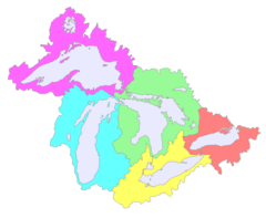
Though the five lakes lie in separate basins, they form a single, naturally interconnected body of fresh water, within the Great Lakes Basin. As a chain of lakes and rivers, they connect the east-central interior of North America to the Atlantic Ocean. From the interior to the outlet at the Saint Lawrence River, water flows from Superior to Huron and Michigan, southward to Erie, and finally northward to Lake Ontario. The lakes drain a large watershed via many rivers and contain approximately 35,000 islands.[12] There are also several thousand smaller lakes, often called "inland lakes", within the basin.[13]
The surface area of the five primary lakes combined is roughly equal to the size of the United Kingdom, while the surface area of the entire basin (the lakes and the land they drain) is about the size of the UK and France combined.[14] Lake Michigan is the only one of the Great Lakes that is entirely within the United States; the others form a water boundary between the United States and Canada. The lakes are divided among the jurisdictions of the Canadian province of Ontario and the U.S. states of Michigan, Wisconsin, Minnesota, Illinois, Indiana, Ohio, Pennsylvania, and New York. Both the province of Ontario and the state of Michigan include in their boundaries portions of four of the lakes: The province of Ontario does not border Lake Michigan, and the state of Michigan does not border Lake Ontario. New York and Wisconsin's jurisdictions extend into two lakes, and each of the remaining states into one of the lakes.

