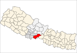
| Nawalparāsī Jillā नवलपरासी जिल्ला | |
|---|---|
 | |
| País | |
| Admin HQ. | Ramgram |
| Gobierno | |
| • Tipo | Comité de coordinación |
| • Cuerpo | DCC , Nawalparāsī Jillā नवलपरासी जिल्ला |
| Área | |
| • Total | 2,162 km 2 (835 millas cuadradas) |
| Zona horaria | UTC + 05: 45 ( NPT ) |
| Codigo telefonico | 078 |
| Idioma principal | Nepalí , Tharu , Bhojpuri, Urdu |
El distrito de Nawalparasi ( nepalí : नवलपरासी जिल्ला , pronunciado [nʌwʌlpʌˈɾasi] ( escuchar )![]() ) parte del cual pertenece a Gandaki Pradesh y parte a la provincia de Lumbini , era uno de los setenta y cinco distritos de Nepal antes de ser dividido. El distrito, con Ramgram como su sede del distrito, cubría un área de 2,162 kilómetros cuadrados (835 millas cuadradas) y tiene una población (2011) de 643,508.
) parte del cual pertenece a Gandaki Pradesh y parte a la provincia de Lumbini , era uno de los setenta y cinco distritos de Nepal antes de ser dividido. El distrito, con Ramgram como su sede del distrito, cubría un área de 2,162 kilómetros cuadrados (835 millas cuadradas) y tiene una población (2011) de 643,508.
Este distrito ha dado a luz a muchas personas de alto nivel de Nepal, incluido el difunto Primer Ministro Tanka Prasad Acharya . El punto medio de la autopista de este a oeste de Nepal, la autopista Mahendra, se encuentra en este distrito. El valle de Nawalpur es la parte del gran valle de Chitwan de terai interior donde la mayoría de las poblaciones son tharu, magar y brahmanes que se asentaron migrando desde las colinas. Las grandes industrias como Chaudhary Udhyog Gram (CUG), la fábrica de pulpa y papel Bhrikuti están ubicadas en el área de Nawalpur de este distrito. Dado que Parasi es la sede del distrito de Nawalparasi, muchas de las oficinas administrativas se encuentran allí. Una de las fábricas de azúcar más grandes de Nepal, Lumbini Sugar Industry, que fue hecha con el apoyo de China, también se encuentra en Sunwal. Municipality of this district. Nowadays many industries are also being operated here like Sarbottam Cement factory, Butwal cement factory, Triveni distillery, cement factory of CG in Dumkibas, Jamuwad paper factory and other cottage industries. Developing cities such as Devchuli Municipality, Gaindakot Municipality, Kawasoti Municipality Sunwal Municipality, Madhyabindu Municipality and Bardaghat Municipality are located here. Famous towns in Nawalpur Ragion are Gaindakot, Rajahar, Keurani, Pragatinagar, Kawasoti, Shahid nagar Danda, Chormara, Arungkhola etc. Half of the Nawalpur Region is mainly hilly areas mainly populated by Brahmins, Magar and Chhetri people and terai area is mainly populated by Tharu people.
Nawalparasi district is connected to Rupandehi District on the west, Palpa and Tanahun Districts on the north, Chitwan District on the east and south and the Indian border. The longest road of Mahendra highway, 99 km in length, lies in this district. Major cities of Nepal such as Butwal, Siddharthanagar, Tansen and Bharatpur metropolitan municipality are located in neighbouring districts
Geography and Climate[edit]
The highest peak in Nepal's Churia range, Mt. Devchuli 1,937 metres (6,355 ft), is in this district.
| Climate Zone[1] | Elevation Range | % of Area |
|---|---|---|
| Lower Tropical | below 300 meters (1,000 ft) | 56.2% |
| Upper Tropical | 300 to 1,000 meters 1,000 to 3,300 ft. | 34.9% |
| Subtropical | 1,000 to 2,000 meters 3,300 to 6,600 ft. | 5.7% |
Demographics[edit]
At the time of the 2011 Nepal census, Nawalparasi District had a population of 643,508. Of these, 40.9% spoke Nepali, 29.0% Bhojpuri, 13.6% Magar, 9.8% Tharu, 1.9% Maithili, 1.5% Gurung, 1.0% Newari and 0.6% Tamang as their first language.[2]
Village Development Committees (VDCs) and Municipalities in Nawalparasi[edit]
- Amraut
- Badahara Dubauliya
- Baidauli
- Banjariya
- Bardaghat Municipality
- Benimanipur
- Bharatipur
- Bhujhawa
- Bulingtar
- Dadajheri Tadi
- Dawanne Devi
- Dedgaun
- Deurali
- Devachuli Municipality
- Devagawa
- Dhobadi
- Dhurkot
- Dumkibas
- Gaidakot Municipality
- Germi
- Guthi Parsauni
- Guthisuryapura
- Hakui
- Harpur
- Hupsekot
- Jahada, Lumbini
- Jamuniya
- Jamuwad
- Jaubari
- Kawasoti Municipality
- Kolhuwa
- Kotathar
- Kudiya
- Kumarwarti
- Kusma
- Madhyabindu Municipality
- Mainaghat
- Manari
- Manjhariya
- Mithukaram
- Naram
- Narsahi
- Naya Belhani
- Pakalihawa
- Palhi
- Ramgram Municipality
- Parsauni
- Pratappur
- Rajahar
- Rakachuli
- Rakuwa
- Ramgram Municipality
- Ramnagar
- Rampur Khadauna
- Rampurwa
- Ratnapur
- Ruchang
- Rupauliya
- Saidnagar Danda
- Sanai
- Sarawal
- Somani
- Sukrauli
- Sunwal Municipality
- Suryapura
- Swathi
- Tamasariya
- Thulo Khairatawa
- Tilakpur
- Tribenisusta
- Unwach
- Upallo Arkhale
See also[edit]
°Center for Development and Disaster management (CDM-Nepal) is a leading non-governmental development and humanitarian organisation of Lumbini Province of Nepal. Established in 2000 in Butwal, CDM-Nepal has worked in DRM, CCA, WASH, livelihood and GBV. CDM-Nepal
- Industry of nawalparasi
References[edit]
- ^ The Map of Potential Vegetation of Nepal - a forestry/agroecological/biodiversity classification system (PDF), Forest & Landscape Development and Environment Series 2-2005 and CFC-TIS Document Series No.110., 2005, ISBN 87-7903-210-9, retrieved Nov 22, 2013
- ^ 2011 Nepal Census, Social Characteristics Tables
- "Districts of Nepal". Statoids.
| Wikimedia Commons has media related to Nawalparasi District. |
Coordinates: 27°32′N 83°40′E / 27.533°N 83.667°E / 27.533; 83.667