
Los Estados Unidos de América fueron creados el 4 de julio de 1776, con la Declaración de Independencia de trece colonias británicas en América del Norte . En la Resolución Lee del 2 de julio de 1776, las colonias resolvieron que eran estados libres e independientes. La unión se formalizó en los Artículos de Confederación , que entraron en vigor el 1 de marzo de 1781, después de ser ratificado por los 13 estados. Su independencia fue reconocida por Gran Bretaña en el Tratado de París de 1783, que concluyó la Guerra Revolucionaria Americana.. Esto duplicó efectivamente el tamaño de las colonias, ahora capaces de extenderse hacia el oeste más allá de la Línea de Proclamación hasta el río Mississippi . Esta tierra se organizó en territorios y luego en estados, aunque persistió algún conflicto con las concesiones de mar a mar reclamadas por algunas de las colonias originales. Con el tiempo, estas subvenciones fueron cedidas al gobierno federal.
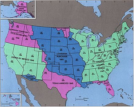
La primera gran expansión del país se produjo con la Compra de Luisiana de 1803, que duplicó el territorio del país, aunque la frontera sureste con la Florida española fue objeto de mucha disputa hasta que ésta y las reclamaciones españolas sobre el país de Oregón fueron cedidas a Estados Unidos en 1821. El país de Oregon le dio a los Estados Unidos acceso al Océano Pacífico , aunque fue compartido por un tiempo con el Reino Unido . [1] La anexión de la República de Texas en 1845 condujo directamente a la Guerra México-Estadounidense , después de la cual los victoriosos Estados Unidos obtuvieron la mitad norte de México.territorio, incluido lo que rápidamente se convirtió en el estado de California . [2] Sin embargo, a medida que el desarrollo del país se movía hacia el oeste, la cuestión de la esclavitud se volvió más importante, con un vigoroso debate sobre si los nuevos territorios permitirían la esclavitud y eventos como el Compromiso de Missouri y Bleeding Kansas . Esto llegó a un punto crítico en 1860 y 1861, cuando los gobiernos de los estados del sur proclamaron su secesión del país y formaron los Estados Confederados de América . La Guerra Civil estadounidense llevó a la derrota de la Confederación en 1865 y a la eventual readmisión de los estados al Congreso de los Estados Unidos.. La creencia cultural en el destino manifiesto de los Estados Unidos proporcionó un fuerte ímpetu para la expansión hacia el oeste en el siglo XIX.
La expansión del país más allá de América del Norte comenzó en 1856 con la aprobación de la Ley de las Islas del Guano , lo que provocó la reclamación de muchas islas pequeñas y deshabitadas, pero económicamente importantes, en el Océano Pacífico y el Mar Caribe . [3] La mayoría de estos reclamos fueron finalmente abandonados debido a reclamos en competencia de otros países o al guano que se extrajo. La expansión del Pacífico culminó con la anexión de Hawai en 1898, después del derrocamiento de su gobierno cinco años antes. Alaska , la última gran adquisición en América del Norte, fue comprada a Rusia en 1867.
El apoyo a la independencia de Cuba del Imperio español y el hundimiento del USS Maine condujeron a la Guerra Hispanoamericana en 1898, en la que Estados Unidos ganó Guam , Puerto Rico y Filipinas y ocupó Cuba durante varios años. . Samoa Americana fue adquirida por Estados Unidos en 1900 después del final de la Segunda Guerra Civil de Samoa . [4] Estados Unidos compró las Islas Vírgenes Estadounidenses a Dinamarca en 1917. [5]Guam y Puerto Rico siguen siendo territorios; Filipinas se independizó en 1946, después de ser un escenario importante de la Segunda Guerra Mundial . Después de la guerra, muchas islas fueron confiadas a los Estados Unidos por las Naciones Unidas , [6] y mientras las Islas Marianas del Norte siguen siendo un territorio de los Estados Unidos , las Islas Marshall , los Estados Federados de Micronesia y Palau emergieron del territorio fiduciario como naciones independientes. El último gran cambio internacional fue la adquisición en 1904 y el regreso a Panamá en 1979 de la Zona del Canal de Panamá., un territorio estadounidense no incorporado que controlaba el Canal de Panamá . La cesión final del control formal sobre la región se hizo a Panamá en 1999.
Con respecto a las fronteras internas, aunque los territorios podrían cambiar enormemente de tamaño, una vez establecidos los estados generalmente han conservado sus fronteras iniciales. Sólo cuatro estados , Maine , Kentucky , Vermont y West Virginia, se han creado a partir de tierras reclamadas por otro estado; todos los demás fueron creados a partir de territorios o directamente de adquisiciones. Cuatro estados — Luisiana , Misuri , Nevada y Pensilvania — se han expandido significativamente al adquirir territorio federal adicional después de su admisión inicial a la Unión. El último estado de los Estados Unidos contiguos, comúnmente llamado el "48 inferior", fue admitido en 1912; el quincuagésimo y más reciente estado fue admitido en 1959.
Leyenda para mapas [ editar ]
- Clave para los colores del mapa
- Estados de Estados Unidos (mapas nacionales), área indiscutible de Estados Unidos (mapas de disputa)
- Territorios de Estados Unidos (mapas nacionales)
- área en disputa de Estados Unidos
- área cambiada por evento
1776-1784 (Revolución americana) [ editar ]
| Fecha | Evento | Cambiar mapa |
|---|---|---|
| 2 de julio de 1776 y 4 de julio de 1776 | Trece colonias del Reino de Gran Bretaña en América del Norte declararon colectivamente su independencia como los Estados Unidos de América, [a] aunque varias colonias ya habían declarado individualmente su independencia: [7]
La capital no fue establecida específicamente; en ese momento, el Congreso Continental se reunió en Filadelfia . [24] [25] Muchos estados tenían fronteras vagamente definidas e inspeccionadas; estos no se anotan como impugnados en los mapas a menos que haya una disputa activa. Las fronteras de Carolina del Norte estaban particularmente mal estudiadas, su frontera con Carolina del Sur se había hecho en varias partes, ninguna de las cuales coincidía realmente con el espíritu de la carta, [26] [27] y su frontera con Virginia solo se inspeccionó aproximadamente a la mitad del interior. del mar. Varios estados del noreste tenían reclamos superpuestos: Connecticut, la bahía de Massachusetts y Nueva York reclamaron tierras al oeste de sus fronteras aceptadas, superponiéndose entre sí y con un reclamo considerable de Virginia. De los tres, solo Connecticut persiguió seriamente sus reclamos, mientras que se considera que Virginia tuvo el reclamo más legítimo sobre el vasto noroeste, dividiéndolo en condados y manteniendo un control limitado. Gran Bretaña reclamó la totalidad de los nuevos Estados Unidos, incluidas Machias Seal Island y North Rock , dos pequeñas islas frente a la costa noreste que permanecen en disputa hasta el presente. [28] | Disputas: |
| 20 de septiembre de 1776 | Los condados de New Castle, Kent y Sussex, en Delaware, promulgaron una constitución , rebautizándose como Estado de Delaware . [29] | |
| 28 de septiembre de 1776 | El estado de Pennsylvania promulgó una constitución , renombrándose a sí mismo como Commonwealth of Pennsylvania . [30] | sin cambios en el mapa |
| 20 de diciembre de 1776 | Para evitar las fuerzas británicas que avanzaban sobre Filadelfia , el Congreso Continental comenzó a reunirse en Baltimore . [24] [25] | |
| 15 de enero de 1777 | La región noreste de Nueva York , conocida como New Hampshire Grants , declaró su independencia como New Connecticut . [31] [32] [33] | Disputas: |
| 4 de marzo de 1777 | El Congreso Continental regresó a Filadelfia después de que terminó la amenaza de las fuerzas británicas . [24] [25] | |
| 4 de junio de 1777 | New Connecticut pasó a llamarse Vermont . [33] [31] | Disputas: |
| 27 de septiembre de 1777 | El Congreso Continental huyó de Filadelfia después de la derrota estadounidense en la Batalla de Brandywine y se reunió brevemente en Lancaster, Pensilvania [24] [25] | |
| 30 de septiembre de 1777 | El Congreso Continental continuó alejándose de Filadelfia , instalándose en York, Pensilvania . [24] [25] | |
| 11 de junio de 1778 | Vermont reclamó lo que se llamó "East Union", que consta de algunas ciudades de New Hampshire que solicitaron el 12 de marzo de 1778 unirse a Vermont debido a la preocupación de que su estado se estaba centrando demasiado en su región costera. Vermont nunca obtuvo el control total sobre el área. [31] [34] [35] [36] [b] | Disputas: |
| 21 de octubre de 1778 | Debido a la presión del Congreso Continental , Vermont rescindió la anexión de East Union; la legislatura declaró el 12 de febrero de 1779 que la Unión del Este debía considerarse nula desde su inicio. [34] [35] [36] | Disputas: |
| 2 de julio de 1779 | El Congreso Continental regresó a Filadelfia tras la retirada británica . [24] [25] | |
| 31 de agosto de 1779 | Virginia cedió su derecho al suroeste de Pensilvania . [19] [37] | |
| Marzo 1780 | Carolina del Norte y Virginia inspeccionaron su frontera hacia el interior. La prospección de Virginia llegó al río Tennessee , pero la de Carolina del Norte solo llegó hasta Cumberland Gap , y como las dos prospecciones estaban separadas aproximadamente a dos millas, esto creó un área delgada reclamada por ambos estados. Si bien se pretendía que la frontera siguiera los 36 ° 30 ′ al norte , los primeros errores topográficos hicieron que se desviara hacia el norte, alcanzando una distancia de diecisiete millas cuando llegó al río Tennessee. [38] [23] | |
| 25 de octubre de 1780 | El estado de la bahía de Massachusetts promulgó una constitución , renombrándose como Commonwealth of Massachusetts . | |
| 1 de marzo de 1781 | Los Artículos de Confederación entraron en vigor. [39] | sin cambios en el mapa |
| 4 de abril de 1781 | Vermont reclamó nuevamente una Unión del Este, que consistía en algunas ciudades de New Hampshire que deseaban unirse a Vermont; Se interesaron más ciudades que durante el primer intento en 1778, aunque nuevamente, se desconoce la extensión exacta de las fronteras. Vermont nunca obtuvo el control total sobre el área. [31] [40] [35] [36] [c] | Disputas: |
| 16 de junio de 1781 | Vermont reclamó lo que se llamó la "Unión del Oeste", que consta de algunas ciudades de Nueva York , principalmente para contrarrestar el intento de Vermont de expansión hacia el este. Vermont nunca obtuvo el control total sobre el área. [31] [35] [41] [42] La fecha específica en que esto ocurrió no está clara; las fuentes sugieren el 16 de junio, el 26 de junio y el 18 de julio. [d] | Disputas: |
| 22 de febrero de 1782 | Vermont abandonó sus intentos de anexar la East Union de New Hampshire y la West Union de Nueva York . [31] [36] [42] [43] | Disputas: |
| 29 de octubre de 1782 | El gobierno federal aceptó la cesión de Nueva York de sus pretensiones occidentales, que el estado cedió el 17 de febrero de 1780; Nueva York proclamó que su nueva frontera occidental sería una línea trazada al sur desde el extremo occidental del lago Ontario . En su interpretación máxima, el estado había reclamado un área delimitada por el lago Erie , el lago Huron y el lago Michigan ; a los ríos Illinois , Mississippi y Tennessee ; y al norte a lo largo de las Montañas Apalaches , terminando en la frontera con Pensilvania . [44]No está claro de dónde vino esta afirmación; muchas fuentes afirman que Nueva York lo había entregado, pero muy pocas explican cómo se obtuvo. Una fuente afirma que fue una cesión de las Seis Naciones , que habían conquistado gran parte de la región. [45] Sin embargo, Nueva York nunca hizo cumplir seriamente estas afirmaciones. La cesión incluyó la pequeña punta de Nueva York al norte de Pensilvania, que llegó a conocerse como el Triángulo de Erie . [46] [17] | |
| 30 de diciembre de 1782 | El Congreso de la Confederación declaró que la tierra que Connecticut reclamó en el norte de Pensilvania era parte de Pensilvania, intentando así poner fin a la Guerra Pennamite-Yankee . [47] [19] La afirmación era una extensión de las fronteras más al norte y más al sur de Connecticut hacia el oeste, saltando Nueva Jersey y Nueva York , aunque como la frontera norte de Connecticut estaba a unas pocas millas al norte de la frontera norte de Pensilvania , una pequeña franja de Nueva York estaba también reclamó. Si bien el conflicto continuaría durante algún tiempo, este fue el final del reclamo formal de Connecticut. | |
| 30 de junio de 1783 | El motín de Pensilvania de 1783 , y la reacción del gobierno de Pensilvania al mismo, hicieron que el Congreso de la Confederación abandonara Filadelfia hacia Princeton . [24] | |
| 26 de noviembre de 1783 | El Congreso de la Confederación volvió a reunirse en Annapolis . [24] | |
| 1 de marzo de 1784 | Virginia cedió sus reclamos al noroeste del río Ohio al gobierno federal. [48] [23] Connecticut continuó reclamando sus tierras occidentales que se habían superpuesto a la cesión de Virginia. | |
| 12 de mayo de 1784 | Gran Bretaña reconoció la independencia de Estados Unidos, poniendo fin a su reclamo sobre el país. [49] [50] [e] El tratado puso fin a la Guerra Revolucionaria Estadounidense , aunque la acción militar había terminado en gran medida después de la victoria franco-estadounidense en Yorktown el 19 de octubre de 1781. Debido a las ambigüedades y el escaso conocimiento de la geografía, el tratado no fue claro en varias áreas:
La Paz de París también implicó tratados con Francia y España , con Gran Bretaña cediendo las Floridas a España . Durante su propiedad de Florida Occidental , los británicos habían trasladado su frontera al norte, y la cesión a España parecía aplicarse en toda la extensión de la colonia británica. Sin embargo, el tratado británico-estadounidense concedió la extensión de Florida Occidental a los Estados Unidos, donde amplió Georgia al sur a 31 ° norte , lo que indica que solo la definición original de Florida Occidental iba a ser cedida a España. Los gobernadores españoles locales también hicieron un movimiento para ocupar fuertes a lo largo del río Mississippi., con reclamos sobre todo al sur del río Tennessee ; se desconoce cuán oficiales o fuertes fueron estas afirmaciones, y no están mapeadas ya que están en conflicto con la otra reclamación española relacionada con la frontera de Florida Occidental. [51] | Disputas: |
1784–1803 (Organización del territorio) [ editar ]
| Fecha | Evento | Cambiar mapa |
|---|---|---|
| 23 de agosto de 1784 | Una región en el centro de Carolina del Norte (actual Tennessee del este ), descontenta con el gobierno del estado sobre el área, declaró su independencia del estado como el Estado de Frankland . [f] [52] El gobierno de Frankland tenía cierto control sobre el área y solicitó la estadidad, recibiendo el apoyo de siete de los nueve estados requeridos, pero solo duraría unos pocos años. [53] [54] | Cambio no oficial: |
| 1 de noviembre de 1784 | El Congreso de la Confederación se trasladó por un corto tiempo a Trenton . [24] | |
| 11 de enero de 1785 | El Congreso de la Confederación se trasladó a Nueva York y se instalaría allí durante cinco años. [24] | |
| 19 de abril de 1785 | El gobierno federal aceptó la cesión de Massachusetts de su reclamo del extremo occidental, que nunca se hizo cumplir seriamente. [g] [44] [13] | Cambiar solo en papel: |
| Junio 1785 | El estado de Frankland pasó a llamarse Estado de Franklin , para alentar a Benjamin Franklin a respaldar el estado, aunque se negó. [53] | Cambio no oficial: |
| 13 de septiembre de 1786 | Connecticut entregó su reclamo occidental al gobierno federal a excepción de su Reserva Occidental , aunque no está claro cuánto control tenían sobre la región cedida. [h] [8] [55] | Cambiar solo en papel: |
| 16 de diciembre de 1786 | Massachusetts cedió su reclamo sobre el oeste de Nueva York , aunque no está claro si Massachusetts alguna vez tuvo control sobre la región, ya que el reclamo era sobre el "suelo, no la soberanía". [i] [44] [13] Esta tierra se conoció más tarde como la Compra de Phelps y Gorham . | Cambiar solo en papel: |
| 13 de julio de 1787 | El Territorio al noroeste del río Ohio , cedido anteriormente por Virginia , se organizó y se conoció comúnmente como el Territorio del Noroeste . [56] [57] | |
| 9 de agosto de 1787 | Carolina del Sur cedió su reclamo occidental al gobierno federal, [58] [22] aunque fue el resultado de una geografía inexacta y Carolina del Sur nunca tuvo un reclamo sobre esta tierra. El reclamo era de una franja de tierra entre la frontera de Carolina del Norte y la fuente del río Tugaloo pero, desconocido en ese momento, el río se originó en Carolina del Norte. La parte oriental de esta cesión se entregaría a Georgia en 1802, a pesar de que, técnicamente, Georgia ya tenía derecho a la tierra. | Cambiar solo en papel: |
| 7 de diciembre de 1787 | Delaware se convirtió en el primer estado en ratificar la Constitución de los Estados Unidos . [59] | sin cambios en el mapa |
| 12 de diciembre de 1787 | Pensilvania se convirtió en el segundo estado en ratificar la Constitución . [60] | sin cambios en el mapa |
| 18 de diciembre de 1787 | Nueva Jersey se convirtió en el tercer estado en ratificar la Constitución . [61] | sin cambios en el mapa |
| 2 de enero de 1788 | Georgia se convirtió en el cuarto estado en ratificar la Constitución . [62] | sin cambios en el mapa |
| 6 de enero de 1788 | Connecticut se convirtió en el quinto estado en ratificar la Constitución . [63] | sin cambios en el mapa |
| 6 de febrero de 1788 | Massachusetts se convirtió en el sexto estado en ratificar la Constitución . [64] | sin cambios en el mapa |
| 28 de abril de 1788 | Maryland se convirtió en el séptimo estado en ratificar la Constitución . [sesenta y cinco] | sin cambios en el mapa |
| 23 de mayo de 1788 | Carolina del Sur se convirtió en el octavo estado en ratificar la Constitución . [66] | sin cambios en el mapa |
| 21 de junio de 1788 | New Hampshire se convirtió en el noveno estado en ratificar la Constitución ; [67] en este punto, la Constitución se convirtió en el documento de gobierno activo de los nueve estados que la ratificaron (según el artículo VII ). | sin cambios en el mapa |
| 25 de junio de 1788 | Virginia se convirtió en el décimo estado en ratificar la Constitución . [68] | sin cambios en el mapa |
| 26 de julio de 1788 | Nueva York se convirtió en el undécimo estado en ratificar la Constitución . [69] | sin cambios en el mapa |
| Febrero 1789 | John Sevier , gobernador del estado de Franklin , juró lealtad a Carolina del Norte , poniendo fin de manera efectiva a la pretendida independencia de Franklin. [53] [70] | Cambio no oficial: |
| 7 de agosto de 1789 | El Territorio del Noroeste fue reorganizado bajo la Constitución . [71] | sin cambios en el mapa |
| 21 de noviembre de 1789 | Carolina del Norte se convirtió en el duodécimo estado en ratificar la Constitución . [72] | sin cambios en el mapa |
| 2 de abril de 1790 | Carolina del Norte cedió su mitad occidental al gobierno federal. [j] [73] [54] | |
| 26 de mayo de 1790 | La tierra cedida recientemente por Carolina del Norte se organizó como el Territorio al Sur del río Ohio, comúnmente conocido como el Territorio del Suroeste . [54] [74] | |
| 29 de mayo de 1790 | Rhode Island se convirtió en el decimotercer estado en ratificar la Constitución . [75] | sin cambios en el mapa |
| 6 de diciembre de 1790 | Según la Ley de Residencia , el Congreso de los Estados Unidos se trasladó a Filadelfia durante diez años hasta que se construyó y estuvo listo un distrito federal . [24] [25] [76] | |
| 4 de marzo de 1791 | Vermont , que se había considerado parte de Nueva York a pesar de actuar de forma independiente desde 1777, fue admitido como el decimocuarto estado. [k] [31] [77] | Disputas: |
| 30 de marzo de 1791 | El Distrito de Columbia , un distrito federal planeado para albergar al gobierno federal en 1800, se formó a partir de tierras cedidas por Maryland y Virginia , [78] [79] que consta de un diamante de 100 millas cuadradas, con su extremo sur en Jones Point , a caballo entre el río Potomac. Sin embargo, aún no se le ha dado ese nombre, simplemente se le conoce como distrito federal. En septiembre de 1791, los comisionados a cargo de la planificación de la ciudad lo llamarían el "Territorio de Columbia", y varias leyes se refieren a un Distrito de Columbia, pero a veces de manera informal. El área no parece haber sido nombrada formalmente "Distrito de Columbia" hasta al menos la ley orgánica de 1871 . [80] Dado que el nombre "Columbia" se usó desde muy temprano, y al menos informalmente por el gobierno, el mapa usará "Distrito de Columbia" a partir de esta fecha. | |
| 3 de marzo de 1792 | Pensilvania compró el Erie Triangle al gobierno federal. [19] | |
| 1 de junio de 1792 | La mitad occidental de Virginia , que el estado había acordado en 1789 ceder al gobierno federal, [81] fue admitida como el decimoquinto estado, Kentucky . [l] [83] [82] | |
| 12 de junio de 1792 | El estado de Delaware promulgó una nueva constitución , renombrándose a sí mismo como el estado de Delaware . [84] | sin cambios en el mapa |
| 3 de agosto de 1795 | Los representantes de los Estados Unidos y la Confederación Occidental firman el Tratado de Greenville , que pone fin a la Guerra Indígena del Noroeste y ceden la mayor parte del estado moderno de Ohio al control de los Estados Unidos. [85] | sin cambios en el mapa |
| 29 de febrero de 1796 | Gran Bretaña acordó abandonar varios fuertes en el noroeste que todavía ocupaba, incluido Detroit . El Tratado de Jay también preveía comisiones para determinar la frontera entre el punto noroeste del lago de los bosques y la fuente del río Mississippi , y qué río considerar el río St. Croix . [86] | sin cambios en el mapa |
| 25 de abril de 1796 | La mitad norte de Florida Occidental fue cedida por España , resolviendo la disputa sobre la región. [87] [88] | Disputas: |
| 1 de junio de 1796 | El Territorio del Sudoeste fue admitido como el decimosexto estado, Tennessee . [54] [89] | |
| 7 de abril de 1798 | Debido al Fraude Terrestre de Yazoo , una ley autorizó al presidente John Adams a nombrar comisionados para negociar con Georgia sobre la cesión de sus tierras occidentales. La ley creó el Territorio de Mississippi a partir del cuarto suroeste de Georgia en la región cedida recientemente por West Florida , al tiempo que mantiene que Georgia todavía tiene derechos sobre el territorio. [90] [91] | |
| 25 de octubre de 1798 | Los comisionados acordaron sobre la fuente del río St. Croix , estableciendo la parte inferior de la frontera entre Massachusetts y Gran Bretaña y, por lo tanto, donde se originó la línea este norte-sur. [92] | Disputas: |
| 9 de junio de 1800 | Connecticut cedió su Reserva Occidental al gobierno federal, que la asignó al Territorio del Noroeste . [93] La ley que lo hizo fue aprobada en el Congreso el 28 de abril de 1800 y Connecticut la aprobó en esta fecha. [94] | |
| 4 de julio de 1800 | El Territorio de Indiana se organizó a partir de la mitad occidental del Territorio del Noroeste . [m] [96] [95] | |
| 17 de noviembre de 1800 | El Congreso de los Estados Unidos se trasladó a Washington en el Distrito de Columbia , ahora construido y listo para ser la capital. [24] Esto fue dos semanas antes de la fecha del 1 de diciembre establecida en la Ley de Residencia ; El presidente John Adams instó al Congreso a actuar temprano con la esperanza de obtener suficientes votos sureños para ser reelegido, aunque fracasó. [97] | |
| 1 de enero de 1801 | El Reino de Gran Bretaña se unió al Reino de Irlanda y pasó a llamarse Reino Unido . [98] | |
| 27 de febrero de 1801 | El Distrito de Columbia fue organizado . [79] [99] | sin cambios en el mapa |
| 26 de abril de 1802 | Georgia cedió su mitad occidental, conocida como las Tierras de Yazoo , al gobierno federal. [n] Al mismo tiempo, el gobierno federal cedió a Georgia la parte oriental de la tierra cedida anteriormente por Carolina del Sur , aunque en realidad Georgia ya tenía técnicamente el título de propiedad de la tierra, ya que la descripción de la cesión anterior se basó en un error comprensión de la geografía. [11] | |
| 1 de marzo de 1803 | La mitad sur del Territorio del Noroeste , junto con una fina franja del Territorio de Indiana , fue admitida como el decimoséptimo estado, Ohio . El resto del Territorio del Noroeste se transfirió al Territorio de Indiana. [100] [56] La frontera occidental era una línea hacia el norte desde la desembocadura del Gran Río Miami ; la definición federal de la frontera norte era una línea trazada hacia el este desde el extremo sur del lago Michigan , mientras que la Constitución de Ohio establecía que la línea debía correr desde el extremo sur del lago Michigan hasta el cabo más al norte de la bahía de Maumee , esencialmente el extremo occidental de Lago Erie. La confusión causada por estas descripciones variables de las fronteras del estado, combinada con un conocimiento inexacto de la geografía, ya que nadie en ese momento sabía qué tan lejos se extendía al sur del lago Michigan, conduciría al conflicto sobre la Franja de Toledo . | |
| 3 de noviembre de 1803 | La frontera entre Tennessee y Virginia fue reexaminada y establecida, poniendo fin a la disputa sobre esa parte de la frontera. La frontera entre Kentucky y Tennessee , a pesar de seguir la encuesta original, permaneció vagamente definida. [38] [101] |
1803-1818 (compra de Luisiana) [ editar ]
| Fecha | Evento | Cambiar mapa |
|---|---|---|
| 20 de diciembre de 1803 | Estados Unidos compró Luisiana a Francia . Ésta es la fecha del cambio formal en Nueva Orleans ; la compra se completó el 30 de abril de 1803. [102] La transferencia se reconocería en St. Louis en la Alta Luisiana el 10 de marzo de 1804, conocido como el Día de las Tres Banderas . La adquisición expandió los Estados Unidos a la totalidad de la cuenca del río Mississippi , [o] pero la extensión de lo que constituía Luisiana en el sur fue disputada con España : Estados Unidos afirmó que la compra incluía la parte de Florida occidental al oeste del río Perdido , mientras que España afirmó que terminaba en la frontera occidental de Florida occidental; [p] [103] y la frontera suroeste con Nueva España fue disputada , ya que Estados Unidos reclamó el río Sabine como frontera, pero España mantuvo que era el río Calcasieu y otros. [102] | Disputas: |
| 1804 | El " Southwick Jog " fue transferido de Connecticut a Massachusetts , para poner fin a los viejos desacuerdos sobre la frontera entre los dos estados. [13] | |
| 27 de marzo de 1804 | La tierra entre Tennessee y el Territorio de Mississippi cedida previamente por Georgia fue asignada al Territorio de Mississippi. [91] [104] | |
| 1 de octubre de 1804 | El Territorio de Orleans se organizó a partir de la Compra de Luisiana al sur de 33 ° norte , y el resto se designó como Distrito de Luisiana y se colocó bajo la jurisdicción del Territorio de Indiana . [105] [106] | |
| 30 de junio de 1805 | El Territorio de Michigan se organizó desde el Territorio de Indiana , al norte de una línea al este desde el extremo sur del lago Michigan , y al este de una línea al norte desde el extremo norte del lago. [107] [108] La parte sureste de la frontera técnicamente entraba en conflicto con la definición de Ohio , que reclamaba la Franja de Toledo al norte de esa línea; sin embargo, aún no se conocía la posición exacta del lago Michigan. | |
| 4 de julio de 1805 | El Distrito de Luisiana se organizó como Territorio de Luisiana . [106] [109] | |
| 1 de marzo de 1809 | El Territorio de Illinois se organizó a partir de la mitad occidental del Territorio de Indiana . [q] [111] [110] | |
| 26 de septiembre de 1810 | La República de Florida Occidental declaró su independencia de España , reclamando el área de Florida Occidental al oeste del río Perdido . Mantuvo cierto control sobre su territorio. [112] | Disputas: |
| 10 de diciembre de 1810 | Las fuerzas armadas dirigidas por William CC Claiborne tomaron posesión de la parte del oeste de Florida al oeste del río Pearl , luego de una proclamación el 27 de octubre de 1810 del presidente James Madison para hacerlo. Estados Unidos había considerado la región como parte de la Compra de Luisiana , incluida la zona que se había rebelado contra la Florida española y había formado la República de Florida Occidental . La proclamación de Madison declaró que debía ser "tomado como parte" del Territorio de Orleans . [103] [102] [113] La tierra al oeste de Mobile Bay hasta el río Pearl fue ocupada y anexada de factopor los militares en 1811. [114] : 2a ( mapa ) | Disputas: |
| 30 de abril de 1812 | La mayor parte del territorio de Orleans fue admitida como el decimoctavo estado, Louisiana . [r] [106] [115] El resto del sureste presumiblemente se convirtió en territorio desorganizado, ya que no tuvo definición por un corto tiempo. | |
| 14 de mayo de 1812 | La parte reclamada del oeste de Florida al este del río Pearl se asignó al territorio de Mississippi , aunque el área alrededor de Mobile Bay permaneció bajo el control de la Florida española . [91] [116] Los Estados Unidos ocuparon militarmente Mobile y el área circundante hasta el río Perdido en abril de 1813. | |
| 4 de junio de 1812 | Dado que su nombre ahora se comparte con el estado de Louisiana , el Territorio de Louisiana pasó a llamarse Territorio de Missouri . [117] [118] | |
| 4 de agosto de 1812 | La porción restante reclamada de West Florida , al oeste del río Pearl , se agregó a Louisiana , tras el consentimiento de ese estado a una ley aprobada por el Congreso el 14 de abril de 1812. [119] [120] | |
| 16 de agosto de 1812 | Durante la Guerra de 1812 , la guarnición de Fort Detroit se rindió , lo que llevó al Reino Unido a ocupar Detroit , la capital y centro de población del Territorio de Michigan . [121] | Disputas: |
| 29 de septiembre de 1813 | Fort Detroit fue recapturado por las fuerzas estadounidenses después de la batalla del lago Erie , recuperando el control sobre el territorio de Michigan . [121] [122] | Disputas: |
| 24 de agosto de 1814 | Las fuerzas británicas capturan y queman Washington , pero se ven obligadas a retirarse al día siguiente. Las funciones de la capital solo se suspendieron momentáneamente, aunque el presidente James Madison se refugió en Brookville, Maryland . [123] | sin cambios en el mapa |
| 11 de diciembre de 1816 | La parte sur del Territorio de Indiana , junto con pequeñas partes del Territorio de Illinois y el Territorio de Michigan , fueron admitidas como el decimonoveno estado, Indiana . [s] El resto del territorio de Indiana a través del lago Michigan se convirtió en territorio desorganizado. [95] [124] | |
| 3 de marzo de 1817 | El Territorio de Alabama se organizó a partir de la mitad oriental del Territorio de Mississippi . [t] [126] [125] | |
| 10 de diciembre de 1817 | El Territorio de Mississippi fue admitido como el vigésimo estado, Mississippi . [91] [127] | |
| 6 de febrero de 1818 | El Territorio de Alabama creó el condado de Tuskaloosa con una descripción que inadvertidamente se superpuso con Mississippi . Describió la frontera del condado como "un curso hacia el oeste hacia el río Tombeckbe; desde allí el mismo hasta el puerto de Cotton Gin". [128] Desconocido en ese momento, el origen del río Tombigbee y el puerto de Cotton Gin estaban en Mississippi. | Cambiar solo en papel: |
| 30 de junio de 1818 | Según los términos del Tratado de Gante que puso fin a la guerra de 1812 , el Reino Unido devolvió la isla Moose a Massachusetts , y los Estados Unidos devolvieron la isla Campobello , la isla Deer y la isla Grand Manan al Reino Unido, todas las cuales fueron capturadas del Reino Unido. otro lado durante la guerra. [129] | sin cambios en el mapa |
| 3 de diciembre de 1818 | La mitad del territorio de Illinois al sur de los 42 ° 30 ′ de latitud norte fue admitida como el vigésimo primer estado, Illinois . El resto del territorio, junto con el territorio desorganizado que recientemente formaba parte del Territorio de Indiana , se asignó al Territorio de Michigan . [110] [130] |
1819-1845 (expansión del noroeste) [ editar ]
| Fecha | Evento | Cambiar mapa |
|---|---|---|
| 30 de enero de 1819 | El Tratado de 1818 entró en vigor, estableciendo 49 ° norte como la frontera con el Reino Unido al oeste del Lago de los Bosques , y también estableciendo el País de Oregón como una región compartida con el Reino Unido. [1] [131] [132] El país de Oregón no tenía un límite norte definido, pero se puede suponer que no invadió mucho las tierras controladas por los rusos ; este mapa usa la línea establecida más tarde a 54 ° 40 ′ norte para simplificar. | Noroeste de América del Norte: |
| 4 de julio de 1819 | El Territorio de Arkansaw se organizó a partir de la parte sur del Territorio de Missouri . [u] [133] [134] | |
| 14 de diciembre de 1819 | El Territorio de Alabama fue admitido como el vigésimo segundo estado, Alabama . [125] [135] La ley sobre la estadidad preveía una inspección de la parte sur de la frontera con Mississippi , que estaba destinada a ser de norte a sur, para realizar ajustes si se descubría que invadía los condados establecidos de Mississippi; más tarde se descubrió que lo hacía. | |
| 15 de marzo de 1820 | Como parte del Compromiso de Missouri , el Distrito de Maine , la parte norte y separada de Massachusetts , fue admitido como el vigésimo tercer estado, Maine . [136] [137] | |
| 21 de abril de 1820 | Esta es la fecha más antigua conocida en la que el nombre " Territorio de Arkansas " se utiliza oficialmente en lugar de "Territorio de Arkansas". [138] | |
| 12 de mayo de 1820 | Se estableció la frontera entre Kentucky y Tennessee . Para compensar el hecho de que la frontera entre Cumberland Gap y el río Tennessee se desvió hacia el norte hasta 17 millas desde 36 ° 30 ′ norte , se realizó una nueva encuesta comenzando en esa latitud en el río Mississippi y moviéndose hacia el este hasta Tennessee. River, garantizando así que este último trozo de frontera encajaría en el ideal original. [38] | |
| 19 de julio de 1820 | La superposición de la frontera sur longitudinal entre Alabama y Mississippi se resolvió, según la ley que admite a Alabama como estado, porque la frontera provisional invadió Mississippi. [125] [139] Como resultado de una encuesta, el término de la frontera sur se movió aproximadamente 3,8 millas al este, lo que cambió la frontera hasta la esquina entonces noroeste del condado de Washington de Alabama. La fecha en que sucedió esto no está clara; las fuentes disponibles dan un informe inédito fechado el 29 de mayo de 1820 o la finalización de la demarcación de la nueva línea el 19 de julio de 1820. | Cambiar solo en papel: |
| 19 de diciembre de 1820 | Alabama redefinió algunas fronteras del condado, poniendo fin a su superposición errónea de Mississippi creada el 6 de febrero de 1818. [140] | Cambiar solo en papel: |
| 22 de febrero de 1821 | El Tratado de Adams-Onís con España entró en vigor. [103] Los muchos cambios incluyeron:
| Disputas: |
| 10 de julio de 1821 | El este de Florida fue transferido formalmente a los Estados Unidos por España . [141] | |
| 17 de julio de 1821 | West Florida fue transferido formalmente a los Estados Unidos por España . [141] | |
| 10 de agosto de 1821 | La esquina sureste del Territorio de Missouri fue admitida como el vigésimo cuarto estado, Missouri , y el resto se convirtió en territorio desorganizado. [w] [118] [142] | |
| 30 de marzo de 1822 | La antigua Florida Oriental y Florida Occidental se organizaron como Territorio de Florida . [143] [144] | |
| 26 de mayo de 1824 | La mitad del Territorio de Arkansas al oeste de una línea al sur desde un punto a 40 millas al oeste de la frontera occidental de Missouri fue devuelta a territorio desorganizado. [134] [145] | |
| 12 de enero de 1825 | Un tratado con el Imperio Ruso estableció 54 ° 40 ′ al norte como la frontera norte del país de Oregon para propósitos estadounidenses; un tratado separado creó la misma frontera entre Rusia y el Reino Unido . [146] Como de todos modos esta era probablemente la frontera de facto , la región ya está mapeada con esta línea. | sin cambios en el mapa |
| 6 de mayo de 1828 | Un tratado con Cherokee movió la frontera occidental del Territorio de Arkansas , devolviendo parte de ella a territorio desorganizado. [x] [134] [148] | |
| 20 de enero de 1831 | El rey Guillermo I de los Países Bajos , habiendo sido solicitado por el Tratado de Gante para arbitrar la disputada frontera entre Maine y el Reino Unido , tomó su decisión: Dado que reconciliar el tratado con los mapas dados era demasiado difícil, trazó una línea de compromiso. El gobierno británico lo aceptó, pero Maine protestó y el 19 de enero de 1832 el gobierno estadounidense lo rechazó. [149] | sin cambios en el mapa |
| 9 de julio de 1832 | La región de New Hampshire al norte de los lagos de Connecticut , que se disputaba con el Reino Unido , declaró su independencia como República de Indian Stream . [150] Aunque es pequeño, parece haber mantenido cierto control sobre su territorio. | Disputas: |
| 28 de junio de 1834 | El Territorio de Michigan ganó una gran parcela de tierra del territorio desorganizado, extendiéndose hacia el oeste hasta el río Missouri y el río White Earth . [108] [151] | |
| 5 de agosto de 1835 | La República de Indian Stream reconoció la jurisdicción de New Hampshire , poniendo así fin a su pretendida independencia. La fecha indicada corresponde a una comunicación enviada a las autoridades británicas ; [152] otras fuentes señalan una resolución aprobada por los ciudadanos de Indian Stream el 2 de abril de 1836. [150] | Disputas: |
| 15 de junio de 1836 | El Territorio de Arkansas fue admitido como el vigésimo quinto estado, Arkansas . [134] [153] | |
| 3 de julio de 1836 | El Territorio de Wisconsin se organizó a partir de la mayor parte occidental del Territorio de Michigan . [y] [154] [155] Las dos grandes penínsulas entre los Grandes Lagos permanecieron en el Territorio de Michigan; la península superior se incluyó a cambio de que el territorio abandonara su derecho a la Franja de Toledo . El territorio inicialmente rechazó este plan, pero lo aceptaría el 14 de diciembre. | |
| 14 de diciembre de 1836 | El Territorio de Michigan acordó abandonar su reclamo sobre Toledo Strip , poniendo fin a su disputa con Ohio . [156] | |
| 26 de enero de 1837 | El Territorio de Michigan fue admitido como el vigésimo sexto estado, Michigan . [108] [157] | |
| 28 de marzo de 1837 | La Compra de Platte transfirió algunas tierras de un territorio desorganizado al noroeste de Missouri , extendiendo su frontera norte hacia el oeste hasta el río Missouri . [118] [158] | |
| 3 de julio de 1838 | El Territorio de Iowa se organizó desde el Territorio de Wisconsin al oeste del río Mississippi . [159] [160] | |
| 11 de febrero de 1839 | Missouri reclamó un área al norte de su frontera con el Territorio de Iowa , iniciando la larga disputa conocida como la Guerra de la Miel . [161] | |
| 21 de mayo de 1840 | Las encuestas realizadas a lo largo de la frontera con Texas concluyeron que el área reclamada por Arkansas para el condado de Miller pertenecía a Texas. [162] | |
| 10 de noviembre de 1842 | El Tratado Webster-Ashburton definió la frontera con el Reino Unido al este de las Montañas Rocosas . [163] [164] Una fuente también lo menciona alterando muy levemente el límite marítimo entre Michigan y el territorio de Wisconsin. [165] El tratado resolvió las disputas sobre las fronteras norteñas de Maine y New Hampshire , [z] la frontera noreste del Territorio de Wisconsin , [aa] y Sugar Island con Michigan . La frontera entre Nueva York y Vermont por un lado, y el Reino Unido por el otro, fue aclarada por el tratado. En 1816, se inició la construcción de un fuerte sin nombre apodado " Fort Blunder " en una península en el lago Champlain que, aunque al sur de la frontera examinada, se descubrió que estaba al norte de 45 ° norte , que era la frontera establecida por el Tratado de París y así en territorio británico. En consecuencia, se abandonó la construcción del fuerte. El Tratado Webster-Ashburton especificaba que la sección de la frontera debía seguir la línea encuestada, en lugar del paralelo exacto, moviendo así el área del fuerte a los Estados Unidos y un nuevo fuerte, Fort Montgomery., se construiría en el lugar en 1844. [167] Como se examinó la línea anterior, aunque no coincidía con la definición, se consideró que era la frontera legítima. | Disputas: |
| 5 de julio de 1843 | Los colonos locales crearon un gobierno provisional para Oregon Country . Si bien no es oficial, mantuvo cierta jurisdicción sobre el área. [168] | Cambio no oficial: Noroeste de América del Norte: |
| 3 de marzo de 1845 | El Territorio de Florida fue admitido como el vigésimo séptimo estado, Florida . [144] [169] |
1845-1860 (expansión suroeste) [ editar ]
| Fecha | Evento | Cambiar mapa |
|---|---|---|
| 29 de diciembre de 1845 | La República de Texas fue anexada y admitida como el vigésimo octavo estado, Texas , extendiendo el suroeste de los Estados Unidos hasta el Río Grande . [170] [171] Todo Texas fue reclamado por México . Si bien muchas fuentes afirman que México reconoció la independencia de la parte oriental de Texas, los tratados fueron rechazados por el gobierno mexicano. Texas entregó formalmente la soberanía a los Estados Unidos en una ceremonia el 19 de febrero de 1846. [172] La anexión condujo al comienzo de la Guerra México-Estadounidense unos meses más tarde. [172] | Disputas: |
| 15 de junio de 1846 | El Tratado de Oregón estableció 49 ° al noroeste del lago de los bosques como frontera continental (por lo que no incluía la isla de Vancouver ) con tierras en manos del Reino Unido . El reparto de Oregon Country terminó y la parte de Estados Unidos se convirtió en territorio desorganizado. [173] El tratado era vago sobre qué estrecho debía ser la frontera entre la isla de Vancouver y el continente, lo que provocó una disputa sobre la propiedad de las islas de San Juan . [174] Especificó "a través de la mitad de dicho canal y del Estrecho de Fuca, hasta el Océano Pacífico". | Noroeste de América del Norte: Controversias: |
| 22 de septiembre de 1846 | Tras la captura el 18 de agosto de 1846 de Santa Fe , capital del territorio mexicano de Santa Fe de Nuevo México , [175] se creó un código de leyes conocido como Código Kearny para la zona. [176] [177] La región se superpuso con el reclamo de Texas , aunque Texas tenía poco o ningún control sobre el área fuera de su barrio este. | Cambio no oficial: |
| 28 de diciembre de 1846 | La parte del territorio de Iowa al sur de los 43 ° 30 ′ al norte y al este del río Big Sioux fue admitida como el vigésimo noveno estado, Iowa . El resto se convirtió en territorio desorganizado. [160] [178] | |
| 13 de marzo de 1847 | El Distrito de Columbia retrocedió al condado de Alexandria de regreso a Virginia . [79] El Congreso aprobó la ley el 9 de julio de 1846, [179] los residentes del condado de Alexandria fueron proclamados por el presidente que la habían aceptado el 7 de septiembre de 1846, [180] y Virginia tomó posesión de la tierra en esta fecha. [181] | |
| 29 de mayo de 1848 | La mayor parte del sur del territorio de Wisconsin fue admitida como el trigésimo estado, Wisconsin . [ab] El resto se convirtió en territorio desorganizado. [155] [182] Sin embargo, los ciudadanos del resto decidieron continuar con un gobierno civil, e incluso eligieron a un delegado a la Cámara de Representantes de los Estados Unidos que se sentaría el 15 de enero de 1849, esencialmente haciendo de esta región una de continuación de facto del Territorio de Wisconsin. [183] | |
| 4 de julio de 1848 | El Tratado de Guadalupe Hidalgo puso fin a la guerra entre México y Estados Unidos y cedió una gran parcela de tierra de México , que consta de sus territorios de Alta California y Santa Fe de Nuevo México , y su reclamo sobre Texas . [ac] [185] Debido a un desacuerdo sobre la frontera sur de Santa Fe de Nuevo México, se inició una disputa fronteriza. [184] | Disputas: |
| 14 de agosto de 1848 | El Territorio de Oregón se organizó a partir del territorio desorganizado que antes formaba parte del País de Oregón . [186] [187] | |
| 13 de febrero de 1849 | La disputa fronteriza entre Iowa y Missouri conocida como la Guerra de la Miel fue resuelta por la Corte Suprema de los Estados Unidos . La frontera resultante fue la Línea Sullivan que existía antes de la disputa, dividiendo aproximadamente las dos reclamaciones. [188] | |
| 3 de marzo de 1849 | El Territorio de Minnesota se organizó a partir de la región que había estado operando como Territorio de Wisconsin de facto y territorio desorganizado al este de los ríos Missouri y White Earth . [189] [166] | |
| 12 de marzo de 1849 | Un gobierno local formó el estado de Deseret y reclamó una gran parte del suroeste, incluida la mayor parte de la Cesión mexicana . Aunque solicitó ser admitido en los Estados Unidos, la propuesta fue rechazada y, en 1850, se formó el Territorio de Utah . [190] El área reclamada se superpuso ligeramente con el área reclamada de Texas , así como parte del Territorio de Oregon . | Cambio no oficial: |
| 24 de noviembre de 1849 | Texas , con el consentimiento del Congreso de los Estados Unidos, [191] extendió su frontera con Luisiana desde la orilla occidental del río Sabine hasta la mitad del río. [191] [192] [193] [194] | sin cambios en el mapa |
| 9 de septiembre de 1850 | La parte occidental de la Cesión Mexicana fue admitida como el trigésimo primer estado, California . [ad] [2] [195] La porción del resto al norte de 37 ° al norte y al oeste de la cumbre de las Montañas Rocosas se organizó como Territorio de Utah . [196] [197] Parte del territorio de Utah se superponía con la parte de Texas que se compraría el 13 de diciembre de 1850, pero la ley que autoriza la compra se aprobó ese día, por lo que las fronteras del territorio de Utah asumieron que la compra pasará . | |
| 9 de diciembre de 1850 | El Reino Unido cedió menos de un acre de roca submarina conocida como Horseshoe Reef en el lago Erie cerca de Buffalo, Nueva York, para un faro. Estaba rodeado por aguas británicas, creando así una forma de enclave. [198] | |
| 13 de diciembre de 1850 | El gobierno federal compró los reclamos occidentales de Texas . [ae] [171] El Territorio de Nuevo México se organizó a partir de la parte de esta tierra al este del Río Grande , junto con el resto del territorio desorganizado de la Cesión Mexicana . [af] [200] [199] El Territorio de Nuevo México incluía toda el área que había sido gobernada bajo el Código Kearny . | |
| 5 de abril de 1851 | El Estado de Deseret se disolvió, sus funciones y territorio en gran parte fueron reemplazados por el Territorio de Utah . [201] | Cambio no oficial: |
| 2 de marzo de 1853 | El Territorio de Washington se organizó a partir de la mitad del Territorio de Oregon al norte de 46 ° norte y el río Columbia . [202] [203] | |
| 30 de mayo de 1854 | El Territorio de Kansas se organizó a partir de un territorio desorganizado al norte de 37 ° norte , y el Territorio de Nebraska se organizó al norte de 40 ° norte . [204] [205] [206] Gran parte del territorio desorganizado restante, al este de los 100 ° oeste , se conoció como Territorio Indio , designado como un lugar para reasentar tribus indias. Una pequeña franja entre el Panhandle de Texas y el Territorio de Kansas no fue reclamada, debido a la caída al sur de la frontera del Territorio de Kansas pero al norte de 36 ° 30 ′ de norte establecido en el Compromiso de Missouri como el límite norte de la esclavitud, y por lo tanto Texas no podía tenerlo. Esto se conoció como la Franja de Tierras Públicas o, a veces, "Tierra de Nadie". [207] | |
| 30 de junio de 1854 | Estados Unidos compró una gran parcela de México conocida como la Compra de Gadsden , ya que ofrecía una ruta mucho mejor para un ferrocarril transcontinental del sur. [ag] [208] [209] Esto resolvió la disputa fronteriza, ya que la tierra en disputa se incluyó en la compra. [184] | Disputas: |
| 4 de agosto de 1854 | La compra de Gadsden obtenida recientemente se asignó al territorio de Nuevo México . [199] [210] | |
| 11 de enero de 1855 | Debido a su inaccesibilidad del resto del estado, Boston Corner fue trasladado de Massachusetts a Nueva York . [211] [212] [213] | |
| 6 de marzo de 1855 | La Corte Suprema falló a favor de Florida en una disputa fronteriza con Georgia , estableciendo la línea fronteriza estatal a lo largo de la línea de McNeil . [214] | sin cambios en el mapa |
| 28 de octubre de 1856 | Baker Island y Jarvis Island fueron reclamadas bajo la Ley de Islas Guano . [3] | Océano Pacífico: |
| 11 de mayo de 1858 | La mitad oriental del territorio de Minnesota fue admitida como el trigésimo segundo estado, Minnesota . [ah] El resto se convirtió en territorio desorganizado. [166] [215] | |
| 31 de agosto de 1858 | La isla de Navassa se reclamó en virtud de la Ley de las Islas Guano . [3] | Mar Caribe: |
| 3 de diciembre de 1858 | Howland Island fue reclamada bajo la Ley de Islas Guano . [3] | Océano Pacífico: |
| 14 de febrero de 1859 | La mitad occidental del Territorio de Oregon fue admitida como el trigésimo tercer estado, Oregon . [ai] El resto se transfirió al territorio de Washington . [187] [216] | |
| 6 de julio de 1859 | Un equipo de topógrafos creó el "Middleton Offset", una pequeña muesca en la frontera entre Kentucky y Tennessee . Se desconoce exactamente por qué se hizo esto, aunque una teoría es que un terrateniente local quería su propiedad en Tennessee. [217] [218] | |
| 6 de septiembre de 1859 | Johnston Atoll fue reclamado bajo la Ley de Islas Guano , [3] aunque había sido reclamado por Hawai en 1858. [219] | Océano Pacífico: |
| 7 de noviembre de 1859 | Se estableció un gobierno local que abarcaba partes de los territorios de Kansas , Nebraska , Nuevo México , Utah y Washington , con el nombre de Territorio de Jefferson . [aj] Aunque nunca fue reconocido por el gobierno federal, generalmente mantuvo el control sobre el área hasta que se estableció el Territorio de Colorado , que adoptó la mayoría de sus leyes. [220] | Cambio no oficial: |
| 27 de diciembre de 1859 | Isla Enderbury , Isla McKean , Phoenix Island y la isla de Starbuck fueron reclamados en virtud de la Ley de islas guaneras . [3] | Océano Pacífico: |
| 29 de diciembre de 1859 | La isla Christmas y la isla Malden fueron reclamadas en virtud de la Ley de las Islas Guano . [3] | Océano Pacífico: |
| 8 de febrero de 1860 | Texas creó el condado de Greer , reclamando parte del territorio indio basado en un entendimiento diferente del gobierno federal de qué bifurcación del río Rojo era la frontera entre los dos. [221] Atafu , Isla Birnie , Butaritari , Isla Caroline , Isla Fanning , Isla Flint , Isla Gardner , Isla de Cantón , el arrecife Kingman , Manihiki , Marakei , Nukunono , Atolón Palmyra , Penrhyn , Pukapuka , Rakahanga , Isla de Swain , Island Sidney , Isla Vostok , y La isla de Washington fue reclamada bajo la Ley de Islas Guano .[3] Muchas islas adicionales se enumeraron como unidas en esta fecha, pero según las coordenadas eran fantasmas o duplicados. Además,se reclamó la isla Sarah Ann , que pudo haber existido y sería vista hasta 1917, pero que desde entonces ha desaparecido. [222] | Océano Pacífico: |
1860-1865 (Guerra civil) [ editar ]
| Fecha | Evento | Cambiar mapa |
|---|---|---|
| 20 de diciembre de 1860 | En respuesta a la elección de Abraham Lincoln , Carolina del Sur proclamó su secesión de la Unión, retirándose del Congreso de los Estados Unidos. [223] | Disputas: |
| 9 de enero de 1861 | Mississippi proclamó su secesión de la Unión, retirándose del Congreso. [223] | Disputas: |
| 10 de enero de 1861 | Florida proclamó su secesión de la Unión, retirándose del Congreso. [223] | Disputas: |
| 11 de enero de 1861 | Alabama proclamó su secesión de la Unión, retirándose del Congreso. [223] | Disputas: |
| 19 de enero de 1861 | Georgia proclamó su secesión de la Unión, retirándose del Congreso. [223] | Disputas: |
| 26 de enero de 1861 | Luisiana proclamó su secesión de la Unión, retirándose del Congreso. [223] Sin embargo, los distritos 1 y 2 del Congreso, alrededor de Nueva Orleans , mantuvieron representación en el Congreso. | Disputas: |
| 29 de enero de 1861 | La mayor parte del territorio de Kansas al este de 25 ° al oeste de Washington fue admitida como el trigésimo cuarto estado, Kansas . El resto se convirtió en territorio desorganizado. [205] [224] | |
| 8 de febrero de 1861 | Los Estados Confederados de América estaban formados por representantes de los estados separados de Alabama , Georgia , Florida , Luisiana , Mississippi y Carolina del Sur . [225] | Disputas: |
| 28 de febrero de 1861 | El Territorio de Colorado se organizó a partir de partes del Territorio de Nebraska , el Territorio de Nuevo México y el Territorio de Utah , junto con el territorio no organizado. [ak] [227] [226] | |
| 2 de marzo de 1861 | Texas proclamó su secesión de la Unión y fue admitida en los Estados Confederados , [223] [228] retirándose del Congreso. El Territorio de Dakota se organizó a partir del Territorio de Nebraska y el territorio no organizado al norte de él. [al] La frontera occidental del Territorio de Nebraska se trasladó a 27 ° al oeste de Washington , ganando pequeñas porciones del Territorio de Utah y el Territorio de Washington . [206] [229] [230] El Territorio de Nevada se organizó desde el Territorio de Utah al oeste de 39 ° al oeste de Washington . [231] [232] | Disputas: |
| 28 de marzo de 1861 | Los representantes en la mitad sur del Territorio de Nuevo México proclamaron un Territorio de Arizona independiente al sur de los 34 ° norte . [233] | Disputas: |
| 12 de abril de 1861 | La batalla de Fort Sumter en Carolina del Sur comienza la Guerra Civil estadounidense . | Disputas: |
| 17 de abril de 1861 | Después de la Batalla de Fort Sumter y el presidente Abraham Lincoln 's llamado a las tropas para responder , Virginia proclamó su secesión de la Unión, la retirada del Congreso. [223] Sin embargo, los distritos congresionales 1º (a lo largo de la costa este ), 7º (cerca de Washington, DC ) y 10º , 11º y 12º (en el noroeste del estado) mantuvieron representación en el Congreso. | Disputas: |
| 6 de mayo de 1861 | Arkansas proclamó su secesión de la Unión, retirándose del Congreso. [223] | Disputas: |
| 7 de mayo de 1861 | Virginia fue admitida en los Estados Confederados . [234] | Disputas: |
| 16 de mayo de 1861 | Kentucky se declaró neutral en la Guerra Civil estadounidense . | sin cambios en el mapa |
| 20 de mayo de 1861 | Arkansas fue admitida en los Estados Confederados . [235] Carolina del Norte proclamó su secesión de la Unión, retirándose del Congreso. [223] | Disputas: |
| 21 de mayo de 1861 | Carolina del Norte fue admitida en los Estados Confederados . La ley que admitía al estado requería una proclamación presidencial antes de que entrara en vigencia, [236] que según las fuentes tuvo lugar en esta fecha; [237] la única fuente primaria encontrada hasta ahora es una declaración de Jefferson Davis el 20 de julio que indica que se había hecho la proclamación. [238] | Disputas: |
| 6 de junio de 1861 | Robert Williamson Steele , gobernador del Territorio de Jefferson , declaró el territorio disuelto y entregó el gobierno al primer gobernador del Territorio de Colorado . [220] | Cambio no oficial: |
| 8 de junio de 1861 | Tennessee proclamó su secesión de la Unión, retirándose del Congreso. [223] Sin embargo, los distritos 2 , 3 y 4 del Congreso en la parte central del estado mantuvieron representación en el Congreso. | Disputas: |
| 25 de junio de 1861 | El gobierno federal reconoció al Gobierno Restaurado de Virginia en Wheeling como el gobierno legítimo de Virginia . [239] | |
| 2 de julio de 1861 | Tennessee fue admitido en los Estados Confederados . [240] | Disputas: |
| 1 de agosto de 1861 | Tras la victoria confederada en la Primera Batalla de Mesilla , el Territorio de Arizona fue proclamado como parte de los Estados Confederados . [241] | Disputas: |
| 13 de septiembre de 1861 | Tras la ocupación confederada de Columbus , Kentucky , el 3 de septiembre de 1861, el estado abandonó la neutralidad y se alineó con el gobierno de la Unión. [242] | sin cambios en el mapa |
| 31 de octubre de 1861 | Un gobierno escindido en Neosho, Missouri , declaró la secesión del estado de Estados Unidos. [223] | Disputas: |
| 20 de noviembre de 1861 | Una convención en Russellville, Kentucky , declaró la formación de un gobierno escindido en Bowling Green y la secesión de Kentucky de los Estados Unidos. [223] | Disputas: |
| 28 de noviembre de 1861 | El gobierno escindido de Neosho de Missouri fue admitido en los Estados Confederados . Los estados confederados nunca tuvieron mucho poder sobre el estado, pero se le dio plena representación en la legislatura. [243] | Disputas: |
| 10 de diciembre de 1861 | El gobierno disidente de Bowling Green de Kentucky fue admitido en los Estados Confederados . Los estados confederados nunca tuvieron mucho poder sobre el estado, pero se le dio plena representación en la legislatura. [244] | Disputas: |
| 21 de diciembre de 1861 | Los Estados Confederados ratificaron tratados con Osage , Seneca y Shawnee . [245] [246] | Disputas: |
| 23 de diciembre de 1861 | Los Estados Confederados ratificaron tratados con Cherokee , otorgándoles un delegado al Congreso de los Estados Confederados , y con los Seminole , otorgándoles un delegado para ser compartido con Creek . [245] [246] | Disputas: |
| 31 de diciembre de 1861 | Los Estados Confederados ratificaron tratados con Choctaw y Chickasaw , otorgándoles un delegado en el Congreso de los Estados Confederados ; con el Comanche ; con los Creek , otorgándoles un delegado para compartir con los Seminole ; y el Quapaw . [245] [246] | Disputas: |
| 1 de marzo de 1862 | Entró en vigor un decreto de la Corte Suprema de Estados Unidos , modificando la frontera entre Massachusetts y Rhode Island . [am] [13] [247] | |
| 15 de abril de 1862 | El atolón Palmyra fue anexado por Hawái , y el reclamo estadounidense queda inactivo. [248] | Océano Pacífico: |
| 14 de julio de 1862 | La porción del Territorio de Utah al oeste de 38 ° al oeste de Washington fue transferida al Territorio de Nevada . [232] [249] | |
| 30 de diciembre de 1862 | Las Islas Swan fueron reclamadas bajo la Ley de Islas Guano . [3] | Mar Caribe: |
| 24 de febrero de 1863 | El Territorio de Arizona se organizó a partir de la mitad del Territorio de Nuevo México al oeste de 32 ° al oeste de Washington . [250] [251] | |
| 3 de marzo de 1863 | El Territorio de Idaho se organizó a partir de las partes del Territorio de Dakota y el Territorio de Nebraska al oeste de 27 ° al oeste de Washington , y la mitad del Territorio de Washington al este del río Snake y una línea al norte desde la desembocadura del río Clearwater . [252] [253] | |
| 4 de marzo de 1863 | Debido a la interrupción en la votación y la baja participación, a nadie se le permitió tomar los escaños en la Cámara de Representantes de los Estados Unidos en manos de las áreas unionistas de Louisiana , Tennessee y Virginia , expulsando efectivamente a los estados. [254] | |
| 20 de junio de 1863 | Los condados del noroeste de Virginia , representados por el Gobierno Restaurado de Virginia en Wheeling , se separaron del resto de Virginia y fueron admitidos en la Unión como el trigésimo quinto estado, Virginia Occidental . [an] [256] [255] El Gobierno Restaurado de Virginia fue trasladado a Alejandría . | |
| 5 de agosto de 1863 | El condado de Berkeley fue transferido por el gobierno federal de Virginia a Virginia Occidental . [257] | |
| 2 de noviembre de 1863 | El condado de Jefferson fue trasladado de Virginia a Virginia Occidental . [258] | |
| 26 de mayo de 1864 | El Territorio de Montana se organizó desde el tercio noreste del Territorio de Idaho , [ao] y el tercio sureste del Territorio de Idaho se transfirió al Territorio de Dakota . [ap] [259] [230] [260] | |
| 15 de octubre de 1864 | Malden Island fue reclamada por el Reino Unido . [261] | Océano Pacífico: |
| 31 de octubre de 1864 | El Territorio de Nevada fue admitido como el trigésimo sexto estado, Nevada . [232] [262] | |
| 5 de mayo de 1865 | El gabinete de los Estados Confederados se reunió en Washington, Georgia y se disolvió. [263] Las rendiciones militares se esparcieron a lo largo de 1865, pero se considera que la más importante fue la del Ejército de Virginia del Norte después de la Batalla de Appomattox Court House el 9 de abril. | Disputas: |
1866–1897 (Reconstrucción y estadidad occidental) [ editar ]
| Fecha | Evento | Cambiar mapa |
|---|---|---|
| 5 de mayo de 1866 | La porción del Territorio de Utah al oeste de 37 ° al oeste de Washington fue transferida a Nevada . [264] | |
| 24 de julio de 1866 | Tennessee fue readmitido en el Congreso. [265] | |
| 26 de diciembre de 1866 | La isla Starbuck fue reclamada por el Reino Unido . [261] | Océano Pacífico: |
| 18 de enero de 1867 | La esquina noroeste del territorio de Arizona , al oeste del río Colorado y 37 ° al oeste de Washington , fue transferida a Nevada . La ley que transfiere la tierra fue aprobada el 5 de mayo de 1866, pero a diferencia de la transferencia del Territorio de Utah de ese día, esta transferencia dependía de que el estado la aceptara. [264] [266] | |
| 1 de marzo de 1867 | El Territorio de Nebraska fue admitido como el trigésimo séptimo estado, Nebraska . [206] [267] | |
| 1 de julio de 1867 | Canadá se formó a partir de varias colonias británicas, incluida Nueva Brunswick , heredando así la disputa sobre Machias Seal Island y North Rock . | Disputas: |
| 28 de agosto de 1867 | Se reclamó el atolón de Midway . [268] La isla más grande de Midway, Sand Island, había sido reclamada bajo la Ley de Islas Guano en 1858, pero no se sabe nada más sobre esto. [269] | Océano Pacífico: |
| 18 de octubre de 1867 | Alaska fue comprada al Imperio Ruso y designada Departamento de Alaska . [aq] [271] [272] Debido a una descripción vaga y la falta de un levantamiento de calidad, la frontera sureste con las propiedades británicas no estaba clara y estaba en disputa . [270] | Noroeste de América del Norte: |
| 22 de junio de 1868 | Arkansas fue readmitido en el Congreso. [273] | |
| 25 de junio de 1868 | Florida fue readmitida en el Congreso. [274] | |
| 4 de julio de 1868 | Carolina del Norte fue readmitida en el Congreso. [275] | |
| 9 de julio de 1868 | Luisiana y Carolina del Sur fueron readmitidas en el Congreso. [276] Caroline Island fue reclamada por el Reino Unido . [261] | Océano Pacífico: |
| 13 de julio de 1868 | Alabama fue readmitida en el Congreso. [277] | |
| 25 de julio de 1868 | Georgia fue readmitida en el Congreso. [278] El Territorio de Wyoming se organizó a partir de partes de los Territorios de Dakota , Idaho y Utah . [ar] [280] [279] El territorio permanecería bajo la jurisdicción del Territorio de Dakota hasta que se organizara su propio gobierno el 19 de mayo de 1869. [281] La ley que organiza el Territorio de Wyoming se convirtió en ley en esta fecha, pero no está claro si el territorio podía considerarse "organizado" hasta el 19 de mayo de 1869, como especifica la ley, no entraría en vigor hasta que se organice un gobierno; sin embargo, todas las fuentes usan esta fecha como la creación, y la mayoría la usan para la organización, del territorio. Una pequeña porcióndel Territorio de Dakota se dejó atrás por error en el lado occidental del Territorio de Wyoming. [282] | |
| 12 de agosto de 1868 | La lista de reclamaciones de islas guano consolidadas menciona "Islas en el Mar Caribe sin nombre" consolidadas en esta fecha, pero se desconoce a qué se refiere. [3] | sin cambios en el mapa |
| 11 de diciembre de 1868 | Serrana Bank fue reclamado en virtud de la Ley de las Islas Guano . [3] Colombia lo ha reclamado a lo largo de su historia. | Mar Caribe: |
| 3 de marzo de 1869 | Georgia fue nuevamente expulsada del Congreso luego de los fracasos de la Reconstrucción en el estado. [283] | |
| 22 de noviembre de 1869 | Bajo Nuevo Bank , Pedro Cays , Quita Sueño Bank y Roncador Bank fueron reclamados bajo la Ley de las Islas Guano . [3] [268] A excepción de los Cayos Pedro, Colombia los ha reclamado a lo largo de su historia. | Mar Caribe: |
| 26 de enero de 1870 | Virginia fue readmitida en el Congreso. [284] | |
| 23 de febrero de 1870 | Mississippi fue readmitido en el Congreso. [285] | |
| 30 de marzo de 1870 | Texas fue readmitido en el Congreso. [286] | |
| 15 de julio de 1870 | Georgia fue readmitida nuevamente en el Congreso. [287] El Territorio Noroeste fue transferido por el Reino Unido a Canadá , transfiriendo así su parte de la disputa fronteriza de Alaska . [288] | Noroeste de América del Norte: |
| 9 de febrero de 1871 | Una pequeña parcela fue transferida del Territorio de Dakota a Nebraska luego de un cambio repentino en el curso del río Missouri . [206] [289] | |
| 20 de julio de 1871 | Columbia Británica se unió a Canadá , transfiriendo la disputa sobre las Islas San Juan, así como su parte de la disputa fronteriza de Alaska . [290] | Disputas: Noroeste de América del Norte: |
| 21 de octubre de 1872 | La disputa con Canadá por las islas San Juan se resolvió a favor del reclamo de Estados Unidos. [174] | Disputas: |
| 1873 | La isla de Vostok fue reclamada por el Reino Unido . [291] | Océano Pacífico: |
| 17 de febrero de 1873 | La pequeña parte del Territorio de Dakota que quedó atrás cuando se creó el Territorio de Wyoming se transfirió al Territorio de Montana . [282] [292] | |
| 1 de agosto de 1876 | El Territorio de Colorado fue admitido como el trigésimo octavo estado, Colorado . [226] [293] | |
| 13 de agosto de 1877 | El Reino Unido creó los Territorios Británicos del Pacífico Occidental , incluidos Atafu y Nukunono . [294] | Océano Pacífico: |
| 3 de marzo de 1879 | La frontera a través de la Bahía de Chesapeake entre Maryland y Virginia se decidió mediante arbitraje. Se desconoce si alguna tierra realmente cambió de manos. [12] | demasiado vago para mapear |
| 8 de septiembre de 1879 | Cayo Arenas , reclamado por México ; los Cayos Morant ; y Serranilla Bank , reclamados por Colombia , fueron reclamados por los Estados Unidos en virtud de la Ley de las Islas del Guano ; [3] según la Oficina de Asuntos Insulares, el Banco Serranilla fue reclamado nuevamente el 13 de septiembre de 1880. [268] | Mar Caribe: |
| 7 de abril de 1880 | Un área muy pequeña de Fair Haven, Vermont fue transferida a Nueva York debido a un cambio en el curso del río Poultney . [31] [295] | demasiado pequeño para mapear |
| 13 de septiembre de 1880 | Western Triangle Island , reclamada por México , fue reclamada por los Estados Unidos bajo la Ley de las Islas Guano . [3] La lista de reclamaciones vinculadas también menciona una isla "De Anes" reclamada en esta fecha, con coordenadas que coinciden con Isla de Aves ; sin embargo, la misma lista señala que la reclamación de "Isla Aves" se consideró inválida. | Mar Caribe: |
| 1881 | Flint Island fue reclamada por el Reino Unido . [296] | Océano Pacífico: |
| 23 de mayo de 1882 | El área entre 43 ° norte y los ríos Keya Paha y Niobrara fue transferida del Territorio de Dakota a Nebraska . [230] [297] La ley fue aprobada en el Congreso el 28 de marzo y aceptada por la legislatura de Nebraska en esta fecha. [298] | |
| 1 de junio de 1882 | Los Cayos Morant y Cayos Pedro fueron anexados por el Reino Unido a Jamaica ; parece que los Estados Unidos ya no los reclamaron después de esto. [299] | Mar Caribe: |
| 17 de mayo de 1884 | El Departamento de Alaska se organizó en el Distrito de Alaska . [300] | Noroeste de América del Norte: |
| 21 de junio de 1884 | Las Islas Alacrans , reclamadas por México , fueron reclamadas bajo la Ley de Islas Guano . [3] | Mar Caribe: |
| 15 de marzo de 1888 | Fanning Island fue anexada por el Reino Unido ; parece que los Estados Unidos ya no reclamaron la isla después de esto. [301] | Océano Pacífico: |
| 17 de marzo de 1888 | La Isla de Navidad fue reclamada por el Reino Unido . [261] | Océano Pacífico: |
| 26 de octubre de 1888 | Las Islas Cook se convirtieron en un protectorado del Reino Unido , iniciando así un reclamo sobre los atolones de Pukapuka , Manihiki , Penrhyn y Rakahanga . [261] | Océano Pacífico: |
| 29 de mayo de 1889 | La isla de Washington fue anexada por el Reino Unido ; parece que los Estados Unidos ya no reclamaron la isla después de esto. [301] | Océano Pacífico: |
| 3 de junio de 1889 | La isla Jarvis fue reclamada por el Reino Unido . [261] | Océano Pacífico: |
| 26 de junio de 1889 | La isla de Sydney fue reclamada por el Reino Unido . [261] | Océano Pacífico: |
| 29 de junio de 1889 | La isla de Phoenix fue reclamada por el Reino Unido . [261] | Océano Pacífico: |
| 10 de julio de 1889 | Birnie Island fue reclamada por el Reino Unido . [261] | Océano Pacífico: |
| 2 de noviembre de 1889 | El Territorio de Dakota se dividió por la mitad a lo largo del "séptimo norte paralelo estándar", unas pocas millas al sur de los 46 ° norte , y se admitió como el trigésimo noveno estado, Dakota del Norte , y el cuadragésimo estado, Dakota del Sur . [230] [302] | |
| 8 de noviembre de 1889 | El Territorio de Montana fue admitido como el cuadragésimo primer estado, Montana . [259] [302] | |
| 11 de noviembre de 1889 | El Territorio de Washington fue admitido como el estado cuadragésimo segundo, Washington . [203] [302] | |
| 2 de mayo de 1890 | El Territorio de Oklahoma se organizó a partir de Public Land Strip y la mitad occidental del Territorio Indio , a excepción del Cherokee Outlet , que se agregaría más tarde tras la cesión del Cherokee . [como] [304] [303] | |
| 3 de julio de 1890 | El Territorio de Idaho fue admitido como el cuadragésimo tercer estado, Idaho . [253] [305] | |
| 10 de julio de 1890 | El Territorio de Wyoming fue admitido como el cuadragésimo cuarto estado, Wyoming . [279] [306] | |
| 8 de marzo de 1892 | Las Islas Gilbert se convirtieron en un protectorado del Reino Unido , iniciando así un reclamo sobre Butaritari y Marakei . [261] No existe ningún registro de una reclamación de los Estados Unidos después de este punto, por lo que se supone que fue entonces cuando la reclamación quedó inactiva. | Océano Pacífico: |
| 28 de mayo de 1892 | La isla Gardner fue reclamada por el Reino Unido . [261] | Océano Pacífico: |
| 16 de septiembre de 1893 | Según un tratado con Cherokee , el gobierno federal compró Cherokee Outlet en el Territorio Indio y lo abrió al asentamiento, transfiriéndolo al Territorio de Oklahoma según lo dispuesto en la Ley Orgánica de Oklahoma . [303] [307] | |
| 17 de noviembre de 1894 | Las islas Alacrans , Arenas Key y Western Triangle Island fueron eliminadas de la lista de islas de guano reclamadas . [3] | Mar Caribe: |
| 4 de enero de 1896 | El Territorio de Utah fue admitido como el cuadragésimo quinto estado, Utah . [197] [308] | |
| 16 de marzo de 1896 | La disputa entre el gobierno federal, en nombre del Territorio de Oklahoma , y Texas sobre el condado de Greer se resolvió a favor del reclamo federal. [221] | |
| 24 de julio de 1897 | Debido a un cambio anterior en el curso del río Missouri , se transfirió una isla de Nebraska a Dakota del Sur . [309] |
1898-1945 (expansión del Pacífico y el Caribe) [ editar ]
| Fecha | Evento | Cambiar mapa |
|---|---|---|
| 12 de agosto de 1898 | La República de Hawai fue anexada. [310] La ceremonia de transferencia de soberanía se produjo en esta fecha; la ley se firmó el 7 de julio de 1898. [311] El atolón Johnston no se incluyó en Hawái, ni el atolón Sikaiana , que había sido cedido a Hawái en 1856 por sus residentes y aprobado por el rey Kamehameha IV . Sin embargo, la anexión se basó en las islas nombradas en un informe de la Comisión Hawaiana, que omitió Sikaiana. [312] [313] | Océano Pacífico: |
| 17 de enero de 1899 | Se reclamó la isla Wake . [314] | Océano Pacífico: |
| 11 de abril de 1899 | Guam , Puerto Rico y, tras el pago acordado de 20 millones de dólares, las Filipinas fueron cedidas por España después de la Guerra Hispanoamericana . [315] Filipinas fue reclamada por la Primera República Filipina . La región cedida por Filipinas incluía la isla de Palmas , administrada por los Países Bajos . Esta superposición no se notará hasta el 21 de enero de 1906. [316] Si bien Estados Unidos ocupó Cuba por un tiempo, no fue cedida ni reclamada. | Océano Pacífico: Mar Caribe: |
| 16 de febrero de 1900 | Estados Unidos tomó posesión de las islas de Samoa al este de 171 ° oeste, según los términos del Convenio Tripartito . [317] | Océano Pacífico: |
| 19 de febrero de 1900 | Las islas de Samoa recién adquiridas se establecieron como Estación Naval, Tutuila . Incluía todas las islas otorgadas por el Convenio Tripartito , aunque la cesión formal de las islas por parte de las autoridades locales se produciría más tarde en 1900 y 1904. [317] | Océano Pacífico: |
| 12 de abril de 1900 | Puerto Rico se organizó en territorio civil. [318] | sin cambios en el mapa |
| 17 de abril de 1900 | La isla de Tutuila fue cedida formalmente a los Estados Unidos y se agregó a la Estación Naval de Tutuila . [317] [319] Como Estados Unidos ya había reclamado la isla el 19 de febrero de 1900, no se asigna ningún cambio. El tratado sería ratificado por el Congreso el 20 de febrero de 1929. | sin cambios en el mapa |
| 14 de junio de 1900 | La ex República de Hawái se organizó en territorio de Hawái . [320] [321] | Océano Pacífico: |
| 3 de marzo de 1901 | La transferencia de una pequeña franja de Bristol, Tennessee , a Bristol, Virginia , fue aprobada por el Congreso después de haber sido aprobada por ambos estados. [322] [323] La ubicación de la frontera a lo largo de Main Street (ahora State Street) entre las dos ciudades era la acera norte de la calle o en el medio de la calle; La cesión de Tennessee de la mitad norte de la calle puso fin al problema. | demasiado pequeño para mapear |
| 23 de marzo de 1901 | El presidente de la Primera República de Filipinas , Emilio Aguinaldo , fue capturado y la república se disolvió. En esta misma fecha, varias islas, Cagayan de Sulu y Sibutu entre ellas, fueron compradas a España y asignadas a Filipinas, que entonces estaba siendo gobernada como zona insular de Estados Unidos . Las fronteras especificadas en el Tratado de París de 1898 habían excluido estas islas; el nuevo tratado simplemente cedió "todas y cada una de las islas pertenecientes al archipiélago filipino". [324] [325] | Océano Pacífico: |
| 20 de octubre de 1903 | La disputa fronteriza de Alaska con Canadá se resolvió, generalmente a favor de la reclamación de Estados Unidos. [270] | Noroeste de América del Norte: |
| 10 de diciembre de 1903 | La tierra a lo largo del sur de la bahía de Guantánamo fue arrendada a perpetuidad a Cuba para su uso como base naval ; [326] El tratado entró en vigor el 23 de febrero de 1903, y el traspaso formal se produjo en esta fecha. [327] | sin cambios en el mapa |
| 4 de mayo de 1904 | Estados Unidos tomó posesión de la Zona del Canal de Panamá . En esta etapa, solo se definieron las fronteras más básicas; era una zona que rodeaba el canal a cada lado por cinco millas, pero excluía las ciudades de Colón y Ciudad de Panamá , que seguían siendo enclaves de Panamá , así como el agua para sus puertos. [328] El Tratado Hay-Bunau-Varilla que lo otorga a los Estados Unidos fue ratificado el 26 de febrero de 1904. [329] Se ratificaría un acuerdo fronterizo formal, que también otorgaba a la Zona del Canal un terreno y un faro en el noroeste de Colón. el 15 de junio de 1904. [330] [331] | Mar Caribe: |
| 16 de julio de 1904 | Las islas de Manu'a fueron cedidas formalmente a los Estados Unidos y agregadas a la Estación Naval de Tutuila . [317] Como Estados Unidos ya había reclamado las islas el 19 de febrero de 1900, no se registra ningún cambio. El tratado sería ratificado por el Congreso el 20 de febrero de 1929. | sin cambios en el mapa |
| 12 de diciembre de 1904 | El "Acuerdo Taft" se firmó con Panamá el 3 de diciembre, con una de sus secciones refinando el límite marítimo del puerto de la Ciudad de Panamá y la Zona del Canal de Panamá . [332] [333] Entró en vigor el 12 de diciembre. | sin cambios en el mapa |
| 10 de febrero de 1905 | La frontera entre Arkansas y el territorio indio se ajustó ligeramente cerca de Fort Smith, Arkansas , transfiriendo una pequeña cantidad de tierra en el lado este del río Poteau a Arkansas. [334] [335] | |
| 16 de noviembre de 1907 | El Territorio Indio y el Territorio de Oklahoma se combinaron y admitieron como el estado cuadragésimo sexto, Oklahoma . [303] [336] | |
| 11 de abril de 1908 | Un tratado de límites con el Reino Unido en nombre de Canadá redefinió las fronteras marítimas entre los Estados Unidos y Canadá. [337] Entre otros cambios, este arrecife de herradura "des-enclavado" en el lago Erie al hacer que el agua a su alrededor sea contigua con el agua en el lado estadounidense de la frontera. [198] [338] | sin cambios en el mapa |
| 1 de enero de 1909 | La nueva Constitución de Michigan incluyó algunas áreas de Wisconsin dentro de su definición de Michigan . [339] | |
| 20 de agosto de 1910 | Un tratado de límites con el Reino Unido en nombre de Canadá abordó una ligera incertidumbre en la frontera marítima en Passamaquoddy Bay entre Maine y Canadá. [340] [341] [342] La frontera se ajustó para que se extendiera al este de Pope's Folly Island, que anteriormente se encontraba en la línea fronteriza, y había sido objeto de debate durante muchos años. [343] [344] | |
| 17 de julio de 1911 | La Estación Naval de Tutuila pasó a llamarse Samoa Americana ; [345] la estación continuó operando separada de la gobernanza territorial hasta 1951. | Océano Pacífico: |
| 6 de enero de 1912 | El Territorio de Nuevo México fue admitido como el estado cuadragésimo séptimo, Nuevo México . [199] [346] | |
| 14 de febrero de 1912 | El Territorio de Arizona fue admitido como el cuadragésimo octavo estado, Arizona . [250] [347] | |
| 24 de agosto de 1912 | El Distrito de Alaska se reorganizó como Territorio de Alaska . [348] | Noroeste de América del Norte: |
| 31 de enero de 1913 | Nuevo México presentó una demanda en la Corte Suprema contra Texas por la " Disputa del Country Club ", cuestionando si el curso actual o el curso de 1850 del Río Grande debería ser su frontera. [349] | |
| 5 de agosto de 1914 | Las Islas del Maíz fueron arrendadas a Nicaragua por un período de 99 años ; sin embargo, esta no fue una transferencia total de soberanía y las islas nunca fueron administradas como un área insular. [350] | sin cambios en el mapa |
| 1 de mayo de 1915 | Los límites de la Zona del Canal de Panamá se definieron explícitamente. Mientras que la definición original era un corredor simple que rodeaba el canal, este tratado especificaba la frontera real. Entre los cambios que esto provocó se encuentran: se cedió una porción de la Zona del Canal a Panamá para que la Ciudad de Panamá estuviera conectada con el resto del país; la isla central de las islas Las Tres Hermanas, que marcaba la frontera con el puerto de la ciudad de Panamá, formaba parte íntegramente de la Zona del Canal; El lago Gatún y otras aguas circundantes se anexaron formalmente al territorio; y se cedió un área del noroeste de Colón a la Zona del Canal. [351] [352] [353] | Mar Caribe: |
| 27 de mayo de 1915 | En virtud del Artículo II del Tratado de 1903 , Estados Unidos expropió de Panamá varias áreas alrededor de la desembocadura del Río Chagres , anexionándolas a la Zona del Canal de Panamá . [354] | demasiado pequeño para mapear |
| 8 de diciembre de 1915 | Estados Unidos expropió a Panamá un triángulo de tierra, que incluía el histórico Fuerte San Lorenzo , entre el Río Chagres , el Mar Caribe y la Zona del Canal de Panamá , al cual estaba anexado. [354] | demasiado pequeño para mapear |
| 17 de enero de 1916 | La isla de Navassa se reclamó formalmente con fines de faro. [355] | sin cambios en el mapa |
| 31 de marzo de 1917 | Las Islas Vírgenes Danesas (excluida Water Island ) se compraron a Dinamarca [356] y se rebautizaron como Islas Vírgenes de los Estados Unidos . [357] | Mar Caribe: |
| 12 de julio de 1918 | Estados Unidos expropió a Panamá 2.6 hectáreas de terreno en Punta Paitilla en la Ciudad de Panamá y lo anexó a la Zona del Canal de Panamá . [358] Esa zona se amplió a unas 50 hectáreas en varios meses. [354] [359] [360] [361] | demasiado pequeño para mapear |
| 21 de agosto de 1918 | Estados Unidos expropió a Panamá tierras entre el Río Chagres y la Quebrada Majagual y las anexó a la Zona del Canal de Panamá . [354] [361] | Mar Caribe: |
| 13 de septiembre de 1918 | Minnesota y Wisconsin intercambiaron islas en el río Mississippi : Island Seventytwo fue transferida a Winona, Minnesota , y Barron's Island fue transferida a La Crosse, Wisconsin . [155] [362] | |
| 18 de septiembre de 1919 | La isla de Largo Remo fue anexada a la Zona del Canal de Panamá bajo el derecho de expropiación de los Estados Unidos en el Tratado del Canal de 1903. [363] | Mar Caribe: |
| 16 de junio de 1920 | Quince hectáreas de la isla de Isla Taboga fueron anexadas a la Zona del Canal de Panamá . [364] | demasiado pequeño para mapear |
| 30 de junio de 1921 | La disputa " Wedge " entre Delaware y Pennsylvania se resolvió a favor de Delaware. La tierra en disputa generalmente había sido administrada por Delaware, incluso eligiendo a un miembro de la legislatura de Delaware a mediados del siglo XIX, [365] pero los mapas federales habían incluido la tierra como parte de Pensilvania al menos hasta 1900. [366] El los estados habían acordado una resolución, y fue ratificada por una ley del Congreso en esta fecha. [367] [368] Algunas fuentes, tanto contemporáneas como modernas, señalan que, en el proceso original de volver a levantar la frontera en 1892, una región muy delgada en forma de cuerno a lo largo del arco fue transferida de Delaware a Pensilvania; [365] [368][369] sin embargo, ningún mapa federal encontrado refleja esto, y no está claro si esta transferencia realmente ocurrió. | |
| 10 de mayo de 1922 | Kingman Reef se anexó formalmente. [370] | sin cambios en el mapa |
| 8 de octubre de 1923 | Michigan expandió su reclamo al territorio de Wisconsin , aunque Wisconsin nunca perdió el control sobre el área. [339] | |
| 15 de noviembre de 1923 | Las islas de cisne fueron reclamados por Honduras . [371] | Mar Caribe: |
| 1 de febrero de 1924 | El área futura del lago Madden fue anexada a la Zona del Canal de Panamá bajo el derecho de expropiación de los Estados Unidos en el Tratado del Canal de 1903. [331] [372] [373] | Mar Caribe: |
| 4 de marzo de 1925 | La isla Swains se agregó a Samoa Americana . [374] | Océano Pacífico: |
| 17 de julio de 1925 | La frontera con Canadá se ajustó en varios lugares. [375] [376] El único cambio a una frontera terrestre redefinió cómo se debe considerar la frontera entre el Lago de los Bosques y las Montañas Rocosas ; anteriormente, la frontera seguía la curva del paralelo entre cada monumento fronterizo, mientras que el tratado cambiaba esto a líneas rectas entre cada monumento. A través de esto, Estados Unidos obtuvo una ganancia de entre 30 y 35 acres de tierra. Debido al cambio extremadamente pequeño, la falta de documentación específica de dónde ocurrieron los cambios y la falta de impacto humano, este cambio no está mapeado. También hubo un cambio en la frontera en el lago de los bosques.; debido a una anomalía topográfica, la frontera anterior se cruzó varias veces en el lago, creando enclaves de agua de los Estados Unidos rodeados por agua canadiense. El tratado cambió la frontera para usar la intersección más al sur como el punto noroeste del Lago de los Bosques . Finalmente, se ajustó la frontera marítima en la Bahía de Fundy , lo que le permitió a Canadá aproximadamente 9 acres de agua. | demasiado pequeño para mapear |
| 1 de marzo de 1926 | La Corte Suprema de Estados Unidos resolvió el conflicto entre Michigan y Wisconsin a favor de Wisconsin . [339] | |
| 29 de julio de 1926 | Johnston Atoll se estableció como un refugio de aves federal y se colocó bajo la jurisdicción del Departamento de Agricultura de los Estados Unidos . [377] El atolón había sido reclamado originalmente tanto por Estados Unidos como por Hawai en 1858, pero se había llevado a cabo poca actividad aparte de la extracción de guano, y había estado en gran parte abandonado durante décadas. [219] | sin cambios en el mapa |
| 22 de noviembre de 1926 | La Corte Suprema de los Estados Unidos definió la frontera entre Michigan y Wisconsin , transfiriendo todas las islas al sur de las cataratas Quinnesec en el río Menominee a Wisconsin y todas las islas al norte de las cataratas a Michigan ; se desconoce específicamente qué islas se transfirieron de esta manera. Sin embargo, un error en la descripción de la frontera introdujo una pequeña superposición entre los dos estados en varias islas en el lago Michigan al norte de la península de Door . [378] | |
| 18 de julio de 1927 | Estados Unidos expropió a Panamá otras 33 hectáreas de tierra en las islas de Taboga y Taboguilla y las anexó a la Zona del Canal de Panamá . [354] | demasiado pequeño para mapear |
| 26 de octubre de 1927 | Dos bancos a lo largo del río Colorado fueron cedidos de México a Arizona . [379] [380] | demasiado pequeño para mapear |
| 5 de diciembre de 1927 | La " disputa del club de campo " entre Nuevo México y Texas se resolvió a favor de Texas. [381] | |
| 4 de abril de 1928 | El caso de la Isla de Palmas se decidió a favor de los Países Bajos , cediendo Palmas a las Indias Orientales Holandesas . [316] | Océano Pacífico: |
| 24 de septiembre de 1928 | Estados Unidos expropió de Panamá tres hectáreas de tierra en El Cerro de Doscientos Pies ("Colina de 200 pies") cerca de la Bahía de Las Minas y la anexó a la Zona del Canal de Panamá . [354] [361] | demasiado pequeño para mapear |
| 22 de julio de 1930 | Estados Unidos expropió a Panamá 25 hectáreas en la isla Jicarita y 60 hectáreas en Punta Morro de Puercos y las anexó a la Zona del Canal de Panamá . [354] | demasiado pequeño para mapear |
| 15 de abril de 1931 | Estados Unidos expropió de Panamá áreas adicionales alrededor de la presa Madden, que pronto se construirá , y las anexó a la Zona del Canal de Panamá . [354] [361] | Mar Caribe: |
| 3 de mayo de 1932 | Estados Unidos ajustó la frontera en Punta Paitilla en la Zona del Canal, devolviendo una pequeña cantidad de tierra a Panamá . Este fue el sitio para una nueva embajada estadounidense planificada, que tuvo que construirse en suelo extranjero. [382] | demasiado pequeño para mapear |
| 17 de mayo de 1932 | Porto Rico pasó a llamarse Puerto Rico . [383] | Mar Caribe: |
| 13 de diciembre de 1932 | Las Islas Mangsee y siete de las Islas Tortuga fueron cedidas por el Reino Unido desde Borneo del Norte a Filipinas . Se suponía que las islas estaban incluidas en la transferencia de 1900 de islas de España a los Estados Unidos. Según los términos del tratado, el Reino Unido continuó administrando las islas hasta que se lo solicitó, y después de su independencia, el gobierno filipino hizo tal solicitud y tomó el control. [384] | Océano Pacífico: |
| 29 de mayo de 1933 | La Corte Suprema de los Estados Unidos dictaminó que la frontera entre New Hampshire y Vermont era la marca de aguas bajas de la orilla oeste del río Connecticut ; Vermont había buscado colocar la frontera en medio del río. [43] | sin cambios en el mapa |
| 13 de noviembre de 1933 | Un tratado creó el Proyecto de Rectificación del Río Grande , el cual, de 1935 a 1938, enderezó y estabilizó el camino del Río Bravo a través del Valle de El Paso - Juárez . Al final del proyecto, se habían transferido 174 parcelas entre México y Texas , y cada lado recibió una superficie igual de tierra. [385] [386] | demasiado pequeño para mapear |
| 29 de diciembre de 1934 | Kingman Reef quedó bajo la jurisdicción del Departamento de Marina de los Estados Unidos . [370] | sin cambios en el mapa |
| 16 de marzo de 1936 | La superposición de jure entre Michigan y Wisconsin fue resuelta por la Corte Suprema de los Estados Unidos . [387] | |
| 13 de mayo de 1936 | Las islas Baker , Howland y Jarvis se anexaron formalmente y se colocaron bajo la jurisdicción del Departamento del Interior de los Estados Unidos , [388] poniendo fin a la reclamación del Reino Unido sobre la isla Jarvis. [261] | Océano Pacífico: |
| 22 de junio de 1936 | Las Islas Vírgenes de los Estados Unidos se organizaron en un territorio civil. [389] | sin cambios en el mapa |
| 6 de agosto de 1936 | Canton Island , Enderbury Island y McKean Island fueron reclamadas por el Reino Unido . [261] | Océano Pacífico: |
| 6 de abril de 1939 | El condominio de las islas Canton y Enderbury se estableció con el Reino Unido . [390] | Océano Pacífico: |
| 27 de julio de 1939 | Panamá ganó un corredor soberano que fue tallado en la Zona del Canal de Panamá que conecta Colón con el resto de Panamá , junto con un "tubo" tridimensional de soberanía para un futuro cruce sobre una carretera estadounidense. Un corredor que consiste en la carretera desde el límite de la Zona del Canal hasta la Represa Madden fue anexado a la Zona del Canal. [391] | Mar Caribe: |
| 16 de agosto de 1939 | Esta es la fecha más temprana descubierta hasta ahora cuando los Estados Unidos comenzaron a reclamar Fakaofo , Funafuti , Hull Island , Niulakita , Nukufetau y Nukulaelae . [392] | Océano Pacífico: |
| 10 de diciembre de 1941 | El gobernador George McMillin entregó Guam al ejército japonés . [393] | Océano Pacífico: |
| 23 de diciembre de 1941 | La guarnición de la isla Wake se rindió al ejército japonés . [394] | Océano Pacífico: |
| 26 de marzo de 1942 | El gobierno de la Mancomunidad de Filipinas evacuó el territorio ante el avance japonés . Se establecería un gobierno en el exilio en Washington, DC el 17 de mayo de 1942. Las Fuerzas Armadas de los Estados Unidos en el Lejano Oriente se rendirían el 9 de abril de 1942, después de la Batalla de Bataan , y los últimos reductos militares se rendirían en 6 de mayo de 1942, tras la batalla de Corregidor . [395] | Océano Pacífico: |
| 14 de octubre de 1943 | La Segunda República de Filipinas se estableció como un estado títere de Japón . [395] | Océano Pacífico: |
| 19 de junio de 1944 | Water Island se compró a East Asiatic Company , una compañía naviera privada con sede en Dinamarca (que en ese momento estaba bajo ocupación alemana ). [396] | no hay mapa disponible |
| 10 de agosto de 1944 | Guam fue capturado de Japón . [393] | Océano Pacífico: |
| 17 de agosto de 1945 | La Segunda República de Filipinas , exiliada en Tokio desde el 3 de abril de 1945, fue disuelta. El proceso de restablecimiento del gobierno de la Commonwealth en suelo filipino había comenzado el 23 de octubre de 1944. [395] | Océano Pacífico: |
| 4 de septiembre de 1945 | La guarnición japonesa en la isla Wake se rindió a los Estados Unidos. [394] | Océano Pacífico: |
1946-presente (descolonización) [ editar ]
| Fecha | Evento | Cambiar mapa |
|---|---|---|
| 4 de julio de 1946 | La Mancomunidad de Filipinas se independizó como República de Filipinas . [397] | Océano Pacífico: |
| 18 de julio de 1947 | Las Naciones Unidas confiaron el Territorio en Fideicomiso de las Islas del Pacífico a los Estados Unidos. [6] | Océano Pacífico: |
| 1 de enero de 1949 | Las islas Tokelau se incorporaron a Nueva Zelanda , que heredó las reclamaciones sobre Atafu , Fakaofo y Nukunono . [398] | Océano Pacífico: |
| 1 de agosto de 1950 | Guam se organizó en territorio civil. [399] [400] | sin cambios en el mapa |
| 3 de agosto de 1950 | Kansas y Missouri intercambiaron pequeñas porciones de tierra a lo largo del río Missouri , debido a cambios en el río después de una inundación en 1944. [401] | |
| 11 de abril de 1955 | El corredor de Panamá que conecta Colón con el resto de Panamá fue realineado dentro de la Zona del Canal de Panamá . También se crearon varios "tubos" tridimensionales de soberanía, que permiten que los puentes panameños pasen sobre ríos y una carretera en varios lugares dentro de la Zona del Canal. [402] [403] | demasiado pequeño para mapear |
| 23 de agosto de 1955 | Se redefinieron varias ubicaciones fronterizas de la Zona del Canal de Panamá . Punta Paitilla, la tierra de la isla Taboga , y las propiedades estadounidenses restantes en Colón y Ciudad de Panamá fueron cedidas a Panamá . [331] [404] | Mar Caribe: |
| 3 de enero de 1959 | El Territorio de Alaska fue admitido como el cuadragésimo noveno estado, Alaska . [271] | Noroeste de América del Norte: |
| 21 de agosto de 1959 | La mayor parte del territorio de Hawái fue admitido como el quincuagésimo estado, Hawái . El atolón de Palmyra fue excluido de la condición de estado y siguió siendo un territorio. [248] [321] | Océano Pacífico: |
| 25 de agosto de 1961 | Aproximadamente 20 acres de tierra fueron transferidos de Minnesota a Dakota del Norte cerca de Fargo, Dakota del Norte . [166] [405] | demasiado pequeño para mapear |
| 14 de enero de 1964 | El Chamizal , una extensión de tierra entre El Paso, Texas y Ciudad Juárez, Chihuahua , se dividió entre Estados Unidos y México . [406] | |
| 4 de agosto de 1965 | Las Islas Cook se volvieron autónomas desde Nueva Zelanda . Reclamó los atolones de Pukapuka , Manihiki , Penrhyn y Rakahanga . [407] | Océano Pacífico: |
| 30 de diciembre de 1966 | La tierra de Diego García en el Océano Índico fue arrendada al Reino Unido para su uso como base militar. [408] | sin cambios en el mapa |
| 25 de abril de 1971 | Se terminó el arrendamiento de las Islas del Maíz de Nicaragua . [350] | sin cambios en el mapa |
| 1 de septiembre de 1972 | Estados Unidos reconoció la soberanía de Honduras sobre las Islas Swan . [350] [409] | Mar Caribe: |
| 1 de marzo de 1977 | Estados Unidos reclamó fronteras marítimas al oeste del Estrecho de Juan de Fuca , dentro de la Entrada Dixon , y en el Mar de Beaufort que estaban en conflicto con los reclamos de Canadá . [410] | sin cambios en el mapa |
| 26 de mayo de 1977 | Varias parcelas se intercambiaron entre Texas y México a lo largo del Río Bravo en áreas cercanas a Presidio e Hidalgo, Texas , [411] incluyendo el Tracto Horcón , en el cual se ubicaba la ciudad de Río Rico , [412] y Beaver Island cerca de Roma, Texas . Además, México cedió 823 acres (3,33 km 2 ) a EE. UU., Mientras que EE. UU. Cedió 2,177 acres (8,81 km 2 ) a México, principalmente para enderezar secciones del Río Bravo para el control de inundaciones. [413] | |
| 16 de diciembre de 1977 | Se firmó un tratado que define la frontera marítima con Cuba ; aunque nunca ha sido ratificado por el Senado de los Estados Unidos , se aplica provisionalmente mediante acuerdo que se renueva cada dos años. [342] | sin cambios en el mapa |
| 1 de octubre de 1978 | Tuvalu se independizó del Reino Unido . Reclamó los atolones de Funafuti , Nukufetau , Nukulaelae y Niulakita . [414] | Océano Pacífico: |
| 12 de julio de 1979 | La República de Kiribati se independizó del Reino Unido . Reclamó Birnie Island , Canton Island , Caroline Island , Christmas Island , Enderbury Island , Flint Island , Gardner Island , Hull Island , Malden Island , McKean Island , Phoenix Island , Starbuck Island , Sydney Island y Vostok Island . Esto disolvió el condominio de las islas Canton y Enderbury . [415] | Océano Pacífico: |
| 1 de octubre de 1979 | La Zona del Canal de Panamá fue cedida a Panamá . Estados Unidos y Panamá continuaron compartiendo el control operativo del canal hasta el 31 de diciembre de 1999, cuando sería entregado completamente a Panamá. [416] Los Estados Unidos retuvieron el control de varios cientos de áreas específicas que se entregarían de manera gradual a lo largo de los años. | Mar Caribe: |
| 24 de noviembre de 1980 | Se definió la frontera marítima entre Estados Unidos y Venezuela . [342] [417] | sin cambios en el mapa |
| 17 de septiembre de 1981 | Estados Unidos reconoció la soberanía de Colombia sobre Roncador Bank y Serrana Bank , y el reclamo sobre Quita Sueño Bank fue abandonado por Estados Unidos, ya que ya no estaba sobre el nivel del mar durante la marea alta, por lo que el gobierno lo consideró inadmisible. [350] [418] | Mar Caribe: |
| 3 de septiembre de 1983 | Estados Unidos reconoció la soberanía del territorio neozelandés de Tokelau sobre Atafu , Fakaofo y Nukunono , y definió la frontera marítima con Tokelau. [342] [350] [419] | Océano Pacífico: |
| 8 de septiembre de 1983 | Estados Unidos reconoció la soberanía de las Islas Cook sobre Pukapuka , Manihiki , Penrhyn y Rakahanga , y se definió la frontera marítima con las Islas Cook. [342] [350] [420] | Océano Pacífico: |
| 23 de septiembre de 1983 | Estados Unidos reconoció la soberanía de Kiribati sobre Birnie Island , Canton Island , Caroline Island , Christmas Island , Enderbury Island , Flint Island , Gardner Island , Hull Island , Malden Island , McKean Island , Phoenix Island , Starbuck Island , Sydney Island y Vostok. Isla . [350] [421] Estados Unidos reconoció la soberanía de Tuvalu sobre Funafuti , Nukufetau , Nukulaelae y Niulakita . [350] [422] | Océano Pacífico: |
| 12 de octubre de 1984 | La Corte Internacional de Justicia se pronunció sobre dónde debería estar la frontera marítima en el Golfo de Maine entre Estados Unidos y Canadá. [423] [342] Ninguna tierra cambió de manos. El alcance del caso no incluyó la soberanía de Machias Seal Island, pero la sentencia permitió definir la extensión del área de agua en disputa alrededor de esa isla (un área de 210 millas náuticas cuadradas). [410] | sin cambios en el mapa |
| 21 de octubre de 1986 | El Distrito de las Islas Marshall del Territorio en Fideicomiso de las Islas del Pacífico se independizó como República de las Islas Marshall . [424] Los isleños Marshall habían reclamado la isla Wake como parte de su territorio desde al menos 1973, y continuaron así después de la independencia. [425] | Océano Pacífico: |
| 3 de noviembre de 1986 | Las Naciones Unidas disolvieron la mayor parte del Territorio en Fideicomiso de las Islas del Pacífico . Los distritos de Chuuk, Pohnpei y Yap se independizaron como Estados Federados de Micronesia . El Distrito de las Islas Marianas, después de haber dado pasos hacia la integración con los Estados Unidos, se convirtió en un territorio de los Estados Unidos, la Mancomunidad de las Islas Marianas del Norte . [424] | Océano Pacífico: |
| 1 de junio de 1990 | La frontera marítima entre los Estados Unidos y la Unión Soviética se definió provisionalmente. [426] [342] Los dos países acordaron en esta fecha cumplir con los términos del tratado en espera de su ratificación y entrada en vigor, [427] pero mientras fue ratificado por el Senado de los Estados Unidos el 16 de septiembre de 1991, [428 ] se desconoce si la Unión Soviética o su estado sucesor, Rusia , lo ratificó. [ cita requerida ] | sin cambios en el mapa |
| 1 de octubre de 1994 | El distrito restante del Territorio en Fideicomiso de las Islas del Pacífico , el Distrito de Palau, se independizó como República de Palau , disolviendo el TTPI. [429] | Océano Pacífico: |
| 1 de junio de 1995 | Se definió la frontera marítima entre Estados Unidos y territorios del Reino Unido en el Mar Caribe . [342] [430] [431] | sin cambios en el mapa |
| 16 de enero de 1997 | La isla de Navassa fue transferida al Departamento del Interior de los Estados Unidos . [432] [433] | sin cambios en el mapa |
| 13 de noviembre de 1997 | Se definió la frontera marítima entre Estados Unidos y México . [342] [434] | sin cambios en el mapa |
| 26 de mayo de 1998 | La Corte Suprema dictaminó que la tierra adicional agregada a Ellis Island desde que la isla original fue otorgada oficialmente a Nueva York en un pacto interestatal con Nueva Jersey en 1834 pertenecía a Nueva Jersey, debido al hecho de que la isla estaba dentro de las aguas territoriales de Nueva Jersey. . El límite natural original de Ellis Island siguió siendo un enclave de Nueva York. [435] | sin cambios en el mapa |
| 31 de diciembre de 1999 | Todas las antiguas parcelas de la Zona del Canal de Panamá no entregadas desde 1979, así como todas las áreas de operaciones conjuntas del canal, fueron transferidas a Panamá . | demasiado pequeño para mapear |
| 17 de enero de 2001 | Se definió la frontera marítima entre Estados Unidos y México en la plataforma continental en el oeste del Golfo de México más allá de las 200 millas náuticas. [342] [436] | sin cambios en el mapa |
| 24 de noviembre de 2009 | Seis islas a lo largo del Río Grande fueron cedidas de Texas a México , y tres islas y dos bancos fueron cedidos de México a Texas. La transferencia, que había estado pendiente durante 20 años, fue la primera aplicación del artículo III del Tratado de Límites de 1970 . [342] [380] [437] | demasiado pequeño para mapear |
| 23 de septiembre de 2014 | La frontera marítima entre los Estados Unidos y Niue se define . [342] [438] El tratado fue firmado el 13 de mayo de 1997, pero no fue ratificado por Estados Unidos hasta al menos 2002, y Naciones Unidas lo muestra como entrando en vigencia en esta fecha. [439] | sin cambios en el mapa |
| 1 de enero de 2017 | La frontera entre Carolina del Norte y Carolina del Sur se aclaró luego de años de encuestas y negociaciones, trasladando 19 casas a través de las fronteras estatales. [440] [441] | demasiado pequeño para mapear |
| 30 de noviembre de 2020 | El estado de Rhode Island y Providence Plantations adoptaron una enmienda constitucional, renombrándose a sí mismo como el estado de Rhode Island. [442] [443] | sin cambios en el mapa |
Bancos a lo largo del Río Grande [ editar ]
La Convención del Banco de 1905 entre los Estados Unidos y México permitió, en caso de cambios repentinos en el curso del Río Grande (como por inundación), alterar la frontera para seguir el nuevo curso. [444] Los cambios repentinos a menudo creaban bancos (tierras rodeadas por curvas en el río que se segregaban de ambos países por un corte, a menudo debido a la rápida acreción o avulsión del canal aluvial), especialmente en el Valle Bajo del Río Grande. Cuando se crean estos bancos, la Comisión Internacional de Límites y Aguas investiga si tierras que antes pertenecían a los Estados Unidos o Méxicodebe considerarse al otro lado de la frontera. [445] En todos los casos de estos ajustes a lo largo del Río Bravo bajo la convención de 1905, que ocurrieron en 37 fechas diferentes entre 1910 y 1976, la tierra transferida era minúscula (de una a 646 acres) y deshabitada. [446] [447] [448]
Ver también [ editar ]
| Wikimedia Commons tiene medios relacionados con instantáneas del país en un momento dado . |
- Movimientos de anexión de Canadá
- Geografía de los Estados Unidos
- Regiones históricas de los Estados Unidos
- Lista de propuestas de partición estatal de EE. UU.
- Lista de estados de EE. UU. Por fecha de estadidad
- Atlas Nacional de los Estados Unidos
- Manifiesto de Ostende (anexión de Cuba)
- Evolución territorial de Arizona
- Evolución territorial de California
- Evolución territorial de Colorado
- Evolución territorial de Idaho
- Evolución territorial de Montana
- Evolución territorial de Nevada
- Evolución territorial de Nuevo México
- Evolución territorial de Dakota del Norte
- Evolución territorial de Oregon
- Evolución territorial de Dakota del Sur
- Evolución territorial de Utah
- Evolución territorial de Washington
- Evolución territorial de Wyoming
- Territorios de los Estados Unidos en sellos
Notas [ editar ]
- ^ Las fronteras del país seguían las fronteras coloniales; para simplificar, los mapas utilizan los límites definidos en el Tratado de París de 1783. La única diferencia sustancial entre las fronteras antes y después del Tratado de París es la frontera suroeste: cuando Gran Bretaña tenía propiedad sobre el oeste de Florida, habían trasladado su frontera al norte, a una línea al este desde la desembocadura del río Yazoo , y esa área por tanto, no pertenecía a Georgia; el tratado concedió el área entre este y 31 ° norte a los Estados Unidos.
- ↑ Las ciudades de New Hampshire que solicitaron unirse a Vermont fueron: Apthorp (ahora Littleton), Bath , Canaan , Cardigan (ahora Orange), Cornish , Dresden (ahora parte de Hannover), Enfield , Franconia , Gunthwaite (ahora Lisboa), Haverhill , Landaff , Líbano , Lyman , Lyme , Orford y Piermont . [34]Se desconoce la extensión específica de las ciudades anexadas, ya que las fronteras de los municipios a menudo se delimitaban solo cuando surgía una disputa; el mapa utiliza la interpretación común.
- ^ Las ciudades de New Hampshire que solicitaron unirse a Vermont fueron: Acworth , Alstead , Bath , Cardigan (ahora Orange), Charlestown , Chesterfield , Claremont , Cornish , Croydon , Dorchester , Dresden , Franconia , "Gilsom" (probablemente Gilsum ), Grafton , Grantham , Gunthwaite (ahora Lisboa), Hannover , Haverhill , Hinsdale , Landaff ,Lancaster , Líbano , "Leinster" (posiblemente Lempster ), Lincoln , Lyman , Lyme , Marlow , Newport , Piermont , Plainfield , Richmond , Saville (ahora Sunapee), Surry , Walpole y Westmoreland . [40] Se desconoce la extensión específica de las ciudades anexadas, ya que las fronteras de los municipios a menudo se delimitaban solo cuando surgía una disputa; el mapa utiliza la interpretación común.
- ↑ Las ciudades de Nueva York que solicitaron unirse a Vermont fueron: "Black-Creek" (desconocido; posiblemente está o está cerca de Hebrón ), Cambridge , Fort Edward , Granville , "Greenfield" (desconocido; hay una ciudad llamada Greenfield pero se encuentra al oeste del río Hudson , que era explícitamente la extensión occidental de West Union), Hoosick , Kingsbury , "Little Hoosack" (desconocido; presumiblemente cerca de Hoosick), Saratoga , "Scorticook" (posiblemente Schaghticoke ), Skeensborough (ahora Whitehall), y "Upper-White-Creek" (probablemente White Creek ).[41]Se desconoce la extensión específica de las ciudades anexadas, ya que las fronteras de los municipios a menudo se delimitaban solo cuando surgía una disputa; el mapa utiliza la interpretación común.
- ↑ El tratado estableció los límites del nuevo país, desde la bahía de Fundy : hasta el "río St. Croix" (cuyo río se refirió en disputa) hasta su origen; al norte hasta la altura de la tierra (el "ángulo noroeste de Nueva Escocia"); a lo largo de la altura de la tierra hasta la "cabecera más al noroeste" del río Connecticut (cuya fuente se refirió fue disputada); por eso a 45 ° norte ; al oeste hasta el río San Lorenzo ; hasta los Grandes Lagos , a través del lago Ontario , el río Niágara , el lago Erie , el río Detroit , el lago St. Clair , el río St. Clair, El lago Huron y el lago Superior ; a "Long Lake" (cuyo lago se discute) hacia el Lago de los Bosques ; al ángulo noroeste del Lago de los Bosques; luego al oeste hasta el río Mississippi . Sin embargo, el lago de los bosques estaba al norte de la fuente del río Mississippi; Los mapas muestran universalmente este borde indefinido como una línea recta, casi recta hacia el sur, entre los dos puntos. Desde allí, siguió el río Mississippi hasta 31 ° norte ; al este hasta el río Chattahoochee ; por eso hasta el río Flint ; una línea desde allí hasta la fuente del río St. Mary ; luego por eso hasta el océano Atlántico. [50]
- ↑ Los límites de Frankland nunca se definieron; el mapa utiliza la representación común de la misma.
- ^ El reclamo cedido de Massachusetts era una franja de tierra al oeste de Nueva York y Pensilvania que se extendía hasta el río Mississippi , delimitada por las latitudes de lacarta originalde Massachusetts Bay Colony : en el norte por una línea al oeste de una legua al norte del lago Winnipesaukee , y en el sur por una línea al oeste de la esquina suroeste de Massachusetts. [44]
- ^ El reclamo cedido de Connecticut era una franja de tierra al oeste de 120 millas al oeste de Pensilvania (el borde occidental de su Reserva Occidental ) que se extiende hasta el río Mississippi , delimitado por 41 ° norte y el borde sur del reclamo occidental de Massachusetts, aproximadamente 42 ° 2 ′ norte. [44]
- ↑ El reclamo cedido por Massachusetts era la parte de Nueva York a 82 millas al oeste de donde el río Delaware dejaba Nueva York, hasta un límite occidental poco claro, con una fuente que decía que estaba hasta una milla al este del río Niágara . [44]
- ↑ La nueva frontera federal de Carolina del Norte estaba, desde el norte, hacia el suroeste a lo largo de varias crestas de las Grandes Montañas Humeantes ; sin embargo, los problemas hicieron que los topógrafos finalmente ejecutaran una línea aproximadamente hacia el sur en lugar de continuar a lo largo de la cresta. [18]
- ↑ La nueva frontera entre Nueva York y Vermont era, desde el norte: el lago Champlain , el río Poultney , luego hacia el sur siguiendo las fronteras de los municipios. [31]
- ↑ La nueva frontera entre Kentucky y Virginia era, desde el sur: norte a lo largo de las montañas Cumberland y Pine Mountain hasta Russell Fork ; al noreste de Tug Fork ; luego por eso hasta el río Big Sandy y el río Ohio . [82]
- ↑ La nueva frontera entre el Territorio de Indiana y el Territorio del Noroeste era, desde el sur, una línea desde la desembocadura del río Kentucky hasta Fort Recovery , luego al norte. [95]
- ↑ La nueva frontera entre Georgia y el gobierno federal fue, desde el sur, por el río Chattahoochie hasta su gran curva (cerca de West Point ), luego una línea desde allí hacia Nickajack y más allá . La descripción de la frontera decía que iría hasta llegar al río Tennessee , y seguiría ese río hasta Tennessee , pero el río se encontraba completamente dentro de Tennessee. [11]
- ↑ Hubo dudas sobre si la compra también incluía las cuencas del río Missouri y el río Rojo del Norte , pero la cuestión no era relevante antes de que el Tratado de 1818 estableciera definitivamente la frontera. Los mapas muestran universalmente la compra, incluida la cuenca del río Missouri, pero excluyendo la cuenca del río Rojo. [102]
- ↑ La frontera occidental del oeste de Florida era una serie de vías fluviales, principalmente los ríos Mississippi , Iberville y Amite , y los lagos Pontchartrain y Maurepas . [103]
- ↑ La nueva frontera entre el Territorio de Illinois y el Territorio de Indiana era, desde el sur, el río Wabash hasta Post Vincennes , luego hacia el norte. [110]
- ↑ El resto del noroeste del Territorio de Orleans presumiblemente se reincorporó al Territorio de Louisiana, ya que su extensión todavía estaba vagamente definida.
- ↑ Indiana se definió como el territorio al norte del río Ohio y al este del río Wabash , pero mientras la línea del territorio giraba hacia el norte en Post Vincennes , la frontera del estado continuaba por Wabash hasta llegar al punto donde una línea trazada hacia el norte desde Post Vincennes se cruzaría por última vez con el río mientras se movía de un lado a otro. La frontera norte del estado era una línea al este desde 10 millas al norte del extremo sur del lago Michigan , hasta que alcanzaba el meridiano que formabala frontera occidental de Ohio , que era una línea trazada hacia el norte desde la desembocadura del Gran Río Miami . [95]
- ^ La nueva frontera entre el Territorio de Alabama y el Territorio de Mississippi era, desde el norte: río arribahasta Bear Creek (alrededor del lago Pickwick de hoy); una línea hacia la esquina noroeste del condado de Washington, Territorio de Mississippi ; luego al sur. [125]
- ↑ La nueva frontera entre el Territorio de Arkansas y el Territorio de Missouri era, desde donde el río Mississippi se une a 36 ° al norte : al oeste hasta el río St. Francis , hasta 36 ° 30 ′ al norte , luego al oeste. [118]
- ↑ La nueva frontera era, desde el Golfo de México : río Sabine hasta 32 ° norte ; al norte hasta el río Rojo ; hasta 100 ° oeste ; al norte hasta el río Arkansas ; subir eso a su fuente; de norte a 42 ° norte ; luego al oeste hasta el Océano Pacífico . [103]
- ^ La nueva frontera entre Missouri y federal fue, desde la desembocadura del río Des Moines : río arriba hasta un punto al oeste de Des Moines Rapids en el río Mississippi , al oeste hasta un punto al norte de la desembocadura del río Kansas , luego al sur . [118]
- ^ El nuevo territorio de Arkansas - frontera federal, desde el norte, una línea desde la esquina suroeste de Missouri hasta un punto en el río Arkansas "100 pasos al este" de Fort Smith , como la frontera de las tierras del este de Choctaw , luego al sur . [134] Sin embargo, la Corte Suprema de Arkansas determinó en 1909 que "100 pasos al este" era un error administrativo, y que lógicamente debería haber dicho "100 pasos al oeste". [147]
- ↑ La nueva frontera entre el Territorio de Michigan y el Territorio de Wisconsin fue, desde el Lago Superior : hasta el río Montreal hasta el Desierto de Lac Vieux ; una línea hasta el nacimiento del río Menominee ; luego por eso a Green Bay . Sin embargo, esta definición era imposible: el río Montreal terminó mucho antes de llegar al desierto de Lac Vieux. El problema se resolvería en 1850. [108]
- ↑ La nueva frontera noreste era, desde Passamaquoddy Bay : río arriba por el río St. Croix hasta su nacimiento; al norte del río St. John ; hasta el río San Francisco ; hasta la salida de su fuente en el lago Pohenegamook ; del suroeste al brazo noroeste del río St. John; una línea desde allí hasta donde el río St. John cruza 46 ° 25 'norte; río arriba hasta su fuente; a lo largo de las tierras altas hasta la fuente de Halls Stream , luego hacia abajo hasta 45 ° norte . [137] [14]
- ↑ La nueva frontera norte era, desde el lago Superior : río arriba por el río Pigeon hasta los numerosos lagos y ríos de Boundary Waters , hasta llegar finalmente al río Rainy ; luego hacia el lago de los bosques . [166]
- ↑ La nueva frontera del Territorio de Wisconsin-Wisconsin fue, desde el Lago Superior : hasta el río St. Louis hasta sus primeros rápidos; al sur hasta el río St. Croix ; luego por eso hasta el río Mississippi . [155]
- ↑ La nueva frontera internacional fue, desde el Río Grande : a lo largo de la frontera sur y oeste de Nuevo México hasta que se encuentra con el Río Gila ; por eso hasta el río Colorado ; luego una línea hasta un punto una legua al sur del puerto de San Diego . Sin embargo, la frontera sur de Nuevo México estaba en duda, con el reclamo de Estados Unidos siendo 31 ° 52 ′ norte y el reclamo mexicano 32 ° 22 ′ norte. [184]
- ^ La nueva frontera federal-California era, desde el norte: sur a lo largo de 120 ° oeste hasta 39 ° norte ; una línea donde el río Colorado se cruza 35 ° norte ; luego por el río Colorado. [2]
- ^ La nueva frontera de Texas-federal era, desde el sur: Río Grande hasta 32 ° norte ; este a 103 ° oeste ; de norte a 36 ° 30 ′ de norte ; luego al este. [171]
- ^ Las fronteras del Territorio de Nuevo México eran, desde donde su frontera con Texas terminaba en 36 ° 30 ′ norte y 103 ° oeste: norte a 38 ° norte ; al oeste hasta la cima de las montañas de San Juan (entonces llamada Sierra Madre); sur a lo largo de la cresta hasta 37 ° norte ; luego al oeste. [199]
- ^ La nueva frontera internacional era, comenzando desde donde el Río Bravo cruza 31 ° 47 ′ norte: oeste 100 millas; hacia el sur hasta los 31 ° 20 ′ de latitud norte; oeste a 111 ° oeste ; una línea hasta un punto en el río Colorado a 20 millas por debajo de la desembocadura del río Gila ; luego por el río Colorado. [208]
- ^ La nueva frontera de Minnesota-federal fue, desde el norte: hasta el río Rojo a los Bois de Sioux del río ; hasta el lago Traverse y su extremo sur; una línea hasta Big Stone Lake y a través de ella hasta su extremo sur; luego al sur. [166]
- ↑ La nueva frontera del Territorio de Washington y Oregón estaba, desde el norte, por el río Snake hasta la desembocadura del río Owyhee , luego hacia el sur. [187]
- ↑ Las fronteras reclamadas del Territorio de Jefferson estaban entre 37 ° norte , 43 ° norte , 102 ° oeste y 110 ° oeste . [220]
- ^ Las fronteras del Territorio de Colorado eran los paralelos 32 ° norte , 37 ° norte y los meridianos de Washington 25 ° oeste y 32 ° oeste . [226]
- ↑ La nueva frontera entre el Territorio de Nebraska y el Territorio de Dakota era, desde el este: río arriba por el río Missouri hasta el río Niobrara ; hasta eso hasta el río Keya Paha ; hasta 43 ° norte ; luego al oeste. [206]
- ↑ El decreto transfirió tierras de la margen izquierda del río Blackstone a Rhode Island, incluida lo que ahora es East Providence , a cambio de quese transfierantierras alrededor de Fall River a Massachusetts. [13]
- ^ Los condados de Virginia que se convirtieron en West Virginia fueron: Barbour , Boone , Braxton , Brooke , Cabell , Calhoun , Clay , Doddridge , Fayette , Gilmer , Greenbrier , Hampshire , Hancock , Hardy , Harrison , Jackson , Kanawha , Lewis , Logan , McDowell , Marion , Marshall ,Mason , Mercer , Monongalia , Monroe , Morgan , Nicholas , Ohio , Pendleton , Pleasants , Pocahontas , Preston , Putnam , Raleigh , Randolph , Ritchie , Roane , Taylor , Tucker , Tyler , Upshur , Wayne , Webster , Wetzel , Wirt , Woody Wyoming . [255]
- ^ La nueva frontera del Territorio de Idaho-Territorio de Montana era, desde el norte: sur a lo largo de 39 ° al oeste desde Washington hasta la cresta de la Cordillera Bitterroot y las Montañas Rocosas ; a lo largo de eso hasta los 44 ° 30 ′ de latitud norte; este a 34 ° oeste de Washington ; de norte a 45 ° norte ; luego al este. [259]
- ↑ La nueva frontera entre el Territorio de Dakota y el Territorio de Idaho era, desde el sur: norte a lo largo de 33 ° al oeste desde Washington hasta la cresta de las Montañas Rocosas , luego al noroeste a lo largo del nuevo tripoint con el Territorio de Montana . [230]
- ↑ Las fronteras del Departamento de Alaska fueron, desde la entrada Dixon : hasta el canal de Portland hasta 56 ° norte ; luego a lo largo de la "cumbre de las montañas situadas paralelas a la costa" (cuya definición fue discutida) hasta 141 ° Oeste ; luego al norte. [270]
- ^ Las fronteras del territorio de Wyoming eran paralelos 41 ° norte y 45 ° norte , y los meridianos de Washington 27 ° oeste y 34 ° oeste . [279]
- ^ El nuevo territorio de Oklahoma - frontera federal era, desde donde el río Rojo se encuentra 98 ° oeste : norte hasta el río canadiense ; por eso a latierra de los Seminole ; al norte a lo largo de esa frontera hasta el río North Canadian ; por eso a latierra de Creek ; norte y este a lo largo de esa frontera hasta 96 ° oeste ; luego al norte. Esto omite el Cherokee Outlet, cuyas complejas fronteras separaban la parte principal del Territorio de Oklahoma de la antigua Franja de Tierras Públicas. [303]
Referencias [ editar ]
- ↑ a b Van Zandt, págs. 14-15
- ↑ a b c Van Zandt, págs. 151-153
- ^ a b c d e f g h i j k l m n o p Moore, John Bassett (1906). "Recopilación del derecho internacional incorporado en las discusiones diplomáticas, los tratados y otros acuerdos internacionales, los premios internacionales, las decisiones de los tribunales municipales y los escritos de los juristas y especialmente en los documentos, publicados e inéditos, emitidos por los presidentes y secretarios de Estado de la Estados Unidos, las Dictámenes de los Fiscales Generales y las Decisiones de los Tribunales Federales y Estatales " . Washington, DC: Oficina de Imprenta del Gobierno de EE. UU. págs. 566–580. Archivado desde el original el 1 de mayo de 2016.
- ^ Ryden, George Herbert. The Foreign Policy of the United States in Relation to Samoa. New York: Octagon Books, 1975.
- ^ http://www.vinow.com/general_usvi/history/ Vinow.com. Virgin Islands History. Retrieved January 18, 2018.
- ^ a b Exec. Order No. 11021 (July 1, 1962; in English) President of the United States. Retrieved on April 10, 2015.
- ^ "Declaration of Independence: A Transcription". National Archives and Records Administration. Retrieved September 7, 2017.
- ^ a b Van Zandt, pp. 72–74
- ^ Van Zandt, pp. 84–85
- ^ "Delaware Government Facts & Symbols". Government of Delaware. Archived from the original on January 9, 2017. Retrieved January 16, 2017.
- ^ a b c Van Zandt, pp. 100–104
- ^ a b Van Zandt, pp. 85–88
- ^ a b c d e f Van Zandt, pp. 65–71
- ^ a b Van Zandt, pp. 60–64
- ^ Hampshire, New (1824). The Laws of the State of New Hampshire. pp. 239–240. Retrieved January 16, 2017.
- ^ Van Zandt, pp. 79–80
- ^ a b Van Zandt, pp. 74–79
- ^ a b Van Zandt, pp. 96–99
- ^ a b c d Van Zandt, pp. 80–84
- ^ Van Zandt, pp. 71–72
- ^ "Rhode Island declares independence". History Channel. Archived from the original on January 18, 2017. Retrieved January 16, 2017.
- ^ a b Van Zandt, pp. 99–100
- ^ a b c Van Zandt, pp. 92–95
- ^ a b c d e f g h i j k l "Nine Capitals of the United States". U.S. Senate. Archived from the original on March 20, 2016. Retrieved March 19, 2016.
- ^ a b c d e f g "8 Forgotten Capitals of the United States". History. Archived from the original on January 26, 2017. Retrieved March 12, 2017.
- ^ "The North Carolina – South Carolina Border Surveys – 1730 to 1815". Archived from the original on March 4, 2016. Retrieved December 30, 2015.
- ^ Kelly, Stephen R. (August 23, 2014). "How the Carolinas Fixed Their Blurred Lines". The New York Times. Archived from the original on August 31, 2014. Retrieved December 30, 2015.
- ^ O'Connor, Joe (November 27, 2012). "Puffin Wars: The island paradise at centre of last Canada-U.S. land dispute". National Post. Retrieved April 1, 2019.
- ^ "Constitution of Delaware". Avalon Project. Yale Law School. 1776. Archived from the original on July 9, 2009. Retrieved June 10, 2009.
- ^ "Constitution of Pennsylvania". Avalon Project. Yale Law School. 1776. Archived from the original on January 26, 2017. Retrieved January 16, 2017.
- ^ a b c d e f g h i Van Zandt, pp. 64–65
- ^ Court, New Hampshire (Colony) Probate (1877). Provincial and State Papers relating to New Hampshire. pp. 242–246. Retrieved January 16, 2017.
- ^ a b Vermont 2006 J.R.H. 3, Joint Resolution Designating January as Vermont History and Independence Month Archived October 11, 2006, at the Wayback Machine
- ^ a b c Vermont State Papers, pp. 89–103
- ^ a b c d "The Historical Geography of Vermont". Archived from the original on January 12, 2016. Retrieved January 24, 2016.
- ^ a b c d "East Union". The Vermont Encyclopedia. University Press of New England. 2003. p. 111. ISBN 978-1-58465-086-7. 1584650869.
- ^ Crumrine, Boyd (1902). "Boundary Controversy between Pennsylvania and Virginia; 1748–1785". Annals of Carnegie Museum. 1: 505–568. Retrieved August 20, 2017.
- ^ a b c "Virginia-Tennessee Border". Archived from the original on February 6, 2016. Retrieved January 4, 2016.
- ^ "Articles of Confederation". The Avalon Project at Yale Law School. Archived from the original on October 29, 2015. Retrieved October 31, 2015.
- ^ a b Vermont State Papers, pp. 136–137: "Agreeably to the recommendation of the committees, the Legislature of Vermont was adjourned to the first Wednesday of April [1781]; at which time, it met at Windsor, and the union of the grants, east and west of Connecticut river, was consummated"
- ^ a b Vermont State Papers, pp. 138–141
- ^ a b "West Union". The Vermont Encyclopedia. University Press of New England. 2003. p. 319. ISBN 978-1-58465-086-7. 1584650869.
- ^ a b Vermont v. New Hampshire, 289 U.S. 593 (1933)
- ^ a b c d e f Walker, p.65
- ^ "Virginia's Cession of the Northwest Territory". Archived from the original on August 17, 2016. Retrieved June 21, 2016.
- ^ Spencer, Jesse Ames (1912). The United States: its beginnings, progress and modern development, Volume 3. Retrieved January 14, 2016.
- ^ Gnichtel, Frederick W. (1921). "The "Pennamite Wars" and the Trenton Decree of 1782". Proceedings of the New Jersey Historical Society. 6. Retrieved November 8, 2015.
- ^ Worthing C. Ford; et al. (eds.). Journals of the Continental Congress, 1774–1789. pp. Vol. 26, pp. 112–121.
- ^ Van Zandt, pp.10–22
- ^ a b Treaty of Paris, 1783 Archived May 15, 2007, at the Wayback Machine; International Treaties and Related Records, 1778–1974; General Records of the United States Government, Record Group 11; National Archives.
- ^ McGee, Gentry Richard (1911). A History of Tennessee from 1663 to 1914: For Use in Schools. American Book Company. pp. 95–99. Retrieved December 29, 2015.
- ^ Williams, Samuel C. (1933). History of the Lost State of Franklin. p. 30.
- ^ a b c Schlueter, Roger (September 8, 2016). "The state that almost was an original colony". Belleville News-Democrat. Archived from the original on September 9, 2016. Retrieved March 13, 2017.
- ^ a b c d Van Zandt, pp. 109–111
- ^ Van Zandt, pp. 47–49
- ^ a b Van Zandt, pp. 111–114
- ^ Northwest Ordinance Archived March 16, 2013, at the Wayback Machine, July 13, 1787; (National Archives Microfilm Publication M332, roll 9); Miscellaneous Papers of the Continental Congress, 1774–1789; Records of the Continental and Confederation Congresses and the Constitutional Convention, 1774–1789, Record Group 360; National Archives.
- ^ Worthington C. Ford; et al. (eds.). Journals of the Continental Congress, 1774–1789. 33. pp. 466–477.
- ^ "Ratification of the Constitution by the State of Delaware; December 7, 1787". The Avalon Project at Yale Law School. Archived from the original on December 20, 2015. Retrieved October 31, 2015.
- ^ "Ratification of the Constitution by the State of Pennsylvania; December 12, 1787". The Avalon Project at Yale Law School. Archived from the original on November 5, 2015. Retrieved October 31, 2015.
- ^ "Ratification of the Constitution by the State of New Jersey; December 18, 1787". The Avalon Project at Yale Law School. Archived from the original on September 23, 2015. Retrieved October 31, 2015.
- ^ "Ratification of the Constitution by the State of Georgia; January 2, 1788". The Avalon Project at Yale Law School. Archived from the original on December 20, 2015. Retrieved October 31, 2015.
- ^ "Ratification of the Constitution by the State of Connecticut; January 8, 1788". The Avalon Project at Yale Law School. Archived from the original on November 7, 2015. Retrieved October 31, 2015.
- ^ "Ratification of the Constitution by the State of Massachusetts; February 6, 1788". The Avalon Project at Yale Law School. Archived from the original on February 9, 2016. Retrieved October 31, 2015.
- ^ "Ratification of the Constitution by the State of Maryland; April 28, 1788". The Avalon Project at Yale Law School. Archived from the original on July 10, 2015. Retrieved October 31, 2015.
- ^ "Ratification of the Constitution by the State of South Carolina; May 23, 1788". The Avalon Project at Yale Law School. Archived from the original on November 8, 2015. Retrieved October 31, 2015.
- ^ "Ratification of the Constitution by the State of New Hampshire; June 21, 1788". The Avalon Project at Yale Law School. Archived from the original on November 5, 2015. Retrieved October 31, 2015.
- ^ "Ratification of the Constitution by the State of Virginia; June 26, 1788". The Avalon Project at Yale Law School. Archived from the original on August 22, 2015. Retrieved October 31, 2015.
- ^ "Ratification of the Constitution by the State of New York; July 26, 1788". The Avalon Project at Yale Law School. Archived from the original on October 24, 2015. Retrieved October 31, 2015.
- ^ Williams, Samuel C. (1933). History of the Lost State of Franklin. p. 230.
- ^ 1 Stat. 50
- ^ "Ratification of the Constitution by the State of North Carolina; November 21, 1789". The Avalon Project at Yale Law School. Archived from the original on November 23, 2015. Retrieved October 31, 2015.
- ^ 1 Stat. 106
- ^ 1 Stat. 123
- ^ "Ratification of the Constitution by the State of Rhode Island; May 29, 1790". The Avalon Project at Yale Law School. Archived from the original on November 22, 2015. Retrieved October 30, 2015.
- ^ 1 Stat. 130
- ^ 1 Stat. 191
- ^ 1 Stat. 130, 1 Stat. 214
- ^ a b c Van Zandt, pp. 88–92
- ^ Tindall, William (February 25, 1919). "Naming the Seat of Government of the United States: A Legislative Paradox". Records of the Columbia Historical Society. Historical Society of Washington, D.C. 23: 10–25. JSTOR 40067136.
- ^ Virginia Compacts, § 1-307. Compact and boundary with Kentucky Archived June 24, 2016, at the Wayback Machine
- ^ a b Van Zandt, p. 111
- ^ 1 Stat. 189
- ^ Thorpe, Francis Newton (1906). The Federal and State Constitutions, Colonial Charters, and Other Organic Laws of the States, Territories, and Colonies Now or Heretofore Forming the United States of America. Government Printing Office. p. 568. ISBN 0-89941-792-2. Retrieved October 26, 2009.
- ^ Hemenway Eric; Little Traverse Bay Bands of Odawa Indians. "Summer 1795: The Treaty of Greenville creates an uneasy peace". National Park Service. Retrieved 21 April 2020.
- ^ "Jay's Treaty". Library of Congress. Archived from the original on October 27, 2015. Retrieved November 2, 2015.
- ^ "Treaty of Friendship, Limits, and Navigation Between Spain and The United States; October 27, 1795". The Avalon Project at Yale Law School. Archived from the original on November 12, 2015. Retrieved October 30, 2015.
- ^ Van Zandt, p. 22
- ^ 1 Stat. 491
- ^ 1 Stat. 549
- ^ a b c d Van Zandt, pp. 105–106
- ^ Van Zandt, p. 12
- ^ 2 Stat. 56
- ^ "Proclamation of President Adams Accepting the Political Rights over Western Reserve". 1916. Archived from the original on June 4, 2016. Retrieved October 29, 2015.
- ^ a b c d Van Zandt, pp. 114–115
- ^ 2 Stat. 58
- ^ Carter II, Edward C. (1971–1972), "Benjamin Henry Latrobe and the Growth and Development of Washington, 1798–1818", Records of the Columbia Historical Society: 139
- ^ "The Acts of Union, 1800". Archived from the original on September 23, 2015. Retrieved November 10, 2015.
- ^ 2 Stat. 103
- ^ 2 Stat. 173
- ^ Virginia v. Tennessee, 148 U.S. 503 (1893)
- ^ a b c d Van Zandt, pp. 23–26
- ^ a b c d e Van Zandt, pp. 26–27
- ^ 2 Stat. 303
- ^ 2 Stat. 283
- ^ a b c Van Zandt, pp. 106–108
- ^ 2 Stat. 309
- ^ a b c d Van Zandt, pp. 127–128
- ^ 2 Stat. 331
- ^ a b c Van Zandt, pp. 116–117
- ^ 2 Stat. 514
- ^ Higgs, Robert. ""Not Merely Perfidious but Ungrateful": The U.S. Takeover of West Florida". Independent Institute. Archived from the original on May 23, 2016. Retrieved June 14, 2016.
- ^ "Proclamation—Occupation of West Florida (October 27, 1810)". Miller Center of Public Affairs. Archived from the original on October 30, 2015. Retrieved October 29, 2015.
- ^ Cox, Isaac Joslin (1918). The West Florida Controversy, 1798–1813 – a Study in American Diplomacy. Baltimore, Maryland: The Johns Hopkins Press.
- ^ 2 Stat. 701
- ^ 2 Stat. 734
- ^ 2 Stat. 743
- ^ a b c d e Van Zandt, pp. 117–118
- ^ 2 Stat. 708
- ^ Louisiana; Lislet, Louis Moreau (1828). A General Digest of the Acts of the Legislature of Louisiana: Passed from the Year 1804, to 1827, Inclusive. p. 9. Retrieved October 28, 2015.
- ^ a b "Detroit surrenders without a fight". The History Channel. Archived from the original on May 19, 2016. Retrieved June 13, 2016.
- ^ Farmer, Silas (1884), The History of Detroit and Michigan: Or, the Metropolis Illustrated, Detroit: S. Farmer, p. 224, OCLC 359750
- ^ "Town History". Town of Brookville, Maryland. Archived from the original on May 5, 2016. Retrieved June 13, 2016.
- ^ 3 Stat. 289, 3 Stat. 399
- ^ a b c d Van Zandt, pp. 108–109
- ^ 3 Stat. 371
- ^ 3 Stat. 348, 3 Stat. 472
- ^ Alabama Terr. Acts 1818, 1st session, pp. 17–18 Archived March 4, 2016, at the Wayback Machine
- ^ Burrage, Henry Sweetser (1919). Maine in the Northeastern Boundary Controversy. State. p. 78. Retrieved June 22, 2016.
- ^ 3 Stat. 428, 3 Stat. 536
- ^ 8 Stat. 248
- ^ "Treaties in Force" (PDF). United States Department of State. Retrieved July 14, 2015.
- ^ 3 Stat. 493
- ^ a b c d e Van Zandt, pp. 118–120
- ^ 3 Stat. 489, 3 Stat. 608
- ^ 3 Stat. 544
- ^ a b Van Zandt, pp. 55–60
- ^ 3 Stat. 565
- ^ Rowland, Dunbar (1917). The Official and Statistical Register of the State of Mississippi, Volume 4. pp. 57–58. Retrieved November 23, 2015.
- ^ Alabama Acts 1820, 2nd session, p. 92
- ^ a b "The United States Formally Takes Control of Florida (July 17, 1821)". State Library and Archives of Florida. Archived from the original on September 8, 2015. Retrieved July 14, 2015.
- ^ 3 Stat. 545
- ^ 3 Stat. 654
- ^ a b Van Zandt, pp. 104–105
- ^ 4 Stat. 40
- ^ "Convention Between the United States of America and His Majesty the Emperor of All the Russias, Relative to Navigating, Fishing, Etc., in the Pacific Ocean". Archived from the original on March 19, 2016. Retrieved January 3, 2016.
- ^ Supreme Court, Arkansas; Williams, George W. (1910). Arkansas Reports: Cases Determined in the Supreme Court of Arkansas, Volume 93. pp. 168–171. Retrieved April 5, 2019.
- ^ 7 Stat. 311
- ^ Van Zandt, pp. 15-17
- ^ a b Keedy, Edwin R. (January 1953). "The Constitutions of the State of Franklin, the Indian Stream Republic and the State of Deseret". University of Pennsylvania Law Review. 101 (4): 521–525. doi:10.2307/3309935. JSTOR 3309935.
- ^ 4 Stat. 701
- ^ Foreign Office, Great Britain (1852). British and Foreign State Papers. p. 444. Retrieved June 28, 2016.
- ^ 5 Stat. 50
- ^ 5 Stat. 10
- ^ a b c d Van Zandt, pp. 128–131
- ^ "The Frostbitten Convention; or, How Michigan Ended the Toledo War and Became a State". Archived from the original on August 9, 2016. Retrieved June 22, 2016.
- ^ 5 Stat. 144
- ^ 5 Stat. 34, 5 Stat. 802
- ^ 5 Stat. 235
- ^ a b Van Zandt, pp. 131–133
- ^ PA50#v=onepage&q&f=false An ACT defining the northern boundary line of this State Archived May 9, 2016, at the Wayback Machine, accessed July 12, 2015
- ^ 5 Stat. 674
- ^ "Text of "The Webster–Ashburton Treaty"". The Avalon Project at Yale Law School. Archived from the original on August 25, 2006. Retrieved August 4, 2006.
- ^ Van Zandt, pp. 17–18
- ^ "Evolution of Michigan's Boundaries: The Minnesota Sliver". Michigan State University. Archived from the original on January 8, 2016. Retrieved December 27, 2015.
- ^ a b c d e Van Zandt, pp. 133–134
- ^ Text from Webster–Ashburton Treaty: "till the line thus run intersects the old line of boundary surveyed and marked by Valentine and Collins previously to the year 1774, as the 45th degree of north latitude, and which has been known and understood to be the line of actual division between the States of New York and Vermont on one side, and the British Province of Canada on the other"
- ^ "Provisional and Territorial Records Guide – 1843 Map". Oregon State Archives. Retrieved March 12, 2016.
- ^ 5 Stat. 742
- ^ 9 Stat. 108
- ^ a b c Van Zandt, pp. 120–127
- ^ a b "A Guide to the United States' History of Recognition, Diplomatic, and Consular Relations, by Country, since 1776: Texas". United States State Department. Archived from the original on April 1, 2017. Retrieved April 3, 2017.
- ^ "Text of "Treaty with Great Britain, in Regard to Limits Westward of the Rocky Mountains"". The Avalon Project at Yale Law School. Archived from the original on April 19, 2009. Retrieved August 4, 2006.
- ^ a b Van Zandt, p. 18
- ^ Lavash, Donald (2006). A Journey Through New Mexico History. p. 129. ISBN 978-0-86534-541-6. Retrieved March 16, 2016.
- ^ "New Mexico – Laws for the Government of the Territory of New Mexico; September 22, 1846". The Avalon Project at Yale Law School. Archived from the original on April 1, 2016. Retrieved March 16, 2016.
- ^ "(James S. Calhoun's Annotated Copy) Map of the Territory of New Mexico Made by Order of Brig. Gen. S.W. Kearny under Instructions from Lieut. W.H. Emory, U.S.T.E. by Lieut's J.W. Abert and W.G. Peck, U.S.T.E., 1846–7". 1850. Archived from the original on August 18, 2016. Retrieved March 16, 2016.
- ^ 9 Stat. 117
- ^ 9 Stat. 35
- ^ 9 Stat. 1000
- ^ An ACT to extend the jurisdiction of the commonwealth of Virginia over the county of Alexandria Archived May 10, 2016, at the Wayback Machine
- ^ 9 Stat. 233
- ^ Williams, J. Fletcher (1894). Henry Hastings Sibley: A Memoir. Minnesota Historical Society. pp. 277–281. Archived from the original on March 7, 2016. Retrieved December 28, 2015.
- ^ a b c Van Zandt, pp. 28–29
- ^ 9 Stat. 922
- ^ 9 Stat. 323
- ^ a b c Van Zandt, pp. 153–155
- ^ Missouri v. Iowa, 48 U.S. 660 (1849)
- ^ 9 Stat. 403
- ^ Danver, Steven L (April 25, 2013). "Young, Brigham". Encyclopedia of Politics of the American West. p. 675. ISBN 978-1-4522-7606-9. Retrieved January 28, 2016.
- ^ a b 9 Stat. 245
- ^ "Boundaries". Handbook of Texas Online. Texas State Historical Association. Retrieved May 10, 2019.
- ^ Andrew, Bunyan H. (1949). "Some Queries Concerning the Texas-Louisiana Sabine Boundary". The Southwestern Historical Quarterly. 53 (1): 1–18. JSTOR 30240685.
- ^ 394 U.S. 1
- ^ 9 Stat. 452
- ^ 9 Stat. 453
- ^ a b Van Zandt, pp. 159–160
- ^ a b Treaty between the United States of America and the United Kingdom Concerning the Boundary between the United States and the Dominion of Canada from the Atlantic Ocean to the Pacific Ocean, signed April 11, 1908; accessed June 30, 2015
- ^ a b c d Van Zandt, pp. 160–165
- ^ 9 Stat. 446
- ^ Deseret (1919). Laws and ordinances of the state of Deseret (Utah). Shepard Book Co. p. Prefatory. Retrieved June 22, 2016.
- ^ 10 Stat. 172
- ^ a b Van Zandt, pp. 155–156
- ^ 10 Stat. 277
- ^ a b Van Zandt, pp. 138–139
- ^ a b c d e Van Zandt, pp. 136–138
- ^ Kenneth R. Turner, "No Man's Land", Archived April 2, 2015, at the Wayback Machine Encyclopedia of Oklahoma History and Culture, www.okhistory.org (accessed June 4, 2015).
- ^ a b Van Zandt, p. 29
- ^ "Gadsden Purchase Treaty : December 30, 1853". The Avalon Project at Yale Law School. Archived from the original on May 19, 2015. Retrieved June 3, 2015.
- ^ 10 Stat. 575
- ^ 10 Stat. 602
- ^ Van Zandt, p. 70
- ^ Report of the Regents of the University on the Boundaries of the State of New York, Volume II. 1884. pp. 219–223. Retrieved July 9, 2015.
- ^ Florida v. Georgia, 58 U.S. 478, 480 (US 1854).
- ^ 11 Stat. 285
- ^ 11 Stat. 383
- ^ Kleber, John E. "Middleton Offset". The Kentucky Encyclopedia. p. 635. ISBN 0-8131-2883-8. Retrieved October 28, 2015.
- ^ "Tennessee-Kentucky border didn't turn out as straight as it was supposed to be" (PDF). Archived (PDF) from the original on March 4, 2016. Retrieved October 28, 2015.
- ^ a b "Departmental Manual". U.S. Department of the Interior Office of Insular Affairs. Retrieved July 15, 2016.
- ^ a b c Paxson, Frederic L. (1906). "The Territory of Colorado". The American Historical Review. 12 (1): 53–65. doi:10.2307/1832884. JSTOR 1832884.
- ^ a b 162 U.S. 1 (1896)
- ^ "Vanishing of Sarah Ann, Tiny Pacific Island, Causes Scientists Much Worry". Washington: Lundington Daily News. October 16, 1932. p. 1. Retrieved January 13, 2010.
- ^ a b c d e f g h i j k l m "Secession Ordinances of 13 Confederate States". University of Houston. Archived from the original on September 5, 2015. Retrieved May 24, 2015.
- ^ 12 Stat. 126
- ^ Constitution for the Provisional Government of the Confederate States of America Archived August 20, 2016, at the Wayback Machine, accessed July 8, 2015
- ^ a b c Van Zandt, pp. 141–144
- ^ 12 Stat. 172
- ^ An Act to admit Texas as a member of the Confederate States of America Archived August 20, 2016, at the Wayback Machine, accessed July 8, 2015
- ^ 12 Stat. 239
- ^ a b c d e Van Zandt, pp. 134–136
- ^ 12 Stat. 209
- ^ a b c Van Zandt, pp. 158–159
- ^ "Arizona Territory". National Park Service. Archived from the original on April 6, 2017. Retrieved April 5, 2017.
- ^ An Act to admit the Commonwealth of Virginia as a member of the Confederate States of America Archived August 20, 2016, at the Wayback Machine, accessed July 8, 2015
- ^ An Act to admit the State of Arkansas into the Confederacy Archived August 20, 2016, at the Wayback Machine, accessed July 8, 2015
- ^ An Act to admit the State of North Carolina into the Confederacy, on a certain condition Archived August 20, 2016, at the Wayback Machine, accessed June 29, 2016
- ^ "Secession". John Locke Foundation.
- ^ Confederate Congress 1861, 1:272. (View the page cited)
- ^ "VIRGINIA.; The Restored Government of Virginia—History of the New State of Things". The New York Times. June 26, 1864. Archived from the original on August 12, 2016.
- ^ Navy Dept, United States; Rush, Richard (1922). Official Records of the Union and Confederate Navies in the War of the Rebellion. p. 103. Retrieved June 22, 2016.
- ^ Colton, Ray Charles (1985). The Civil War in the Western Territories. University of Oklahoma Press. pp. 122–123. ISBN 0-8061-1902-0. Retrieved August 3, 2010.
- ^ KY Acts 1861 p. 110 Archived December 21, 2016, at the Wayback Machine
- ^ Confederate Public Law Session V, Chapter I; accessed May 22, 2015
- ^ Confederate Public Law Session V, Chapter V Archived April 21, 2016, at the Wayback Machine; accessed May 22, 2015
- ^ a b c "As long as grass shall grow and water run: The treaties formed by the Confederate States of America and the tribes in Indian Territory, 1861". University of Nebraska–Lincoln. Archived from the original on October 24, 2016. Retrieved May 2, 2017.
- ^ a b c "Maps and History of Oklahoma County 1830–1900". Archived from the original on April 14, 2017. Retrieved May 2, 2017.
- ^ 11 Stat. 382
- ^ a b "Palmyra Atoll". Office of Insular Affairs. Archived from the original on September 10, 2015. Retrieved July 8, 2015.
- ^ 12 Stat. 575
- ^ a b Van Zandt, p. 165
- ^ 12 Stat. 664
- ^ 12 Stat. 808
- ^ a b Van Zandt, pp. 156–158
- ^ Martis, Kenneth C., "Historical Atlas of Political Parties in the United States Congress: 1789-1989, 1989 ISBN 0-02-920170-5 p. 116.
- ^ a b Van Zandt, pp. 95–96
- ^ 13 Stat. 731
- ^ W.Va. Acts 1863, 1st sess., ch. 35, sec. 1/pp. 33–35 Archived April 6, 2016, at the Wayback Machine
- ^ W.Va. Acts 1863, 1st sess., ch. 90, sec. 1/pp. 103–105 Archived May 22, 2016, at the Wayback Machine
- ^ a b c Van Zandt, pp. 145–151
- ^ 13 Stat. 85
- ^ a b c d e f g h i j k l m "Chronology". Historical Dictionary of the British Empire. London: Rowman & Littlefield. 2015. pp. xix–xxxviii. ISBN 978-0-8108-7524-1. Archived from the original on April 8, 2016. Retrieved July 4, 2015.
- ^ 13 Stat. 749
- ^ "Remaining Confederate Cabinet Dissolves". Kansas City Public Library. Archived from the original on March 3, 2016. Retrieved May 21, 2015.
- ^ a b 14 Stat. 43
- ^ 14 Stat. 364
- ^ Society, Nevada State Historical (1909). First Biennial Report of the Nevada Historical Society. p. 133. Archived from the original on April 18, 2016. Retrieved May 21, 2015.
- ^ 14 Stat. 820
- ^ a b c "Acquisition Process of Insular Areas". United States Department of the Interior Office of Insular Affairs. Archived from the original on August 15, 2016. Retrieved July 15, 2016.
- ^ Austin, Erik W.; Clubb, Jerome M. (1986). Political Facts of the United States Since 1789. Columbia University Press. p. 76. ISBN 978-0-231-06094-3. Archived from the original on May 27, 2016. Retrieved July 6, 2015.
- ^ a b c Van Zandt, pp. 29–33
- ^ a b Van Zandt, pp. 165–166
- ^ "Treaty concerning the Cession of the Russian Possessions in North America by his Majesty the Emperor of all the Russias to the United States of America". The Avalon Project at Yale Law School. Archived from the original on January 29, 2009. Retrieved August 4, 2006.
- ^ 15 Stat. 72
- ^ Act authorizing readmission on ratification of 14th amendment: 15 Stat. 73. Florida ratified the amendment before that law was passed, so Florida was readmitted upon passage of the law.
- ^ Act authorizing readmission on ratification of 14th amendment: 15 Stat. 73. Proclamation of North Carolina's ratification: 15 Stat. 703.
- ^ Act authorizing readmission on ratification of 14th amendment: 15 Stat. 73. Proclamations of Louisiana's and South Carolina's ratification: 15 Stat. 704.
- ^ Act authorizing readmission on ratification of 14th amendment: 15 Stat. 73. Proclamation of Alabama's ratification: 15 Stat. 704.
- ^ Meyers, Christopher C. (2008). The Empire State of the South. ISBN 978-0-88146-111-4. Archived from the original on May 21, 2016. Retrieved May 19, 2015.
- ^ a b c Van Zandt, pp. 144–145
- ^ 15 Stat. 178
- ^ "Wyoming History". State of Wyoming. Archived from the original on November 8, 2015. Retrieved November 12, 2015.
- ^ a b Van Zandt, pp. 136, 149–150
- ^ Chisholm, Hugh (1910). "Georgia". Encyclopædia Britannica. p. 757. Retrieved July 6, 2015.
- ^ 16 Stat. 62
- ^ 16 Stat. 67
- ^ 16 Stat. 80
- ^ 16 Stat. 363
- ^ "Northwest Territories". The Canadian Encyclopedia. Archived from the original on June 27, 2015. Retrieved July 6, 2015.
- ^ 16 Stat. 93
- ^ "British Columbia". The Canadian Encyclopedia. Archived from the original on June 20, 2015. Retrieved July 6, 2015.
- ^ "Vostok Island". Historical Dictionary of the British Empire. London: Rowman & Littlefield. 2015. pp. 561–562. ISBN 978-0-8108-7524-1. Archived from the original on May 16, 2016. Retrieved July 2, 2015.
- ^ 17 Stat. 464
- ^ 18 Stat. 474
- ^ "Union Islands". Historical Dictionary of the British Empire. London: Rowman & Littlefield. 2015. pp. 540–541. ISBN 978-0-8108-7524-1. Archived from the original on May 6, 2016. Retrieved July 2, 2015.
- ^ 21 Stat. 72
- ^ "Flint Island". Historical Dictionary of the British Empire. London: Rowman & Littlefield. 2015. p. 191. ISBN 978-0-8108-7524-1. Archived from the original on May 12, 2016. Retrieved July 2, 2015.
- ^ 22 Stat. 35
- ^ Watkins, Albert (1913). "Nebraska Territorial Acquisition". Collections of the Nebraska State Historical Society. Nebraska State Historical Society. XVII: 53. Retrieved May 18, 2015.
- ^ Letters Patent ... for the Annexation of Morant and Pedro Cays to the Island of Jamaica Archived April 17, 2016, at the Wayback Machine
- ^ 23 Stat. 24
- ^ a b "Unknown title". United Empire. Royal Colonial Institute. 4: 266. 1914. Retrieved June 22, 2015.
- ^ a b c 25 Stat. 676
- ^ a b c d Van Zandt, pp. 139–140
- ^ 26 Stat. 81
- ^ 26 Stat. 215
- ^ 26 Stat. 222
- ^ 27 Stat. 640
- ^ 28 Stat. 107
- ^ 30 Stat. 214
- ^ "Hawaii". Office of the Historian, Bureau of Public Affairs, United States Department of State. Archived from the original on June 19, 2015. Retrieved May 14, 2015.
- ^ 30 Stat. 750
- ^ "U.S. Insular Areas: Application of the U.S. Constitution" Archived February 16, 2008, at the Wayback Machine (pdf). Report to the Chairman, Committee on Resources, House of Representatives. United States General Accounting Office. November 1997. Page 39, footnote 2.
- ^ Report of the Hawaiian Commission, S. Doc. No. 16, 55th Cong., at 4 (3d Sess. 1898)
- ^ "Wake Island Occupation" (PDF). The New York Times. March 21, 1899. Retrieved May 14, 2015.[dead link]
- ^ "Treaty of Peace Between the United States and Spain; December 10, 1898". The Avalon Project at Yale Law School. Archived from the original on May 23, 2015. Retrieved May 14, 2015.
- ^ a b Island of Palmas Case (Netherlands, USA) Archived October 3, 2016, at the Wayback Machine, April 4, 1928; accessed June 2, 2015
- ^ a b c d "Treaties, Cessions, and Federal Laws". American Samoa Bar Association. Archived from the original on March 4, 2016. Retrieved May 11, 2015.
- ^ 31 Stat. 77
- ^ https://americansamoa.noaa.gov/about/history.html National Marine Sanctuary of American Samoa. History. americansamoa.noaa.gov. Retrieved January 18, 2018.
- ^ 31 Stat. 141
- ^ a b Van Zandt, p. 166
- ^ 31 Stat. 1465
- ^ Va. Code Ann. § 1-306, Virginia Compacts – Boundary with Tennessee Archived June 24, 2016, at the Wayback Machine
- ^ Map of the borders of the Treaty of Paris (1898)
- ^ 31 Stat. 1942
- ^ "Agreement Between the United States and Cuba for the Lease of Lands for Coaling and Naval stations; February 23, 1903". The Avalon Project at Yale Law School. Archived from the original on June 4, 2016. Retrieved June 13, 2016.
- ^ Kramer, Paul (July 30, 2013). "A Useful Corner of the World: Guantánamo". The New Yorker. Retrieved June 4, 2018.
- ^ DuVal, Miles P. (1947). And the Mountains Will Move: The Story of the Building of the Panama Canal. Stanford University Press. ISBN 978-0-8047-1151-7. Archived from the original on April 24, 2016. Retrieved May 12, 2015.
- ^ 33 Stat. 2234
- ^ Canal Zone Boundaries Archived April 28, 2016, at the Wayback Machine; signed June 15, 1904; accessed June 30, 2015
- ^ a b c Van Zandt, pp. 58–60
- ^ Committee On Appropriations, United States. Congress. House; Tawney, James A (1908). Hearings concerning estimates for construction of the Isthmian Canal for the fiscal year 1909. U.S. Government Printing Office. p. 396. Retrieved July 6, 2015.
- ^ H.R. Doc. No. 458 part 10, 58th Cong., 2nd Sess. (1904), pp. 936–941 (Specifically for this citation, sec. 5 on page 938)
- ^ 33 Stat. 714
- ^ Myers, Arther J.; Vosburg, David L. (November 1964). "Distances Within the State of Oklahoma" (PDF). Oklahoma Geology Notes. University of Oklahoma. 24 (11): 256. Archived (PDF) from the original on March 4, 2016. Retrieved May 17, 2015.
- ^ 35 Stat. 2160
- ^ Van Zandt, pp. 18–20
- ^ International Boundary between the United States and the Dominion of Canada through the St. Lawrence River and Great Lakes, Sheet No. 12 – Niagara River (Map). Buffalo, New York: International Waterways Commission. August 15, 1913. Archived from the original on March 4, 2016. Retrieved August 8, 2016.
- ^ a b c Wisconsin v. Michigan, 270 U.S. 295 (1926)
- ^ 36 Stat. 2477
- ^ Van Zandt, p. 20
- ^ a b c d e f g h i j k l "Maritime Boundaries". United States Department of State. Retrieved August 19, 2018.
- ^ "Who Owns Pope's Folly Island?". The New York Times. June 20, 1893. Archived from the original on March 5, 2016. Retrieved May 11, 2015.
- ^ Link to a download for the United States Geological Survey map of the Eastport Quadrangle from 1907: [1]
- ^ "Manu'a celebrates 105 years under the U.S. Flag". Samoa News. July 16, 2009. Archived from the original on September 27, 2011. Retrieved May 11, 2015.
- ^ 37 Stat. 39
- ^ 37 Stat. 1728
- ^ 37 Stat. 512
- ^ Bowden, J.J. (October 1959). "The Texas-New Mexico Boundary Dispute Along the Rio Grande". Southwestern Historical Quarterly. Texas State Historical Association. 63 (2): 221–237. Archived from the original on March 4, 2016. Retrieved May 11, 2015.
- ^ a b c d e f g h "Formerly Disputed Islands". U.S. Department of the Interior Office of Insular Affairs. Archived from the original on March 5, 2016. Retrieved June 13, 2016.
- ^ 38 Stat. 1893
- ^ Canal Zone Boundaries Archived May 16, 2016, at the Wayback Machine, signed September 2, 1914; U.S. Treaty Series 610; accessed June 30, 2015
- ^ "Boundary Convention". The Canal Record. Balboa Heights, Panama. June 9, 1915. Archived from the original on August 27, 2016. Retrieved June 30, 2015.
- ^ a b c d e f g h McCain, William D. (1965). The United States and the Republic of Panama (2nd printing). New York: Russell & Russell. pp. 144–159.
- ^ 39 Stat. 1763
- ^ 39 Stat. 1706
- ^ Van Zandt, pp. 39–40
- ^ "Letter, Chester Harding (Governor of the Panama Canal Zone) to Luis Urriola (President of the Republic of Panama), July 12, 1918". Memoria Que Presenta el Secretario de Relaciones Exteriores a la Honorable Asamblea Nacional en Sus Sesiones Ordinarias de 1918. Panama: Republic of Panama: 303–305. 1919.
- ^ "The Panama Canal Record". XIII (39). Balboa Heights, Canal Zone: The Panama Canal. May 12, 1920. pp. 584–585.
... it was not until the year 1918, when the Governor of the Canal Zone addressed a communication to the Secretary of Foreign Affairs of the Republic of Panama stating that the United States Government would require 50.6 hectares, that the exact area expropriated was definitely known.
- ^ Canal Zone. Office of the Governor. (1919). Annual Report of the Governor of the Panama Canal for the Fiscal Year ended June 30, 1919. Washington, DC: U.S. Government Printing Office. p. 94. Archived from the original on May 6, 2016.
A survey was made and a map drawn up showing the boundary lines of the Punta Paitilla military reservation. Various areas were determined with reference to high and low water and the old and new city boundary lines. Permanent monuments were set and a description written up by metes and bounds. A tracing was made of the map of the military reservation known as area 'A'.
- ^ a b c d Panama Canal Zone and Vicinity Showing Judicial Districts (Map). National Archives, College Park, Maryland: United States Army. 1927. Archived from the original on October 11, 2016. (with hand-drawn features dated 1932)
- ^ 40 Stat. 959
- ^ U.S. For. Rel., 1920, III, 314–322; Specifically, page 315, D-No. 60
- ^ U.S. For. Rel., 1920, III, 314–322; Specifically, page 322, S.P.-No. 1362
- ^ a b Ecenbarger, Bill (August 30, 2001). Walkin' the Line: A Journey from Past to Present Along the Mason-Dixon. M. Evans and Company, Inc. pp. 89–91. ISBN 978-1-4617-1076-9. Archived from the original on April 23, 2016. Retrieved May 10, 2015.
- ^ Link to a download for the United States Geological Survey map of the Elkton Quadrangle from August 1900: [2]. Note that later reprints of the same map, as early as 1906, changed ownership of the Wedge to Delaware: [3]
- ^ States, United (1921). "Pub.Res. 7". Archived from the original on April 9, 2016.
- ^ a b Hayes, J. Carroll (July 1923). "The Delaware Curve: The Story of the Pennsylvania-Delaware Circular Boundary". Pennsylvania Magazine of History and Biography. Historical Society of Pennsylvania. 47 (3). Retrieved May 10, 2015.
- ^ "Refuse to be Expatriated: Citizens of Delaware Decline to Become Pennsylvanians". The New York Times. December 19, 1892. Archived from the original on March 5, 2016. Retrieved May 10, 2015.
- ^ a b "Kingman Reef". Office of Insular Affairs. Archived from the original on August 15, 2016. Retrieved July 15, 2016.
- ^ Reply of the United States to the Honduran Claim of Sovereignty over the Swan Islands Archived March 4, 2016, at the Wayback Machine, accessed July 8, 2015
- ^ Annual Report of the Governor of the Panama Canal for the Fiscal Year ended June 30, 1924. Washington, DC: [U.S.] Government Printing Office. 1924. p. 13. Retrieved July 10, 2016.
- ^ Exec. Order No. 4019 (June 5, 1924; in English) President of the United States. Retrieved on June 30, 2015.
- ^ "Pub.Res. 75" (PDF). 1925. Archived from the original (PDF) on October 30, 2015. Retrieved July 1, 2016.
- ^ "Treaty Between Canada and the United States of America to define more accurately and to complete the International Boundary between the two Countries" (PDF). February 24, 1925. Archived from the original (PDF) on August 16, 2016. Retrieved May 8, 2015.
- ^ Van Zandt, pp. 21–22
- ^ Exec. Order No. 4467 (July 26, 1926; in English) President of the United States
- ^ Wisconsin v. Michigan, 272 U.S. 398 (1926)
- ^ "Minute 99: Re accretions lands on Colorado River—also Farmers and Fain Bancos.Decision reached" (PDF). International Boundary and Water Commission. October 26, 1927. Archived (PDF) from the original on March 4, 2016. Retrieved January 12, 2016.
- ^ a b "Minutes between the United States and Mexican Sections of the IBWC". International Boundary and Water Commission. Archived from the original on July 13, 2015. Retrieved January 6, 2016.
- ^ New Mexico v. Texas, 275 U.S. 279 (1927)
- ^ 47 Stat. 145
- ^ : Change of name; Puerto Rico
- ^ 47 Stat. 2198
- ^ Shih, Yang-Ch'Eng. American Water Resources Administration. p. 1027. Retrieved June 22, 2016.
- ^ The details of the project are contained in IBWC minutes 145 through 167."Minutes 1 through 179". International Boundary and Water Commission. Archived from the original on June 16, 2015. Retrieved June 22, 2016.
- ^ Wisconsin v. Michigan, 297 U.S. 547 (1936)
- ^ Exec. Order No. 7368 (May 13, 1936; in English) President of the United States
- ^ 49 Stat. 1807
- ^ Bevans, Charles Irving (1976). Treaties and Other International Agreements of the United States, Volume 12. Retrieved April 12, 2015.
- ^ "Treaty of Friendship and Cooperation" (PDF). Library of Congress. Archived (PDF) from the original on November 4, 2016. Retrieved November 2, 2016.
- ^ Foreign relations of the United States diplomatic papers, General, the British Commonwealth and Europe (1939). U.S. Department of State. 1939. pp. 317–319. Archived from the original on March 4, 2016.
- ^ a b "Japanese Occupation of Guam". Guampedia. Archived from the original on April 2, 2015. Retrieved April 12, 2015.
- ^ a b "Surrender of Wake Atoll, 4 September 1945". Naval History & Heritage Command. Archived from the original on October 23, 2016. Retrieved April 11, 2015.
- ^ a b c "71st Anniversary of the Second Philippine Republic". Republic of the Philippines Presidential Museum and Library. Archived from the original on March 15, 2015. Retrieved April 11, 2015.
- ^ http://www.waterislandhistory.com/militaryhistory.html
- ^ "United Nations Treaty Series Volume 7" (PDF). Archived (PDF) from the original on September 24, 2015. Retrieved April 10, 2015.
- ^ Tokelau Act 1948 Archived August 16, 2016, at the Wayback Machine, NZ Pub Act 1948 No. 24; accessed July 2, 2015
- ^ "Organic Act of Guam". Guampedia. Archived from the original on April 2, 2015. Retrieved June 30, 2015.
- ^ 64 Stat. 384
- ^ 64 Stat. 397
- ^ Convention between the United States of America and the Republic of Panama regarding the Colon Corridor and certain other corridors through the Canal Zone Archived March 4, 2016, at the Wayback Machine, signed May 24, 1950; UNTS 3430; accessed June 30, 2015
- ^ Vinokurov, Evgeny (2007). Theory of Enclaves. Lexington Books, Lanham, MD. pp. 190–192. ISBN 978-0-7391-2403-1. Retrieved June 30, 2015.
- ^ Treaty of mutual understanding and co-operation between the United States of America and the Republic of Panama Archived August 21, 2016, at the Wayback Machine, signed January 25, 1955; UNTS 3454; accessed June 30, 2015
- ^ 75 Stat. 399
- ^ "Boundary: Solution of the Problem of the Chamizal" (PDF). International Boundary and Water Commission. August 29, 1963. Archived (PDF) from the original on December 19, 2014. Retrieved April 9, 2015.
- ^ "Constitution of the Cook Islands" (PDF). Archived from the original (PDF) on September 24, 2015. Retrieved July 2, 2015.
- ^ Van Zandt p. 43
- ^ "Treaty on the Swan Islands" (PDF). Archived (PDF) from the original on August 21, 2016. Retrieved June 17, 2015.
- ^ a b Gray, David H. (Autumn 1997). "Canada's Unresolved Maritime Boundaries" (PDF). IBRU Boundary and Security Bulletin. pp. 61–67. Retrieved March 21, 2015.
- ^ "Minutes between the United States and Mexican Sections of the IBWC". International Boundary and Water Commission. Archived from the original on November 18, 2016.
Approvals: United States – May 26, 1977 [;] Mexico – May 26, 1977
- ^ Rohter, Larry (September 26, 1987). "South of Border Was Once North". New York Times. Archived from the original on March 9, 2014. Retrieved November 11, 2013.
- ^ "Completion of the Relocations of the Rio Grande Stipulated in Article I of the Treaty of November 23, 1970 (Minute No. 257)" (PDF). International Boundary and Water Commission. May 18, 1977. Retrieved April 9, 2015.
- ^ "Constitution of Tuvalu". Archived from the original on August 28, 2015. Retrieved July 2, 2015.
- ^ "Constitution of Kiribati". Government of Kiribati. 1979. Archived from the original on September 21, 2015. Retrieved April 9, 2015.
- ^ "The Panama Canal and the Torrijos-Carter Treaties". U.S. Department of State. October 31, 2013. Archived from the original on November 8, 2014. Retrieved April 9, 2015.
- ^ Maritime Boundary Treaty Archived March 4, 2016, at the Wayback Machine, signed March 28, 1978; UNTS 20984; accessed June 30, 2015
- ^ "Treaty between the Government of the United States of America and the Government of the Republic of Colombia Concerning the Status of Quita Sueño, Roncador, and Serrana" (PDF). Archived (PDF) from the original on March 4, 2016. Retrieved June 17, 2015.
- ^ "Treaty between the United States of America and New Zealand on the Delimitation of the Maritime Boundary between Tokelau and the United States of America" (PDF). pp. 251–267. Archived (PDF) from the original on March 4, 2016. Retrieved June 17, 2015.
- ^ "Treaty between the United States of America and the Cook Islands" (PDF). June 11, 1980. Retrieved April 8, 2015.
- ^ "Treaty of Friendship between the United States of America and the Republic of Kiribati" (PDF). pp. 239–250. Archived (PDF) from the original on March 4, 2016. Retrieved June 17, 2015.
- ^ "Treaty of Friendship between the United States of America and Tuvalu" (PDF). pp. 79–84. Archived (PDF) from the original on March 4, 2016. Retrieved June 17, 2015.
- ^ Case Concerning Delimitation of the Maritime Boundary in the Gulf of Maine Area (Canada v. United States) Archived August 17, 2016, at the Wayback Machine , accessed June 30, 2015
- ^ a b Ronald Reagan (November 3, 1986). "Proclamation 5564: Placing Into Full Force and Effect the Covenant With the Commonwealth of the Northern Mariana Islands, and the Compacts of Free Association With the Federated States of Micronesia and the Republic of the Marshall Islands" (PDF). Government Publishing Office. Archived (PDF) from the original on September 24, 2016. Retrieved April 7, 2015.
- ^ Anderson, Jon (February 8, 1973). "Wake Island Claimed By Marshall Islanders". The Cameron Herald. Cameron, Texas. Archived from the original on August 19, 2016. Retrieved January 28, 2016.
- ^ "Agreement between the United States of America and the Union of Soviet Socialist Republics on the maritime boundary" (PDF). The United Nations. 1 June 1990.
- ^ Agreement between the United States of America and the Union of Soviet Socialist Republics to abide by the terms of the Maritime Boundary Agreement of 1 June 1990, pending entry into force Archived August 21, 2016, at the Wayback Machine, signed June 1, 1990; UNTS 40300; accessed July 1, 2015
- ^ Treaty 101-22
- ^ "Palau Gains Independence on Saturday". Salt Lake City, Utah, USA. Associated Press. September 30, 1994.
- ^ Treaty on the delimitation in the Caribbean of a maritime boundary relating to the U.S. Virgin Islands and Anguilla Archived March 31, 2016, at the Wayback Machine, signed May 11, 1993; UNTS 32636; accessed July 1, 2015
- ^ Treaty on the delimitation in the Caribbean of a maritime boundary relating to Puerto Rico/U.S. Virgin Islands and the British Virgin Islands Archived March 31, 2016, at the Wayback Machine, signed May 11, 1993; UNTS 32637; accessed July 1, 2015
- ^ Secretary's Orders 3205: Administration of Navassa Island, United States Secretary of the Interior Bruce Babbitt, signed January 16, 1997, accessed June 30, 2015
- ^ Treaty on maritime boundaries between the United Mexican States and the United States of America Archived March 4, 2016, at the Wayback Machine, signed May 4, 1978; UNTS 37399; accessed June 30, 2015
- ^ "New Jersey v. New York – 523 U.S. 767 (1998)". Justia. Retrieved August 2, 2012.
- ^ Treaty between the Government of the United Mexican States and the Government of the United States of America on the delimitation of the continental shelf in the western Gulf of Mexico beyond 200 nautical miles Archived March 4, 2016, at the Wayback Machine, signed June 9, 2000; UNTS 37400; accessed June 30, 2015
- ^ "Minute 315: Adoption of the Delineation of the International Boundary on the 2008 Aerial Photographic Mosaic of the Rio Grande" (PDF). International Boundary and Water Commission. November 24, 2009. Archived from the original (PDF) on April 11, 2016. Retrieved June 13, 2016.
- ^ Treaty 105-53
- ^ "Treaty between the Government of Niue and the Government of the United States of America on the delimitation of a maritime boundary". United Nations. Archived from the original on August 21, 2016. Retrieved June 30, 2015.
- ^ "Border of North Carolina and South Carolina Realigned on January 1st". WABC. January 2, 2017. Archived from the original on January 3, 2017. Retrieved January 3, 2017.
- ^ "How the Carolinas Fixed Their Blurred Lines". The New York Times. August 23, 2014. Archived from the original on May 24, 2016. Retrieved January 3, 2017.
- ^ https://www.businessinsider.com/rhode-island-ballot-measure-plantations-official-name-2020-11
- ^ https://www.providencejournal.com/story/news/politics/2020/11/30/elections-board-certifies-bidens-ri-win-other-race-results/6462558002/
- ^ "Convention Between the United States and Mexico for the Elimination of the Bancos in the Rio Grande from the Effects of Article II of the Treaty of November 12, 1884" (PDF). June 5, 1907. Archived from the original (PDF) on October 9, 2015. Retrieved April 19, 2015.
- ^ Metz, Leon C. (June 12, 2010). "Bancos of the Rio Grande". Handbook of Texas Online. Texas State Historical Association. Archived from the original on October 27, 2016. Retrieved July 13, 2015.
- ^ "IBWC Minutes". International Boundary and Water Commission. Retrieved September 11, 2017.
- ^ "USA-Mexico Bancos Map". Retrieved September 11, 2017.
- ^ Mueller, Jerry E. (1975). Restless River, International Law and the Behavior of the Rio Grande. Texas Western Press. p. 64. ISBN 9780874040500.
Further reading[edit]
- Van Zandt, Franklin K. (1976). Boundaries of the United States and the Several States: With Miscellaneous Geographic Information Concerning Areas, Altitudes, and Geographic Centers. Washington, D.C.: U.S. Government Printing Office. OCLC 69426475.
- Stein, Mark (2008). How the States Got Their Shapes. New York: Smithsonian Books/Collins. ISBN 978-0-06-143138-8. OCLC 137324984.
- Walker, Francis A. (1874). Statistical Atlas of the United States. pp. 65–79. Retrieved April 3, 2019.
| vteTerritorial evolution of the world | |
|---|---|
| By country |
|
| By former country |
|
| By region |
|
| By country, people, region or period |
|
| By international organisation |
|
| |
| vteHistory of the United States | |
|---|---|
| Timeline |
|
| Topics |
|
| By region |
|
| |
| vteAmerican frontier | |||||||||||||||||||||||||||||||||||||||||||
|---|---|---|---|---|---|---|---|---|---|---|---|---|---|---|---|---|---|---|---|---|---|---|---|---|---|---|---|---|---|---|---|---|---|---|---|---|---|---|---|---|---|---|---|
c. 1650 to 1912 | |||||||||||||||||||||||||||||||||||||||||||
| Notable people |
| ||||||||||||||||||||||||||||||||||||||||||
| Native Americans |
| ||||||||||||||||||||||||||||||||||||||||||
| Frontier culture |
| ||||||||||||||||||||||||||||||||||||||||||
| Transportand trails |
| ||||||||||||||||||||||||||||||||||||||||||
| Folklore |
| ||||||||||||||||||||||||||||||||||||||||||
| Gold rushes |
| ||||||||||||||||||||||||||||||||||||||||||
| Gunfights |
| ||||||||||||||||||||||||||||||||||||||||||
| Military conflicts |
| ||||||||||||||||||||||||||||||||||||||||||
| Range warsand feuds |
| ||||||||||||||||||||||||||||||||||||||||||
| Lists |
| ||||||||||||||||||||||||||||||||||||||||||
| Influence |
| ||||||||||||||||||||||||||||||||||||||||||
| |||||||||||||||||||||||||||||||||||||||||||
| |||||||||||||||||||||||||||||||||||||||||||
| vte Thirteen Colonies | |
|---|---|
| |
| |
| |
| |
| |
| |
| |
| vte Territories of the United States | |
|---|---|
| |
| |
| |
| |
| |
| |
| |
| vteFormer sovereign or unrecognized states within the contemporary United States | |
|---|---|
| |
| |
| |